
Users Manual Part 8

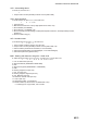
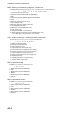
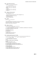
Table Of Contents

APPENDIX 2 DIGITAL INTERFACE
AP-8
RMB - Recommended minimum navigation information.
RMC - Recommended minimum specific GNSS data
ROT- Rate of turn
RTE - Routes
$**RMB,A,x.x,a,CCCC,CCCC,llll.ll,a,yyyyy.yy,a,x.x,x.x,x.x,A,a*hh <CR><LF>
1 2 3 4 5 6 7 8 9 10 11 121314
1. Data status (A=Data valid)
2. Cross track error (NM) (No use)
3. Direction to steer (No use)
4. Origin waypoint ID (No use)
5. Destination waypoint ID (Max. 15 characters)
6. Destination waypoint latitude (0000.0000 to 9000.0000)
7. N/S
8. Destination waypoint longitude (00000.0000 to 18000.0000)
9. E/W
10. Range to destination, nautical miles (No use)
11. Bearing to destination, degrees true (No use)
12. Destination closing velocity, knots (No use)
13. Arrival status (No use)
14.
Mode indicator (A= Autonomous, D= Differential mode, E=Estimated (dead reckoning
mode), M=Manual input mode, S= Simulator)
$**RMC,hhmmss.ss,A,llll.ll,a,yyyyy.yy,a,x.x,x.x,xxxxxx,x.x,a,a,a*hh<CR><LF>
1 2 3 4 5 6 7 8 9 10
111213
1. UTC of position fix (No use)
2. Status (A=data valid)
3. Latitude (0000.0000 to 9000.0000)
4. N/S
5. Longitude (00000.0000 to 18000.0000)
6. E/W
7. Speed over ground, knots (0.0 to 999.9)
8. Course over ground, degrees true (0.0 to 359.9)
9. Date (No use)
10. Magnetic variation, degrees E/W (No use)
11. E/W (No use)
12. Mode indicator (A= Autonomous mode, D= Differential mode, E=Estimated (DR), F=Float RTK,
M=Manual, P=Precise, R=Real time kinematic, S= Simulator)
13. Navigational status indication
(S=Safe, C=Caution, U=Unsafe, V=Navigational status not valid, null)
$**ROT,x.x,A*hh<CR><LF>
1 2
1. Rate of turn, deg/min, "-"=bow turns to port (No use)
2. Status (No use)
$**RTE,x.x,x.x,a,c--c,c--c,
● ●
,
c--c*hh <CR><LF>
1 2 3 4 5
● ●
n
1. Total number of sentences being transmitted (1 to 50, null)
2. Sentence number (1 to 50, null)
3. Sentence mode (c:complete route, all waypoints, w:working route, first listed
waypoint is "FROM", second is "TO" and remaining are rest of route)
4. Route identifier (Max. 15 characters, null)
5. Waypoint “n” identifier (Max. 15 characters, null)
● ●
Additional waypoint indentifiers