
Users Manual Part 8

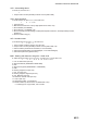
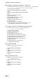
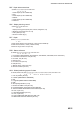
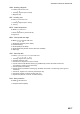
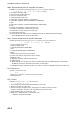
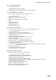
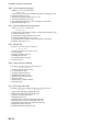
Table Of Contents

APPENDIX 2 DIGITAL INTERFACE
AP-9
THS - True heading and status
TLL - Target Latitude and Longitude
TTM - Tracked Target Message
VBW - Dual ground/water speed
$**THS,x.x,a*hh<CR><LF>
1 2
1. Heading, degrees True (0.0 to 359.9)
2. Mode indicator (A=Autonomous, E=Estimated (dead reckoning))
$**TLL,x.x,llll,ll,a,yyyy.yy,a,c--c,hhmmss.ss,a,a*hh<CR><LF>
1 2 3 4 5 6 7 8 9
1. Target number (No use)
2. Target latitude (0000.0000 to 9000.0000)
3. N/S
4. Target longitude (00000.0000 to 18000.0000)
5. E/W
6. Target name (No use)
7. UTC of data (No use)
8. Target status (No use)
9. Reference target (No use)
$**TTM,xx,x.x,x.x,a,x.x,x.x,a,x.x,x.x,a,c--c,a,a,hhmmss.ss,a*hh<CR><LF>
1 2 3 4 5 6 7 8 9 10 11
1213
14 15
1. Target number (00 to 99)
2. Target distance from own ship (0.000 to 99.999)
3. Bearing from own ship,degrees true/relative (0.0 to 359.9)
4. True or Relative (T, R)
5. Target speed (0.00 to 102.00, null)
6. Target course, degrees true/relative (0.0 to 359.9, null)
7. T=True or R=Relative
8. Distance of closest point of approach (0.00 to 99.99)
9. Time to CPA, min., "-" increasing (-99.99 to 99.99, null)
10. Speed/distance units (K=km, km/h, N=NM, kn, S= SM, mph)
11. Target name (other than null)
12. Target status (L=Lost, tracked target has been lost , Q=Query, target in the process of
acquisition, T=Tracking)
13. Reference target (No use)
14. UTC of data (numeric in six digits, null)
15. Type of acquisition (other than null)
$**VBW,x.x,x.x,a,x.x,x.x,a,x.x,a,x.x,a,*hh<CR><LF>
1 2 3 4 5 6 7 8 9 10
1. Longitudinal water speed, knots (-999.9 to 999.9)
2. Transverse water speed, knots (-999.9 to 999.9, null)
3. Status: water speed (A=data valid)
4. Longitudinal ground speed, knots (-999.9 to 999.9)
5. Transverse ground speed, knots (-999.9 to 999.9, null is invalid for IMO/R-Type radars)
6. Status: ground speed (A=data valid)
7. Stern transverse water speed, knots (No use)
8. Status: stern water speed (No use)
9. Stern transverse ground speed, knots (No use)
10. Status: stern ground speed (No use)