
Installation Instructions


17
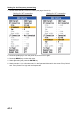
WAAS Setup: Choose how to use the WAAS signal when connecting with a WAAS receiver, for
example GP-320B. The message types (WAAS-00 to WAAS-27) are used as WAAS correction.
Choose WAAS-00 to enable WAAS.
Note: Currently, WAAS is only available in North America, and Japan and it is in the developmen-
tal stage in Europe and Japan. During the developmental phase the reliability and availability of
the WAAS signal cannot be guaranteed. Therefore, any position data should be verified against
other sources to confirm reliability. This function is available only when In/Out is selected at NMEA
Port.
TLL Output: Output the position specified by the MARK key to the plotter connected.
• Off: Does not output latitude/longitude.
• TLL: Outputs latitude/longitude.
• FURUNO-TLL: Outputs latitude/longitude, depth and water temperature. This requires
FURUNO-TLL enabled device.
Port Monitor: Port Monitor provides information for the data sentences input from the NMEA port.
Press the ENTER key to display the latest data sentence information. To display this information
on the Port 2 screen when two sensors are connected, set NMEA Port on the NMEA menu to In/In.
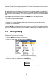
3.5 Heaving Setting
For the heaving feature to function correctly, set the distance between satellite compass antenna
(GPS sensor) and transducer as follows.
1. Press the MENU key to display the main menu.
2. Press T to select “Stabi” and then press the ENTER key.
3. Press T or S to select “Stabilization” and then press the ENTER key.
4. Press T to select “On” and then press the ENTER key.
5. Press T to select “Sensor” and then press the ENTER key.
6. Select the type of satellite compass connected and then press the ENTER key.
SC50/110
SC30