
Marine GPS System User Manual


8-2
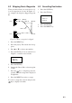
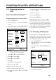
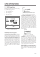
Own ship's position is marked as "00." A light-
blue line connects own ship with destination,
marked with a flag, and it shows the shortest
course to the destination. Range and bearing
from own ship to the destination appears at
the bottom of the screen.
WP801 0° 10nm
CSE 10.0° SPD 16.8kt 2D
DEP 110m TMP 16.0°C 14:30
POS 34°26.345’N 135°41.232’E
Destination
(flag)
Own ship’s
position
Course
Bearing and
range to
destination
00
Figure 8-4 Destination selected by cursor
Setting destination by event position/
MOB position
1. Press the GOTO key.
2. Press the GOTO key to select EVENT
List.
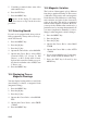
3. Press the ENT key. The event list appears.
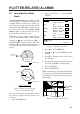
EVENT LIST
No.
MOB
001
LAT
32°59.892’N
32°59.954’N
LONG
129°59.893’E
130°00.236’E
: Cursor : Page change
ENT: Set CLR: Release
MENU: Sel Mode
Figure 8-5 Event list
4. Press ▼ or ▲ to select event position.
5. Press the ENT key.
Own ship's position is marked as "00." A light-
blue line connects own ship with destination,
marked with a flag, and it shows the shortest
course to the destination. Range and bearing
from own ship to the destination appears at
the bottom of the screen.
Setting a route as destination
1. Press the GOTO key.
2. Press the GOTO to select ROUTE List.
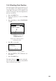
3. Press the ENT key. The route list appears.
ROUTE LIST
No.
01
02
PTS
6
4
TOTAL
302.11nm
201.27nm
TTG
41:36
35:52
: Cursor
CLR : Delete Route
*: In Use
ENT: Sel
ESC: Esc
Figure 8-6 Route list
4. Press ▼ or ▲ to select a route.
5. If you want to navigate the waypoints of
the route in the order reverse of which they
were entered, press the
key. Direction
selected appears at the top of the display.
6. Press the ENT key.
Own ship's position is marked as "00." Light-
blue lines run between route waypoints.
Range and bearing from own ship to the next
destination waypoint appears at the bottom of
the screen.