
Brochure


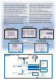


With the SC-110, a ship's heading is determined by
decoding the phase data in the GPS carrier frequency.
In principle, a pair of antennas A1(ref) and A2(fore),
each connected with an
associated GPS engine and
processor, are installed along
the ship's fore-aft line. The GPS
systems at A1 and A2 calculate
the range and azimuth to the
satellite.
The difference in range between
A1 and A2 is + n where is
19 cm and n* is automatically
found during the initialization
stage. A fraction of a carrier
wavelength, , is processed by
Furuno's advanced kinematic
technology in geographical
survey, thus determining a vector
(range and orientation) A1 to A2,
i.e., heading of ship relative to
north.
In reality, a third antenna is added to reduce the
influence of pitch, roll and yaw, and five satellites are
used to process 3D data (by 3rd sat), to reduce clock-
derived error (by 4th sat), and to
calculate n in the initial stage (by
5th sat).
If GPS signal is blocked by a tall
building or the vessel is under a
bridge, the 3-axis vibrating-gyro
rate sensors in the processor
unit take the place of the satellite
until all five satellites are in view.
The rate sensors also contribute
to regulating the heading data
against pitch, roll and yaw
together with the third antenna
(A3 in the illustration).
*Ambiguity "n" is resolved by
LAMBDA algorithm developed by
Prof. Teussen, Delft University of
Technology, The Netherlands.
Heading
Antenna A1
Antenna A2
Antenna A3
Difference between the
range from satellite to
antenna 1 and the range
to antenna 2.
n
Fore-aft line
Vector to decide heading
North
Principle
Furuno's high-grade satellite compass
provides superior heading accuracy for
AIS, ECDIS, Radar and more
Compass Rose
Mode
■ Provides highly accurate heading data
for autopilot, radar, AIS, Sonar and
plotting systems
■ IMO MSC.116(73) type approved as a
verified THD (Transmitting Heading
Device) with high accurate 0.3° RMS
■ Rapid 45°/s follow-up rate greatly
exceeds IMO High Speed Craft
requirements 20°/s
■ High accurate GPS, WAAS Data –
SOG, COG, ROT, and L/L
■ High Contrast 4.5" Silver Bright LCD
■ Precision Pitch/Roll Data in Analog
and Digital formats for vessel
stabilizers, sonar, etc.
■ Multiple High Speed Heading Data
Output in IEC 61162-1/2
(NMEA0183/HS)
■ 100% free of yearly or regular
maintenance – No Recurring Costs
■ Unique Tri-Antenna System improves
system accuracy and reduces the
effects of yaw, pitch and roll