
User's Manual


MaxSea TimeZero Recreational v2
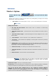
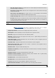
Vector chart
o Chart Color Palette : You can customize the appearance of charts by turning on and off
layers of information. You can modify the display level in pop-up menu which gives you the
choice between various display configurations: Standard (pre-configured level) / S52 /
Sunlight
o Chart Symbol : choose the symbolic object vector chart configuration between
International (IALAA system) or S52 (IALAB system)
o Select values in each corresponding list to configure the Shallow Contour, the Safety
Contour and the Deep Contour
o Check each box to display on chart following information : Names of Buoy / Light
Description / Light sectors / Text (important) / Text (other)/ etc....
o Display Soundings in red when Depth value is inferior to the limit value that you have
selected in following pop up menu.
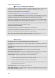
S-52 Custom :
"S-52 Vector Chart Display Mode" : You can modify the display level in pop-up menu which gives
you the choice between various display configurations: Custom (pre-configured level) / Base /
Standard / Other / fishing.
When the Custom chart display mode is chosen, a list of check boxes allows you to choose which
information you will display on chart.
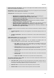
Routing: Setting Up
1. Save all Routings in Planning Space: Check to save automatically all Routings in the Planning
list and to display them later again
2. Routing Transparency: Adapt Routing display transparency overlaying on the chart (25% is
chosen by default)
3. Isochron Interval: Select an interval isochron value under the drop down menu (automatic is
selected by default)
4. Polar Curves Percentage: enter a value from -50 to +50 or move the cursor along the slide bar
to modify
5. Check Waves and /or Tidal Streams and/or Oceanic Currents boxes to take in account these
values in the routing calculation.
6. Enter acceptable limits of the Wind speed and for height of Waves
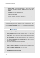
If MaxSea is an Explorer or professional Version configured with the Racing Module you will be
able to adjust and modify the Wind Forecast:
1. Increase or decrease the wind speed (%): move the cursor along the slide bar to modify to
increase or decrease the percentage.
2. Increase or decrease the wind speed (value): enter directly a value
3. Change Weather File Time: enter a specific time HH:MM.
4. Change Weather File in Latitude and Longitude
5. Change Weather File in Direction
152