
User's Manual


Routes & Waypoints
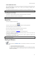
Right Click on a Divider line to erase the selected or all divider lines
To move a divider anchor point, simply select it then drag it to another location.
Importing & Exporting Marks and Routes
The "Import/Export" option available under the MaxSea Button will allow you to Import or Export
navigation objects to a file.
MaxSea TimeZero can Export or Import information in various formats:
GPX (GPS eXchange Format) is an XML format designed for describing GPS data between
software applications. This is the native format used by MaxSea TimeZero
KML or Keyhole Markup Language is an XML-based language format for expressing
geographic annotation and visualization on existing or future Web application such as
Google Earth
CSV or Comma separated values is a text format structured in a table of lists form. The
CSV format used by MaxSea TimeZero was designed to be directly compatible with
NavNet3D.
ONF - Nobeltec personal data files from Nobeltec VNS and Admiral software previous
version (marks, circles, lines, areas, routes and tracks).
P-Sea WindPlot files from which Marks and tracks can be imported
Import 3D data:
XYZ - PBG MaxSea v12 export text files containing geo localized depth data from Maxsea
previous version v9 and v12. (unencrypted format basic and extended format only)
PTZ - MaxSea v12 PBG database the 3D Vector Charts points contained in the PTZ file will not
be imported. The same data can be found in the mm3d Chart data (dbt file)
Olex Depth Database Export these files contain the user 3D data generated from olex
software.
BTH - Nobeltec , files which contain the user generated 3D bathy data from Nobeltec Software.
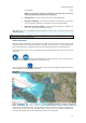
Importer des images:
JPEG: Personal photos can be imported and geo localized on the chart in MaxSea, if you have a
digital camera that has an embedded GPS and can geo tag the photos (as the Iphone for
example), if you have a digital camera correctly setup with Date/Time and a matching Track or
Logbook information in MaxSea, the other photo without of information will be ignored.
Note: Only the GPX format will transfer Data with complete integrity. When other formats are used, some
information might be lost during the transfer.
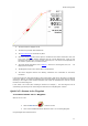
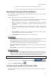
To Import or Export data, click on the MaxSea menu button ,
then select the
Import/Export option
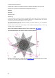
Activate Search and Rescue Function (SAR)
The Search And Rescue (SAR) is the search for and provision of aid to people who are in distress or
imminent danger.
31