
User's Manual


Weather Routing
What is Weather Routing ?
- The Weather Routing is an optional module. To check if you have this add-on, select "About
MaxSea" under the MaxSea Menu. The Routing Module would appear listed under "Activated Module".
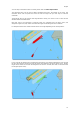
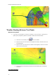
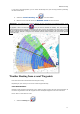
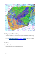
The unique Routing algorithm developed by MaxSea uses the isochrons method (displayed on the
charts using yellow and purple curves). Each isochron represents a group of points that can be reached
in the same amount of time. The calculation of the isochrones take into account the weather forecast
(wind, Waves), currents and the boat characteristics. The boat characteristics are factored into the
equation from a polar curve diagram (called "Wind Polar") which relate boat speed to wind speed at a
given wind-angle. One of the most important factor involved in achieving the optimum course is the
weather forecast: make sure to use the most up to date weather forecast available when launching a
routing. Another important factor are the polars file loaded in MaxSea. While the default Wave Polar
can be use with great result in most of the case, the Wind Polar should be adapted to each sailing
boat. At minimum, it is recommended to use a Wind Polar file from a boat of the same category. You
can download various Wind Polar files from the maxsea website (Log In to "My MaxSea" and select
"Download").
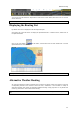
Before Launching a Routing
1. Select the Planning WorkSpace.
2. Download or Open a Weather File in MaxSea. Make sure the weather file covers the same
geographic location as your departure and arrival points. .
1.
3. Select a Departure Date from the Virtual Time box on the lower right (if you want to start the
routing now, click on the "Actual Time" button).
4. Launch the Routing Calculation using the "Launch Routing" tool from the ToolBar (refer to
next chapters)
75