
User Guide
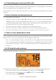
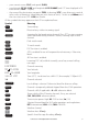

• your current course (128°) and speed (5.0Kt)
• your latitude (55°33.122N) and longitude (012°42.408E) and UTC time displayed in 24
hour format (14:43 - 2:43pm)
• the name of the destination waypoint (FISH), its bearing (275°), your distance in nautical
miles, mile, or kilometres (depending on your choice of units) - in this case, 800nm, and
the cross track error (XTE - 0.00) are shown.
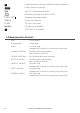
All the symbols that may appear on the LCD are explained here:
Symbol Meaning
TX
Transmitting.
Receiver busy with an incoming signal.
SCAN
Scanning for the broadcasting channel. Press PTT to stop scanning.
When the broadcasting channel is found, scanning stops at that
channel.
DW
Dual watch mode.
TRI
Tri watch mode.
DSC
DSC function is enabled.
ATIS
ATIS is enabled for use in European inland waterways. Otherwise,
blank.
AIS
AIS function is enabled.
Incoming DSC call, or blinks to notify you of any unread call log
messages.
DISTRESS Channel name tag.
55 33.122N Your latitude.
012
4
2.408E Your longitude.
14:43 UTC Time (UTC). Local time has suffix LOC (for example; 12:30pm LOC).
16 Channel selected.
LOCAL
Local calling is selected. Otherwise, blank for distance calling.
SKIP
Channel is temporarily deleted ‘skipped’ from the SCAN operation.
A
Channel suffix, if applicable - A or B - otherwise blank.
CH1
Shows which of the 3 favorite channels, if any, are selected.
CH1, CH2, CH3 - otherwise blank.
Hi
Transmission power. High (Hi) 25 W or Low (Lo) 1 W.
INT
Selected channel bank for VHF radio operations and regulations.
INT=International; USA=USA; CAN=CANADA.
Wx
Weather channel.
Weather alert. US only.
SAME
Specific Area Message Encoding. US only.
BUSY
Lowrance - Link-8 Operation Instructions 9