
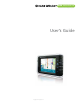
User`s guide


Rand McNally GPS Navigator User’s Guide | INTRODUCTION 1Help (866) 627-3526
1 INTRODUCTION
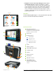
Congratulations on purchasing the Rand McNally GPS Navigator
personal navigation system!
About GPS
The Rand McNally GPS Navigator uses GPS (Global Positioning System)
satellites, direction-sensing electronics, and a map database to
calculate and display route directions.
The GPS is based on 24 satellites, which orbit the earth and continu-
ously emit signals. The GPS receiver located in the navigation device
receives those signals and calculates, based on the runtime of the
signals, its distance from the respective satellites. The Rand McNally
GPS Navigator uses this information to calculate your current geo-
graphic position.
The signals of at least three satellites are needed to determine the
longitude and the latitude. The determination point has an accuracy
of about 9 feet.
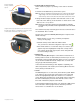
Your GPS Navigator is a portable device that interprets your GPS
location and then plots it onto a map using longitude and latitude.
It can then use the stored map to calculate a route between two points.
Navigation Devices — what you should know
In general, using most types of navigation devices you will encounter
the following:
The GPS satellites can only determine your current location
— they do not send maps, updates or calculate routes.
The device is responsible for those functions.
For first time use or if the device has been off for a long
period of time, there may be a delay in receiving the initial
satellite signal depending on your position and the position
of the satellites. This could take up to 10 minutes or longer.
With normal usage, the typical wait time to calculate a
position will be less than 2 minutes.
The initial GPS signal lock is best established when your
device is standing still. If the device is in motion (as in a
moving vehicle) the signal can take longer to initially
connect. Once the device makes the initial connection,
it will be able to follow you as you move and navigate.
Satellite navigation receivers will not work underground,
inside a building, or if there are obstructions to the navigation
device. Areas where there are tall buildings or dense stands
of trees, or while driving in a tunnel may cause the signal
to disconnect temporarily. The device will reconnect when
free of obstructions.
When you turn off the navigation device or when the
reception of GPS signals is obstructed, navigation is inter-
rupted but doesn’t shut down. As soon as the receiver
reconnects the navigation system notices a possible change
of your current position and recalculates the route. You
may simply continue navigation.
ÿ
ÿ
ÿ
ÿ
ÿ