
User`s guide
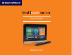


Rand McNally IntelliRoute
®
TND
TM
510 User’s Guide Version 2.0.1 2
About GPS
The Global Positioning System (GPS) is a constellation of satellites that a GPS
receiver uses to calculate geographical positions. To determine a position, data
from at least three satellites is required. To determine altitude, the data from four
or more satellites is required. Accuracy of the positioning varies from 10 feet to
several hundred feet, depending on vehicle placement and the surrounding
environment.
Geographical terrain (such as mountains), man-made structures (such as
highway overpasses, bridges, and tall buildings), as well as weather can interfere
with the GPS signal. For best GPS reception, position the IntelliRoute® TND™ 510
and mount with a clear line of sight to the sky.
Some vehicles may have a limited view of the sky due to metal sun shields or
a metallized windshield coating. If your unit does not appear to receive signals
well inside your vehicle but works well outside, contact Rand McNally for an
available external antennae.
Map data used by the IntelliRoute® TND™ 510 includes the geographical
coordinates for address locations and points of interest (POIs). With GPS
reception, your device calculates a route to your selected location.