TomTom Rider User Manual 17.
Contents Welcome to navigation with TomTom 7 What's new 8 What's new compared to Rider 450 ............................................................................. 8 TomTom videos .................................................................................................... 8 Installing your Rider 10 Mounting on a motorcycle ...................................................................................... 10 Using the anti-theft solution ...............................................
Planning a thrilling round trip route using stops ....................................................... 36 Planning a thrilling ride to a destination ................................................................ 38 Looking at trip statistics ........................................................................................ 39 What's on the screen 41 The map view..................................................................................................... 41 The guidance view ...........
Quick search 69 Choosing which search to use ................................................................................. 69 Using quick search ............................................................................................... 70 About search .................................................................................................. 70 Entering search terms ....................................................................................... 70 Working with search results.......
Reordering stops on a route .................................................................................. 131 My Routes 132 About My Routes ................................................................................................ 132 About GPX and ITN files ....................................................................................... 132 Adding to My Routes using MyDrive .......................................................................... 133 Saving a route ...................
Settings 161 Appearance ...................................................................................................... 161 Display ........................................................................................................ 161 Route Bar ..................................................................................................... 162 Guidance view ............................................................................................... 163 Automatic Zoom..................
Welcome to navigation with TomTom Welcome to your TomTom Rider, your essential motorcycling companion! We know you probably have more exciting things to do than read manuals so here are some quick links to some important bits: What's new compared to Rider 450 Installing your Rider Connecting a headset TomTom services Connecting a smartphone Wi-Fi® connection Road Trips collection - sending a route to your Rider We hope you enjoy discovering your next adventure using your new Rider! Note: You
What's new What's new compared to Rider 450 Rider 550 only TomTom Road Trips Get on the road with the world's best curated routes available exclusively to sync with your Rider 550. Learn more: Road Trips collection - sending a route to your Rider Third party Points of Interest (POIs) Enjoy over 1000 pre-installed points of interest for motorcyclists. Rider 500/550 Updates via Wi-Fi® Get the latest maps and software for your TomTom Rider using built-in Wi-Fi. No computer needed.
The TomTom Rider Get inspiration for your Rider: www.youtube.com/watch?v=kbHfzuflTF0 https://www.youtube.com/playlist?list=PLSoQAVympWk4HbxQ-kv83xqcC-KDSbEl5 See how to mount your Rider without the anti-theft solution: www.youtube.com/watch?v=w0UHEIlJ060 See how to mount your Rider with the anti-theft solution: www.youtube.com/watch?v=5SE8zUasp2I See how to get TomTom Traffic via your iPhone: www.youtube.com/watch?v=HIwYh5nYAok See how to get TomTom Traffic via your Android™ Smartphone: www.youtube.
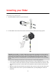
Installing your Rider Mounting on a motorcycle 1. Attach the RAM™ mount kit to your motorcycle. 2. Fix the holder to the mount and connect the wires to your motorcycle's wiring system. Important: The red POS (+) contact needs to be connected to the motorcycle's wiring loom at a point between the ignition and the +12V battery supply. The black NEG (-) wire needs to be connected to the motorcycle's wiring loom at a point between the ignition and the -(GND) battery supply.
Do not overtighten nuts and screws. You may crack parts of the mount kit or damage your handlebars if you overtighten nuts or screws. If you are using the u-bolt, don’t forget to put the rubber caps provided over the exposed threads. Important: Damage due to modifications, improper installation, road hazards or accident, are not covered. Neither RAM nor TomTom shall be liable for any injury, loss, or damage, direct or con-sequential, arising out of improper installation, or inability to use product.
A RAM lock for the mount. This lock prevents the unscrewing of the RAM arm from the motorcycle. A RAM Pin-Lock™ for the TomTom Rider itself. This lock prevents the disconnection of the TomTom Rider from the dock. Important: Both locks have keys so you need to make sure that you keep these two extra keys with you at all times! To use the anti-theft solution, do the following: 1. Lock the RAM mount to your motorcycle as shown below.
3. Attach the RAM Pin-Lock. 4. Attach the RAM arm to the RAM mount and the active dock.
5. Attach the RAM Pin-Lock cap on to the RAM Pin-Lock. 6. Tighten the RAM Pin-Lock as shown. 7. Remove the RAM Pin-Lock cap.
8. Lock your TomTom Rider with the key to prevent removal from the mount Installing in your car If your box contains a car mount, use the supplied mount to install your TomTom Rider in your vehicle. Read the instructions about positioning your device before you install your Rider. If your box contains a car mount, install your Rider by doing the following: 1. Connect the supplied USB cable to the mount. Note: Use ONLY the USB cable supplied with your Rider. Other USB cables may not work. 2.
6. Turn the grip near the base of the mount in a clockwise direction until you feel it lock. 7. Place your Rider in the mount, making sure that it clicks into place. Tip: With the High-Speed Dual Charger you can charge your TomTom Rider and smartphone at the same time. Switching on and off Switching your device on Press the On/Off button until your device starts. If the device was off you see the map view. If your device was sleeping you see the last screen you were looking at.
Setting up Note: The language you choose will be used for all text on the screen. You can always change the language later in Language and Units in the Settings menu. When you first switch on your TomTom Rider, you have to answer a few questions to set it up. Answer the questions by touching the screen. GPS reception When you first start your TomTom Rider, it may need a few minutes to determine your position. In future, your position will be found much faster.
First, check that the battery is charged. To charge the battery, connect your Rider device to the car charger. It can take 3 - 5 hours to fully charge the battery depending on the type of device. Important: Do not charge your device using your vehicle's own USB port because it is not powerful enough. If this does not solve the problem, you can perform a reset. To do this, press and hold the On/Off button until your Rider begins to restart.
Connecting a headset We recommend using a headset with your TomTom Rider to hear spoken instructions, and to hear warning sounds on your Rider. You can also use your headset for making and receiving calls in conjunction with your phone. This makes riding with your Rider as safe as possible. Note: To hear voice instructions as well as phone calls, your headset must support multiple channels. For more information and a full list of compatible headsets, go to Headset Compatibility.
TomTom services About TomTom services TomTom services give you real-time information about traffic and speed cameras on your route, and lets you sync using TomTom MyDrive. Smartphone Connected devices use your existing smartphone data plan to access TomTom Traffic as well as other services like TomTom Speed Cameras and TomTom MyDrive by connecting to your smartphone using Bluetooth®. Check tomtom.com/connect for more information.
Connecting a smartphone Why do I want to connect a smartphone to my device? Connect your smartphone to your TomTom Rider to use these features: TomTom services Receive real-time traffic information, speed camera updates and MyDrive using your phone’s data connection. This feature uses approximately 7 MB of data per month. Phone calls See who is calling on your Rider so you can decide if you want to answer an incoming call.
When your phone is connected, you see this icon on the map or guidance view: You can easily change the phone features you want to use in Bluetooth in the Settings menu. Disconnecting a smartphone You can disconnect your phone in the following ways: Switch off Bluetooth on your phone. Switch off or reset your Rider. Select Bluetooth in the Settings menu. Select your phone. Select Unpair to disconnect your device from your phone.
Depending on your phone's Operating System, this network, or PAN, might be called one of the following names: Personal Hotspot Tethering or Bluetooth Tethering Tether or Bluetooth Tether The PAN function is probably already in your phone's Operating System, or you can download an app to create a PAN. Note: Some mobile service providers don't allow their users to use a PAN. If your phone doesn't have the PAN function, you should contact your service provider for more information.
Wi-Fi connection About Wi-Fi® The easiest way to manage your maps, software and all your device content is over a Wi-Fi connection. Your device can be updated using Wi-Fi without the need to connect to a computer. It remembers previously connected Wi-Fi networks so you can keep your device up to date when you are in range of that network. Before you begin, make sure that you have access to an unrestricted Wi-Fi network, such as a personal home network.
1. Select Settings in the Main Menu, then select Wi-Fi. You see a list of available Wi-Fi networks and saved Wi-Fi networks that are currently out of range. Tip: Scroll down to go to the list of out-of-range saved networks. 2. Select the Wi-Fi network that you want to forget. 3. Select Modify then select Forget. Your device is disconnected from the Wi-Fi network. Note: The Wi-Fi network still appears in the list, but your device will not automatically connect to it.
Recently blocked and unblocked roads Traffic directions Turn restrictions For more information, see Map Share. Speed Camera updates When a Speed Camera update is offered, you can choose which countries on your map you want to update. Voices You may also be offered new voices as an update. Installing updates and new items Note: If Wi-Fi is not available or is not stable, you see instructions on how to get updates using a USB connection to your computer.
Using your Rider Navigation buttons On the map view or guidance view, select the Main Menu button to open the Main Menu. The following navigation buttons are available in the Main Menu: Note: Not all features are supported on all devices. Search Plan a Thrill Select this button to search for an address, a place or a Point of Interest, then plan a route to that location. Select this button to plan a thrilling ride for a roundtrip or to a destination.
Add Work Select this button to ride to your work location. If this button is not included in your main menu, go to My Places to set up your work location. Ride to Work Current Route / Current Track Select this button to clear or change your planned route or track. Start Recording Select this button to start or stop recording a track. My Places Parking Petrol Station Select this button to show your saved places. Select this button to find car parks. Select this button to find petrol stations.
Trip Statistics Settings Select this button to see trip statistics about how far you've been riding, how long you've been riding, and also at what speed. Select this button to change Settings. The glove-friendly keyboard Switching to the glove-friendly keyboard The glove-friendly keyboard has large buttons so that you can make selections more easily while wearing motorcycle gloves. See Entering search terms for instructions on how to select different keyboard layouts.
Available keys The keys shown below are available when using your TomTom Traffic in either portrait or landscape orientation. Using quick settings Quick settings make it easier for you to use a range of settings when wearing gloves. To use quick settings, select the quick settings button in the main menu, the map view or the guidance view.
You see a screen with large buttons and a volume control: This button shows that you will hear voice instructions. Select the button to switch off voice instructions. You will no longer hear spoken route instructions but you will still hear information such as traffic information and warning sounds. Tip: You can select the types of instructions you want to hear. Select Voices in the Settings Menu and select the instructions you want to hear. This button shows that you will not hear voice instructions.
When wearing gloves, select the plus (+) and minus (-) buttons underneath the volume slider to change the volume, instead of trying to move the slider with gloves on. Important: When using a headset, the volume control may not be available because your headset doesn't support remote volume control. If this is the case, use the volume control button on the headset itself to change the volume.
The route is shown on the map together with stops (flags) and start and end points. Using the buttons at the bottom of the box, you can edit the route, save the route as a .GPX file or Save to My Routes. Tip: Click the grey arrow near the road trip name to go back to the previous screen. 4. Click Save to My Routes. 5. To send the route to your device, click on the My Routes icon and click on the name of the road trip. 6. Make sure that Sync this route as a track with my devices is enabled.
The road trip is synced to your Rider as soon as you are either connected to your computer, within range of your wireless network or connected to your phone. You must be logged in to MyDrive. Road Trips collection - planning a route to a stop The TomTom Road Trips collection allows you to discover the world’s most amazing riding routes, from legendary coastal rides like the Amalfi Coast to classic rides like Route 66.
4. Click on a flag to see what is of interest at that point on the road trip. For example, you can see the Bay of Islands flag is selected below and, if available, you are shown information and reviews about that stop. 5. Click Start Here to start your route from this point, or Add to My Places or Send to Device. 6. Click Plan route to plan a route to that stop. You can then choose from settings including your vehicle type, fast or thrilling route etc.
You may then get offered a choice of routes as shown below. 8. Click on your chosen route option and then use the buttons at the bottom of the box to share your route, save it or Send to Device. Planning a thrilling route You can use the Plan a Thrill button to create interesting rides on the spot. This is especially useful for a day when you have some spare time and just need a simple way to create a thrilling ride.
2. Select Plan a Thrill. The map view opens. 3. Move the map and zoom in until you can see the place you want to ride through. 4. Create a stop by quickly tapping the map. Your Rider plans a thrilling round trip through your chosen stop. Tip: The direction of the round trip is random. If you have at least 2 stops on your route, you can change the direction of travel by reordering the stops. Arrows on the planned route show the direction of travel. 5.
7. When you have planned your thrilling route, select Ride. Your route is shown on the map view, then guidance along your route begins. As soon as you start riding, the guidance view is shown automatically. Planning a thrilling ride to a destination You can plan a route to a destination using the map. The route to your destination will be along the most interesting roads from your current location. Tip: You can also plan a route to a destination then choose Winding route as the route type. 1.
Your Rider plans a thrilling route to your chosen destination. 5. If you want to add more stops to your route, move the map and select more stops. Your Rider plans a thrilling route through your chosen stops to your destination. Tip: Select the pop-up menu button to reorder your stops. 6. Select the level of turns and the degree of hilliness for your thrilling route. Select this button to choose one of three settings for turns. Select this button to chose one of three settings for hilliness.
Statistics for your current trip To see statistics for the trip you are riding now, select the Since --/--/-- tab. To start a new trip, select the Clear trip button, just like resetting an odometer in a car. After stopping your bike, if you don't press the Clear trip button, the statistics just carry on incrementing when you start moving again. This means you get accurate statistics for trips that span several days or several rides within a day.
What's on the screen The map view The map view is shown when you have no planned route. Your actual location is shown as soon as your Rider has found your GPS location. You can use map view in the same way as you might look at a traditional paper map. You can move around the map using gestures, and zoom using the zoom buttons.
1. Back button. This button returns the map to an overview of your whole route or, if no route is planned, moves the map to put your current location at the centre. 2. Switch view button. Select the switch view button to change between the map view and the guidance view. When in map view, if you are driving, the small arrow rotates to indicate your direction of travel relative to north, with north being up. 3. Zoom buttons. Select the zoom buttons to zoom in and out. 4. Current location.
11. Phone button. 12. Route bar. The route bar is shown when you have planned a route. The guidance view The guidance view is used to guide you along the route to your destination. The guidance view is shown when you start driving. You see your current location and details along your route, including 3D buildings in some cities. Note: 3D buildings in guidance view are not available on all devices. The guidance view is normally in 3D.
The distance to your next turn. The name of the next road on your route. Lane guidance at some junctions. Note: Select the instruction panel to see a list of turn-by-turn text instructions for your planned route. 4. Route symbols. Symbols are used on your route to show your starting location, your stops, and your destination. 5. Main Menu button. Select the button to show the Main Menu. 6. Speed panel. This panel shows the following information: The speed limit at your location.
The arrival information panel shows the following information: Tip: If your destination is in a different time zone, you see a plus (+) or a minus (-) sign and the time difference in hours and half hours in the arrival information panel. The estimated time of arrival is the local time at your destination. The estimated time that you will arrive at your destination. The length of time to drive to the destination from your current location.
For remaining distances longer than 50 km (31 miles), only the next 50 km (31 miles) is shown. The destination icon is not shown. Tip: You can scroll the route bar to see your whole route (not available on iOS). For remaining distances between 10 km (6 miles) and 50 km (31 miles), the complete distance is shown. The destination icon is shown fixed at the top of the route bar. For remaining distances of less than 10 km (6 miles) the complete distance is shown.
This symbol shows the status of the Bluetooth connection to your phone. This symbol shows the power level of the battery in your Rider. This symbol shows that your Rider is connected to Traffic. This symbol shows that your Rider is not connected to Traffic. This symbol shows that your Rider is connected to MyDrive. This symbol shows that your Rider is not connected to MyDrive. This symbol shows that your device is connected to the internet using Wi Fi.
Press and hold Put one finger on the screen for more than 0.5 second. Example of when to use this: Opening the pop-up menu for a place on the map. Pinch to zoom Touch the screen with your thumb and a finger. Move them apart to zoom in or move them together to zoom out. Example of when to use this: Zooming in and out on the map. Tip: Pinch to zoom isn't available on all devices. If pinch to zoom isn't available, use the zoom buttons to zoom in and out. Tap or select Tap a single finger on the screen.
Calls and smartphone notifications About phone calls To make phone calls, you must first connect your headset and connect your phone to your Rider. You can make calls and receive incoming calls using your TomTom Rider in conjunction with your headset or phone. You can use your voice or a combination of voice and touch to make and receive calls. Your Rider can also receive SMS messages, which are also known as text messages, and instant messages from other apps.
Your smartphone assistant says your phone is dialling. 3. Jack answers and you have your conversation. 4. To hang up, use the controls on your headset or phone. Receiving an SMS or IM 1. When someone sends you an SMS or IM, you see their name if they are in your contacts list, and the name of the app that was used to send it, for example WhatsApp. Voice control announces the message and who it is from. 2. Select Read Aloud to have the message read to you by your device. 3.
2. Select Settings in the Main Menu, then select Bluetooth. If you have a phone connected you see the Bluetooth Setting screen. 3. Select your phone name. 4. Slide the toggle for Smartphone messages to turn messages on or off. Talking to Siri or Google Now™ About Siri Siri is the Apple personal assistant available on the IPhone. About Google NowTM Google Now has the ability to be a voice-activated personal assistant. Talking to Siri or Google Now using your Rider 1. Select the Phone button.
Traffic About TomTom Traffic TomTom Traffic is a TomTom service providing real-time traffic information. In combination with historical road usage data, TomTom Traffic helps you plan the optimum route to your destination taking into account the current local traffic conditions and the weather. Your TomTom Rider regularly receives information about the changing traffic conditions.
The stops on your route. Tip: To quickly remove a stop, select it in the route bar and use the pop-up menu. Petrol stations that are directly on your route. TomTom Traffic incidents. TomTom Speed Cameras and Danger Zones. Rest stops directly on your route. You can choose the information you see on your route. The symbols are in the order that they occur on your route. For traffic incidents, the symbol for each incident alternates between showing the type of incident and the delay in minutes.
Tip: Select an incident on the map to see more detailed information. 1. Traffic incident that affects your route in your direction of travel. A symbol or number at the start of the incident shows the type of incident or the delay in minutes, for example 5 minutes. The colour of the incident indicates the speed of traffic relative to the maximum allowed speed at that location, with red being the slowest. The stripes on the traffic jam are also animated to show the speed of the traffic, where appropriate.
To get more information about an incident, select an incident in the route bar. The map opens zoomed in on the incident and an information panel opens showing detailed information about the traffic incident. The information shown includes: The The The The cause of the traffic incident - for example accident, road works, lane closure, or weather. severity of the incident - slow traffic, queuing traffic or stationary traffic. delay time. length of the incident.
The colour of the incident indicates the speed of traffic relative to the maximum allowed speed at that location, with red being the slowest. The stripes on the traffic jam are also animated to show the speed of the traffic, where appropriate. Traffic speed is 0% to 20% of the allowed speed. Traffic speed is 20% to 40% of the allowed speed. Traffic speed is 40% to 100% of the allowed speed. Traffic speed is normal. Road closed, no traffic.
3. Select Avoid in the pop-up menu. A new route is found that avoids the traffic jam. Avoiding a traffic jam using the map 1. On the map view, zoom in and select the traffic jam that is on your route. The traffic jam with an information panel is shown on the map. 2. Select the pop-up menu button. 3. Select Avoid. A new route is found that avoids the traffic jam. Advanced Lane Guidance Note: Lane guidance is not available for all junctions or in all countries.
Syncing using TomTom MyDrive About TomTom MyDrive TomTom MyDrive is the easy way to set a destination, share locations and favourites, and save your personal navigation information. MyDrive synchronises your TomTom Rider using your TomTom account. You can use MyDrive in a web browser on a computer or as a mobile app on a smartphone or tablet. Important: To use TomTom MyDrive you need a compatible navigation device.
Road Trips collection - sending a route to your Rider The TomTom Road Trips collection allows you to discover the world’s most amazing riding routes, from legendary coastal rides like the Amalfi Coast to classic rides like Route 66. Sending a route from the Road Trips collection to your TomTom Rider To use the Road Trips collection, do the following: 1. Log in to MyDrive at mydrive.tomtom.com. 2.
The route is shown on the map together with stops (flags) and start and end points. Using the buttons at the bottom of the box, you can edit the route, save the route as a .GPX file or Save to My Routes. Tip: Click the grey arrow near the road trip name to go back to the previous screen. 4. Click Save to My Routes. 5. To send the route to your device, click on the My Routes icon and click on the name of the road trip. 6. Make sure that Sync this route as a track with my devices is enabled.
The road trip is synced to your Rider as soon as you are either connected to your computer, within range of your wireless network or connected to your phone. You must be logged in to MyDrive. Road Trips collection - planning a route to a stop The TomTom Road Trips collection allows you to discover the world’s most amazing riding routes, from legendary coastal rides like the Amalfi Coast to classic rides like Route 66.
4. Click on a flag to see what is of interest at that point on the road trip. For example, you can see the Bay of Islands flag is selected below and, if available, you are shown information and reviews about that stop. 5. Click Start Here to start your route from this point, or Add to My Places or Send to Device. 6. Click Plan route to plan a route to that stop. You can then choose from settings including your vehicle type, fast or thrilling route etc.
You may then get offered a choice of routes as shown below. 8. Click on your chosen route option and then use the buttons at the bottom of the box to share your route, save it or Send to Device. Setting a destination using MyDrive When you are logged in to MyDrive using a web browser or the MyDrive app, you can select your destination on the map and send it to your navigation device.
Creating a route with stops 1. In a web browser, log in to your TomTom account. 2. On the map, select a destination. Tip: You can search for a destination or you can move the map and select a destination on the map. You can also select a destination from Recent Destinations in the Main Menu or your My Places list. 3. On the map, select a stop in the same way as you selected your destination, then select Add Stop. The stop is added to your route.
Tip: Alternatively, select My Places, followed by Recent Destinations. 2. Select Edit List. 3. Select the locations you want to delete. 4. Select Delete. Set a phone contact as your destination using the MyDrive app When you are logged in to the MyDrive app, you can select a contact in your phone's contacts list to set as your destination. Your contact must have a full address which is in the correct order. The destination is shown on the map and you can send it to your navigation device.
Importing a community POI list You can find collections of community POIs on the Internet and upload them to My Places using MyDrive in a web browser. A POI collection might contain, for example, campsites or restaurants for the area you are travelling in, and provides an easy way to select a location without the need to search for the location each time. Tip: Some TomTom Navigation devices have POI lists pre-installed. Your Rider uses .OV2 files for POI collections.
Using GPX files You use MyDrive on your computer to import .GPX track files to your TomTom device. The tracks are saved in the My Routes menu. Your device will navigate along the GPX track exactly and will not offer to replan your route, even if a faster route is available. Importing a track GPX file Note: Your Rider needs at least 400 MB free space before it can import .OV2 and .GPX files. If you see the message You need more space, make space available by deleting unwanted .OV2 or .
Make sure that there is at least 400 MB of free space on your device before syncing your device with MyDrive. If there is not enough space, your MyDrive information will not be synced. You can check the amount of available space by going to About in the Help menu on your device. Note: Syncing a lot of information to your device may take some time.
Quick search Choosing which search to use The following two types of search are available: Quick search Start typing your destination, place or POI to immediately see a list of street names, places and POIs that match. Step by step search Find your destination in easy steps. For an address, enter the city, then the street, then the house number. For a POI, enter where you want to search, then the type of POI you want to search for.
Using quick search About search QUICK SEARCH ONLY You can use the search feature to find a wide range of places and then navigate to them. You can search for the following: A A A A A specific address, for example, type in 123 Oxford Street, London. partial address, for example, type in Oxford st Lon. type of place, for example, type in petrol station or restaurant. place by name, for example, type in Starbucks. postcode, for example, type in W1D 1LL for Oxford Street, London.
Enter your search term here. As you type, matching addresses and POIs are shown. Tip: If you press and hold a letter key on the keyboard, you get access to extra characters if they are available. For example, press and hold the letter "e" to access characters 3 e è é ê ë and more. Tip: To edit, select a word you have already typed to place the cursor. You can then insert or delete characters. 3. Type of search button.
Tip: Select the Shift key once to make the next letter you type upper case. Double tap the Shift key to use Caps-Lock where all the letters you type are upper case. Select the Shift key once to quit Caps-Lock. Tip: To cancel a search, select the map/guidance view button in the top right-hand corner of the screen. Working with search results QUICK SEARCH ONLY Your search results are shown in two columns.
If you show the result on the map, you can use the pop-up menu to add the location to My Places. If a route is already planned, you can add the location to your current route. Note: The best search results are shown on the map. When you zoom in, the lower ranked search results are gradually shown. About postcodes When searching using a postcode, your results depend on the type of postcode used in the country that you are searching in.
About mapcodes QUICK SEARCH ONLY In countries where roads and houses have no names or addresses, you can use a mapcode instead. A mapcode represents a location. Every location on Earth, including those in the sea like islands and oil rigs, can be represented by a mapcode. Mapcodes are short, and easy to recognise, remember and communicate. They are precise to a few metres, which is good enough for every-day use. Go to mapcode.com for instructions on how to find the mapcode for a location.
Police station Veterinarian Doctor Fire station Car-related services Outside parking Petrol station Parking garage Car wash Car dealer Vehicle inspection centre Rental car facility Electrical car charging point(s) Rental car parking Car repair facility Other services Embassy Pet services Government office Telecommunication Company Community service Post office Pharmacy Shopping centre Beauty services Tourist information office Shop Education 75
College or university School Library Convention centre Casino Winery Theatre Tourist attraction Cinema Zoo Concert hall Amusement park Museum Exhibition centre Opera Cultural centre Nightlife Leisure centre Leisure Children's Farm Sport Playing field Swimming pool Mountain peak Water sports Beach Tennis court 76
Park or recreation area Ice skating rink Yacht basin or marina Sports centre Stadium Golf course Church Place of worship Railway station Mountain pass Airport Scenic or panoramic view Ferry terminal Postcode Religion Travel Note: Not used in all countries.
Planning a route using quick search Using destination prediction What is destination prediction? Your Rider can learn your daily driving habits to saved favourite Places and it can also suggest destinations when you start the device from sleep mode, for example, when driving to Work in the morning. Getting ready for destination prediction Before you get your first suggested destination, your device needs some time to learn about your habits.
2. Select Search. The search screen opens with the keyboard showing. 3. Use the keyboard to enter the name of the place you want to plan a route to. Tip: If you press and hold a letter key on the keyboard, you get access to extra characters if they are available. For example, press and hold the letter "e" to access characters 3 e è é ê ë and more. You can search for an address, town, city, postcode or mapcode.
5. Select an address suggestion. 6. Enter the house number if you have one and haven't entered it already. If you don't have a house number, select Add Cross Road or Show on Map. Tip: If you enter a house number that is not found, then the number appears red. The nearest house number that is found is shown in the Drive button. You can enter a new house number, or you can select Drive/Ride to drive to the nearest house number. 7. Select Drive/Ride depending on which device you are using.
Planning a route to a city centre QUICK SEARCH ONLY Important: In the interest of safety and to avoid distractions while you are driving, you should always plan a route before you start driving. To plan a route to a city centre using search, do the following: 1. Select the Main Menu button to open the Main Menu. 2. Select Search. The search screen opens with the keyboard showing. 3. Use the keyboard to enter the name of the city or town you want to plan a route to.
Tip: You can switch between seeing the results on the map or in a list by selecting the list/map button: 5. Select the city in the left-hand column. The city name is shown in the right side of the search input box, and the city centre POI is shown below in the right-hand column. 6. Select the city centre POI. The city centre location is shown on the map. 7. Select Drive/Ride depending on which device you are using. A route is planned and then guidance to your destination begins.
Tip: If your destination is in a different time zone, you see a plus (+) or a minus (-) sign and the time difference in hours and half hours in the arrival information panel. The estimated time of arrival is the local time at your destination. Tip: You can add a stop to a route that you have already planned. Tip: You can save a route using My Routes.
Note: When searching, the whole map is searched. If you want to change how the search is done, select the search type button and then select a search option. 4. As you type, suggestions based on what you have entered are shown in columns. You can continue typing or select a suggestion. Tip: To see more results, hide the keyboard or scroll down the results list. Tip: You can switch between seeing the results on the map or in a list by selecting the list/map button: 5.
Tip: If your destination is in a different time zone, you see a plus (+) or a minus (-) sign and the time difference in hours and half hours in the arrival information panel. The estimated time of arrival is the local time at your destination. Tip: You can add a stop to a route that you have already planned. Tip: You can save a route using My Routes.
The search results are shown in a column. Tip: To see more results, hide the keyboard or scroll down the results list. Tip: You can switch between seeing the results on the map or in a list by selecting the list/map button: 4. Select an individual POI from the list. The location is shown on the map. 5. To see more information about the POI, select the POI on the map and then select the pop-up menu button. Select More Information on the pop-up menu.
Tip: You can save a route using My Routes. Planning a route using the map Important: In the interest of safety and to avoid distractions while you are driving, you should always plan a route before you start driving. To plan a route using the map, do the following: 1. Move the map and zoom in until you can see the destination that you want to navigate to. Tip: You can also select a map symbol to open the pop-up menu, then select the Drive/Ride button to plan a route to that location. 2.
A route is planned and then guidance to your destination begins. As soon as you start driving, the guidance view is shown automatically. Tip: You can use the location you selected in other ways, such as adding it to My Places, by selecting the pop-up menu button. Tip: If your destination is in a different time zone, you see a plus (+) or a minus (-) sign and the time difference in hours and half hours in the arrival information panel. The estimated time of arrival is the local time at your destination.
A list of all your Places opens. 3. Select the Place you want to navigate to, for example Home. Your chosen Place is shown on the map with a pop-up menu. 4. To plan a route to this destination, select Drive/Ride depending on which device you are using. A route is planned and then guidance to your destination begins. As soon as you start driving, the guidance view is shown automatically.
Planning a route using coordinates QUICK SEARCH ONLY Important: In the interest of safety and to avoid distractions while you are driving, you should always plan a route before you start driving. To plan a route using a pair of coordinates, do the following: 1. Select the Main Menu button to open the Main Menu. 2. Select Search. The search screen opens with the keyboard showing. 3. Select the type of search button to the right of the search box. 4. Select Latitude Longitude.
7. Select a suggestion for your destination. The location is shown on the map. 8. To plan a route to this destination, select Drive/Ride depending on which device you are using. A route is planned and then guidance to your destination begins. As soon as you start driving, the guidance view is shown automatically. Tip: If your destination is in a different time zone, you see a plus (+) or a minus (-) sign and the time difference in hours and half hours in the arrival information panel.
Tip: If your destination is in a different time zone, you see a plus (+) or a minus (-) sign and the time difference in hours and half hours in the arrival information panel. The estimated time of arrival is the local time at your destination. Tip: You can add a stop to a route that you have already planned. Tip: You can save a route using My Routes. Planning a route in advance You can plan a route in advance before you drive it. You can save the route as part of your My Routes list.
A pop-up menu shows a list of options. 3. Select Remove Starting Point. Your route is replanned with your current location as the starting point. The original starting point is removed from your route. Changing the starting point into a stop 1. Select the starting point on the route in the map view. 2. Select the pop-up menu button. A pop-up menu shows a list of options. 3. Select Change to a Stop. Your route is replanned with the starting point changed into a stop.
2. Select Parking. The map opens showing the locations of car parks. If a route is planned, the map shows car parks near your destination. If a route isn't planned, the map shows car parks near your current location. You can change the screen to show a list of car parks by pressing this button: You can select a car park from the list to locate it on the map. Tip: You can scroll down the list of results using the scroll bar on the right side of the screen.
If you want to change how the search is done, select the button to the right of the search box. You can then change where the search is carried out, for example, to search near you or the whole map. 3. Select a car park from the map or the list. A pop-up menu opens on the map showing the name of the car park. 4. Select Drive/Ride depending on which device you are using. A route is planned and then guidance to your destination begins. As soon as you start driving, the guidance view is shown automatically.
1. Select the Main Menu button to open the Main Menu. 2. Select Petrol Station. The map opens showing the locations of petrol stations. If a route is planned, the map shows petrol stations along your route. If a route isn't planned, the map shows petrol stations near your current location. You can change the screen to show a list of petrol stations by pressing this button: You can select a petrol station from the list to locate it on the map.
Tip: You can scroll down the list of results using the scroll bar on the right side of the screen. If you want to change how the search is done, select the button to the right of the search box. You can then change where the search is carried out, for example, to search near you or the whole map. 3. Select a petrol station from the map or the list.
A pop-up menu opens on the map showing the name of the petrol station. 4. Select Drive/Ride depending on which device you are using. A route is planned and then guidance to your destination begins. As soon as you start driving, the guidance view is shown automatically. Tip: You can add a petrol station as a stop on your route by using the pop-up menu. A petrol station that is a stop on your route has a blue icon.
Step by step search Choosing which search to use The following two types of search are available: Quick search Start typing your destination, place or POI to immediately see a list of street names, places and POIs that match. Step by step search Find your destination in easy steps. For an address, enter the city, then the street, then the house number. For a POI, enter where you want to search, then the type of POI you want to search for.
Entering search terms STEP BY STEP SEARCH ONLY Select Drive To in the Main Menu, then select Address or Point of Interest. The search screen shows the keyboard and the following buttons: 1. Back button Select this button to go back to the previous screen. 2. Search input box Enter your search term here. As you type, matching addresses or POIs are shown. Tip: If you press and hold a letter key on the keyboard, you get access to extra characters if they are available.
Tip: Select the Shift key once to make the next letter you type upper case. Double tap the Shift key to use Caps-Lock where all the letters you type are upper case. Select the Shift key once to quit Caps-Lock. Tip: To cancel a search, select the map/guidance view button in the top right-hand corner of the screen. Working with search results STEP BY STEP SEARCH ONLY Your Address or Point of Interest search results are shown in a list.
When you show the address or POI on the map, you can use the pop-up menu to add the location to My Places. If a route is already planned, you can add the location to your current route. Note: The best search results are shown on the map. When you zoom in, the lower ranked search results are gradually shown. About postcodes When searching using a postcode, your results depend on the type of postcode used in the country that you are searching in.
Legal and financial services Court house Cash dispenser Legal - Solicitors Financial institution Legal - other services Food services Convenience store Fast food restaurant Restaurant Chinese restaurant Accommodation Hotel or motel Luxury hotel Camping ground Economy chain hotel Emergency services Hospital or polyclinic Dentist Police station Veterinarian Doctor Fire station Car-related services Outside parking Petrol station Parking garage Car wash 103
Car dealer Vehicle inspection centre Rental car facility Electrical car charging point(s) Rental car parking Car repair facility Other services Embassy Pet services Government office Telecommunication Company Community service Post office Pharmacy Shopping centre Beauty services Tourist information office Shop College or university School Library Convention centre Casino Winery Theatre Tourist attraction Education Leisure 104
Cinema Zoo Concert hall Amusement park Museum Exhibition centre Opera Cultural centre Nightlife Leisure centre Children's Farm Sport Playing field Swimming pool Mountain peak Water sports Beach Tennis court Park or recreation area Ice skating rink Yacht basin or marina Sports centre Stadium Golf course Church Place of worship Religion Travel 105
Railway station Mountain pass Airport Scenic or panoramic view Ferry terminal Postcode Note: Not used in all countries.
Using destination prediction Important: If your device has voice control, you can say "Yes" or "No" or select the Yes or No button. If your device prompts "Going to X?", where X is a destination, you have 12 seconds to respond yes or no. Tip: If you don't respond yes or no, your Rider assumes a yes. To respond yes, say "Yes" or select Yes. Your device plans a route to your destination. To respond no, say "No", select No or tap the screen to return to the map.
5. Enter the street name. Streets with similar names are shown in the list while you type. When the correct street name appears in the list, select the name. 6. Enter the house number. Tip: If the house number does not exist then it appears red. The nearest house number is then shown in the Drive to button. 7. Select Drive/Ride depending on which device you are using. A route is planned and then guidance to your destination begins. As soon as you start driving, the guidance view is shown automatically.
1. Select the Main Menu button to open the Main Menu. 2. Select Drive To. 3. Select Point of Interest. You can change the country or state setting by selecting the flag before you select a city. 4. Choose where to search. You can select from one of the following options: - Near me. - In town or city. - Along route if you have planned a route. - Near destination if you have planned a route. - Near point on map if you have selected a point on the map.
7. To see more information about the POI, select the POI on the map and then select the pop-up menu button. Select More Information on the pop-up menu. You see more information about the POI such as the phone number, full address and email. 8. To plan a route to this destination, select Drive/Ride depending on which device you are using. A route is planned and then guidance to your destination begins. As soon as you start driving, the guidance view is shown automatically.
When the correct city or town appears in the list, select the name. 5. Select the city centre POI. 6. Select Drive/Ride depending on which device you are using. A route is planned and then guidance to your destination begins. As soon as you start driving, the guidance view is shown automatically. Tip: If your destination is in a different time zone, you see a plus (+) or a minus (-) sign and the time difference in hours and half hours in the arrival information panel.
Tip: You can add a stop to a route that you have already planned. Tip: You can save a route using My Routes. Planning a route to a POI using online search STEP BY STEP SEARCH ONLY Important: In the interest of safety and to avoid distractions while you are driving, you should always plan a route before you start driving. Note: Searching online is only available on connected devices. To search online on your Rider, you must be connected to TomTom services.
The search results are shown in a column. Tip: To see more results, hide the keyboard or scroll down the results list. Tip: You can switch between seeing the results on the map or in a list by selecting the list/map button: 4. Select an individual POI from the list. The location is shown on the map. 5. To see more information about the POI, select the POI on the map and then select the pop-up menu button. Select More Information on the pop-up menu.
Tip: You can save a route using My Routes. Planning a route using the map Important: In the interest of safety and to avoid distractions while you are driving, you should always plan a route before you start driving. To plan a route using the map, do the following: 1. Move the map and zoom in until you can see the destination that you want to navigate to. Tip: You can also select a map symbol to open the pop-up menu, then select the Drive/Ride button to plan a route to that location. 2.
A route is planned and then guidance to your destination begins. As soon as you start driving, the guidance view is shown automatically. Tip: You can use the location you selected in other ways, such as adding it to My Places, by selecting the pop-up menu button. Tip: If your destination is in a different time zone, you see a plus (+) or a minus (-) sign and the time difference in hours and half hours in the arrival information panel. The estimated time of arrival is the local time at your destination.
A list of all your Places opens. 3. Select the Place you want to navigate to, for example Home. Your chosen Place is shown on the map with a pop-up menu. 4. To plan a route to this destination, select Drive/Ride depending on which device you are using. A route is planned and then guidance to your destination begins. As soon as you start driving, the guidance view is shown automatically.
Planning a route using coordinates using step by step search STEP BY STEP SEARCH ONLY Important: In the interest of safety and to avoid distractions while you are driving, you should always plan a route before you start driving. To plan a route using a pair of coordinates, do the following: 1. Select the Main Menu button to open the Main Menu. 2. Select Drive To. 3. Select Latitude Longitude. Tip: The example coordinates shown on the screen are your current latitude and longitude. 4.
Tip: If your destination is in a different time zone, you see a plus (+) or a minus (-) sign and the time difference in hours and half hours in the arrival information panel. The estimated time of arrival is the local time at your destination. Tip: You can add a stop to a route that you have already planned. Tip: You can save a route using My Routes. Planning a route in advance You can plan a route in advance before you drive it. You can save the route as part of your My Routes list.
A pop-up menu shows a list of options. 3. Select Remove Starting Point. Your route is replanned with your current location as the starting point. The original starting point is removed from your route. Changing the starting point into a stop 1. Select the starting point on the route in the map view. 2. Select the pop-up menu button. A pop-up menu shows a list of options. 3. Select Change to a Stop. Your route is replanned with the starting point changed into a stop.
2. Select Parking. The map opens showing the locations of car parks. If a route is planned, the map shows car parks near your destination. If a route isn't planned, the map shows car parks near your current location. You can change the screen to show a list of car parks by pressing this button: You can select a car park from the list to locate it on the map. Tip: You can scroll down the list of results using the scroll bar on the right side of the screen.
If you want to change how the search is done, select the button to the right of the search box. You can then change where the search is carried out, for example, to search near you or the whole map. 3. Select a car park from the map or the list. A pop-up menu opens on the map showing the name of the car park. 4. Select Drive/Ride depending on which device you are using. A route is planned and then guidance to your destination begins. As soon as you start driving, the guidance view is shown automatically.
1. Select the Main Menu button to open the Main Menu. 2. Select Petrol Station. The map opens showing the locations of petrol stations. If a route is planned, the map shows petrol stations along your route. If a route isn't planned, the map shows petrol stations near your current location. You can change the screen to show a list of petrol stations by pressing this button: You can select a petrol station from the list to locate it on the map.
Tip: You can scroll down the list of results using the scroll bar on the right side of the screen. If you want to change how the search is done, select the button to the right of the search box. You can then change where the search is carried out, for example, to search near you or the whole map. 3. Select a petrol station from the map or the list.
A pop-up menu opens on the map showing the name of the petrol station. 4. Select Drive/Ride depending on which device you are using. A route is planned and then guidance to your destination begins. As soon as you start driving, the guidance view is shown automatically. Tip: You can add a petrol station as a stop on your route by using the pop-up menu. A petrol station that is a stop on your route has a blue icon.
Changing your route The Current Route menu When you have planned a route or track, select the Current Route or Current Track button in the Main Menu to open the Current Route or Current Track Menu. The following buttons are available in the menu: Clear Route / Clear Track Skip Next Stop Find Alternative Select this button to clear the currently planned route or track. The Current Route Menu closes and you return to the map view. Select this button to skip the next stop on your route.
Show Instructions Select this button to see a list of turn-by-turn text instructions for your planned route. The instructions include the following: Your current location. Street names. Up to two road numbers shown in road shields whenever available. An instruction arrow. An instruction description. The distance between two consecutive instructions. Exit number. The full addresses of stops on your route.
Drive to Route or Track Select Drive to Route to plan a route from your current location to the starting point of a My Route. The starting point is converted to a stop. Drive to Track plans a route to the nearest point of the track from your current position. Drive to Starting Point Share Track On the Current Track menu, select this button to plan a route to the starting point of the track. The starting point is converted to a stop. For more information, see Navigating using a track.
1. Select the Main Menu button to open the Main Menu. 2. Select Current Route. 3. Select Avoid Part of Route. A screen opens showing a list of the sections that comprise your current route. 4. Select the section of the route that you want to avoid. A preview shows you the section you have chosen on the map. 5. Select Avoid. A new route is found that avoids your chosen route section. The new route is shown on the map view.
Tip: Information from the TomTom Traffic is used when calculating alternative routes. Any route that is 50% longer in time than the original route is not shown. 5. Select your chosen route by tapping on the time balloon. Guidance to your destination begins. As soon as you start driving, the guidance view is shown automatically. Note: There are two other ways of finding alternative routes: 1. Select Current Route in the Main Menu, followed by Find Alternative. 2.
If you choose to avoid a route feature, a new route is planned. In Route Planning in the Settings Menu, you can set how each route feature is handled when a new route is planned. To avoid a feature on your route, do the following. 1. Select the Main Menu button to open the Main Menu. 2. Select Current Route. 3. Select Avoid toll roads and More. A screen opens showing a list of the features you can avoid. The features found on your route are highlighted. 4. Select the feature that you want to avoid. 5.
Zoom in on the map, then press and hold to select a location. In the pop-up menu, select Add. Select Search and search for a location. When you have found a location, select Add. Your route is recalculated to include your stop. Adding a stop to your route using the map 1. Press the switch view button to show the map. Your complete route is shown on the map. 2. Zoom in on the map, then press and hold to select a location. 3. Select the pop-up menu button. 4. Select Use in Route. 5.
My Routes About My Routes My Routes provides an easy way to save and retrieve routes and tracks. You may want to use My Routes in one or more of the following situations: While working - Your job involves driving several routes with multiple stops on a daily basis. Your routes can change and you need to be flexible and be able to change the order of your stops or change the planned route. While on holiday - You are going on holiday and want to plan and save a route.
Using GPX files There are several things you can do with your GPX file: Use TomTom MyDrive to view your track file. Export to a memory card or directly to your computer, then use your computer to view the file using software such as Google Earth. Note: While viewing your recording, you may notice that the recorded GPS locations do not always correspond with the roads. This can happen for several reasons.
IMAG E 3. Right click on the end point of the route and select Plan route. You may be offered a choice of routes. 4. Pick a route and then click Save.
Tip: Before saving the route, you can add stops or change the route by dragging and dropping a point on the route. You can also switch on or off food, lodging and photo stops by using the buttons at the bottom middle of the screen. 5. You can now change the name of your route, add an optional photo, a description, and choose a descriptive keyword such as "Holiday". Switch on Sync this route as a track with my devices, then click Save.
Your route appears in the My Routes section of MyDrive and will be synced with your Rider as soon as your device is connected to a computer, in range of a wireless network or connected to your phone. Saving a route 1. Plan a route using the steps described in Planning a route. Tip: If you cannot see your planned route on the map view, select the back button to show your route. 2. Select the route. 3. Select the pop-up menu button to open the menu. 4. Select Manage Route, then Add to My Routes.
Tip: You can also save a route using the Add to My Routes button in the Current Route menu. Navigating using a saved route To navigate using a previously saved route, do the following: 1. In the Main Menu, select My Routes. 2. Select a route from your list. The route is shown on the map view. 3. To navigate to the start of the saved route, select Drive/Ride depending on which device you are using. The starting point of the saved route is converted to your first stop and then the route is planned.
Note: Your original route in My Routes is not changed. If you want to see the whole route, select the route again in My Routes. 1. In the Main Menu, select My Routes. 2. Select a route from your list. The route is shown on the map view. 3. Select the stop that you want to use as your starting point, then select the pop-up menu button to open the menu. 4. Select Start Route From Here. Your route is calculated from the new starting point. 5. Select Drive/Ride.
The starting point of your route is converted to your first stop and then the route is planned from your current location. Guidance to your destination begins. As soon as you start driving, the guidance view is shown automatically. Tip: There are two other ways to navigate using a saved route: Select the starting point of the route. When the pop-up menu opens, select Change to a Stop. Alternatively, select Drive to Route or Ride to Route in the Current Route menu.
Tip: To update the saved route in your My Routes list with the changes, select the route om the map then select Save Changes to Route in the pop-up menu. Recording a track You can record a track while you drive, with or without a route planned. After recording, you can then export your track so that you can share it with others. Alternatively, you view it using TomTom MyDrive if you’re logged in to MyDrive on your device. To record a track, do the following: 1. In the Main Menu, select Start Recording.
3. Select the track, then select the pop-up menu. 4. Select Drive to Starting Point. The starting point of the track is converted to your first stop and then the route is planned. Guidance to your destination begins from your current location. As soon as you start driving, the guidance view is shown automatically. Note: You see two different colours on the map for your route and track.
Tip: To select or deselect all routes for export, select the pop-up menu button. 4. Select Share then select Export to Memory Card. You see the message Saving. Tip: If there is not enough space on your memory card or your card is not formatted correctly, you get on-screen help to fix the problem. 5. When you see a message that your tracks have been exported successfully, remove your memory card to share your tracks with other users.
Tip: Your Rider is shown as a computer drive. 4. In the file browser, copy the route or routes you want to import then paste them on to your Rider. Tip: You can paste your routes into the root directory or the Internal Storage folder. If you have a memory card in your Rider, you can also copy your routes to the SD Card folder. 5. On your Rider, select Done. Your Rider shows the routes you copied. 6. Select one or more routes to import, then select Import. You see the message Importing routes. 7.
My Places About My Places My Places provides an easy way to select a location without the need to search for the location each time. You can use My Places to create a collection of useful or favourite addresses. Tip: The terms "favourite" and "place" mean the same thing - favourites are places that you go to often. The following items are always in My Places: Home - Your home location can be your home address or somewhere you often visit. This feature provides an easy way to navigate there.
Setting your home or work location using My Places 1. In the Main Menu, select My Places. 2. Select Add Home or Add Work. Tip: To set your home location, you can also select Add Home from the main menu. 3. To select a location for home or work, do one of the following: Zoom in on the map at the location you want to select. Press and hold to select the location, then select Set. Select the Search button and search for a location. Select a location to set as home or work, then select Set.
Select the Search button and search for a location. Select a location to set as home. Select Set home location. Changing your home location using the map 1. In the Map View, move the map and zoom in until you can see your new home location. 2. Select the location by pressing and holding the screen for about one second. A pop-up menu shows the nearest address. 1. Open the pop-up menu and select Add to My Places. 2. In the name bar, enter the name "Home". Note: "Home" must have a capital letter H. 3.
3. Select the pop-up menu button. 4. Select Add to My Places. The name of the location is shown in the edit screen. 5. Edit the name of the location so you can easily recognise it. 6. Select Done to save your location in the My Places list. The location you added is shown with a marker on the map. Adding a location to My Places using search 1. Search for a location. 2. Select the location then select Show on map. 3. When the map view shows the location, select the pop-up menu button. 4.
2. Select Edit List. 3. Select the locations you want to delete. 4. Select Delete. Using community POI lists You can find collections of community POIs on the Internet and use them by saving them to a supported SD-card that you insert in the device. A POI collection might contain, for example, campsites or restaurants for the area you are travelling in, and provides an easy way to select a location without the need to search for the location each time.
Tip: The POI list is marked with the symbol you selected. 4. Select Do not show. 5. Return to the map view. 6. Switch off your Rider completely, then switch it on again. Your POI list locations have been removed from the map.
Map Share About Map Share You can report map changes using Map Share. These map changes are then shared with other TomTom device users when they receive a map update. There are two ways to report a map change: Select a location on the map and create the change report immediately. Mark a location and create the change report later. To send your map change reports to TomTom, you must connect your Rider to your computer and use MyDrive Connect. All map changes are verified by TomTom.
5. Note: If you want to report a map correction of a type not shown in the menu, use the Map Share Reporter at tomtom.com. 6. Follow the instructions for your chosen type of map correction. 7. Select Report. 8. Connect your Rider to MyDrive to send your map correction report to TomTom and receive map corrections from other TomTom users. Creating a map change report from a marked location If you see a map inconsistency while you are driving, you can mark the location so you can report the change later.
Note: If you want to report a map change of a type not shown in the menu, use the Map Share Reporter at tomtom.com. 7. Follow the instructions for your chosen type of map change. 8. Select Report. The marker for the marked location is removed from the map. 9. Connect your Rider to MyDrive Connect to send your map change report to TomTom and receive map changes from other TomTom users. Types of map change There are several types of map change available.
Turn Restriction Select this option to report incorrect road turn restrictions. 1. 2. 3. 4. 5. 6. Press and hold to select the location of the map change on the map view. Select the pop-up menu button to open the menu. Select Report Map Change from the pop-up menu. Select Turn Restriction. If the incorrect junction is shown, select Select another junction. Select the approach direction. The map rotates so that the direction you are coming from is shown at the bottom of the screen. 7.
Speed Cameras About speed cameras The Speed Cameras service warns you about the following camera locations: Fixed speed camera locations. Mobile speed camera locations. Mobile speed camera hotspots. Average speed camera locations. Speed enforcement zones. Red light camera locations. Traffic restriction cameras. The Speed Cameras service also warns you about the following safety hazards: Accident blackspot locations.
Symbol shown on map Symbol shown in route bar Description Fixed speed camera - this type of camera checks the speed of passing vehicles and is fixed in one place. Mobile speed camera - this type of camera checks the speed of passing vehicles and can be moved to different locations. Mobile speed camera hotspots - this type of warning shows places where mobile cameras are often used. Average speed cameras - these types of cameras measure your average speed between two points.
Changing the way you are warned To change the way you are warned about speed cameras, select Sounds & Warnings in the Settings menu. You can then set how you want to be warned for the different types of cameras and safety hazards. You can choose to be warned, warned only if you are speeding, or never warned. To switch off all warnings, switch off Speed cameras & hazards. Reporting a new speed camera If you pass a new speed camera that you were not warned about, you can report it instantly.
When connected to TomTom services, your TomTom Rider receives all camera updates for fixed and mobile camera locations in real time. You do not need to do anything to receive updates – they are sent to your Rider automatically.
Danger Zones About danger zones and risk zones The Danger Zones service warns you about danger zones and risk zones on your route when you are in France. Since 3rd January 2012, it has been illegal to receive warnings about the position of fixed or mobile speed cameras when you are driving in France. To be compliant with this change in French law, speed camera locations are no longer reported but instead areas of danger are indicated as danger zones and risk zones.
A symbol is shown in the route bar and on your route on the map. Your distance to the start of the zone is shown in the route bar. The speed limit in the zone is shown in the route bar. You hear a warning sound as you get near the start of the zone. While you are approaching a zone or driving in a zone, your speed is monitored. If you drive more than 5 km/h or 3 mph over the speed limit the route bar turns red.
Tip: If you make a mistake when reporting a camera, select Cancel in the message. Using the quick menu to report a risk zone 1. Select the current location symbol or the speed panel in the guidance view. 2. Select Report Risk Zone from the pop-up menu. You see a message thanking you for adding the risk zone. Tip: If you make a mistake when reporting a risk zone, select Cancel in the message.
Settings Appearance Select Settings in the Main Menu, then select Appearance. On this screen, you can change these settings: Display Select Display to change the appearance of the display. Route bar Select Route bar to change the information you see in the route bar. Show POI lists on map Select Show POI lists on map to choose which POI lists you want to show on the map. Note: Show POI lists on map is not available on all TomTom navigation devices or apps.
Brightness Select Brightness to change the following settings: Day brightness Move the slider to adjust the brightness level of the screen during the day. Night brightness Move the slider to adjust the brightness level of the screen during the night. Select Switch to night colours when dark to automatically switch to night colours when it gets dark. Size of text and buttons Select Size of text and buttons to change the size of the text and the buttons you see on the screen.
Tip: To find out where the different panels are in the guidance view or map view, see What's on the screen. Select Arrival information to change the information shown in the arrival information panel: Show remaining distance Select this setting to show the remaining distance left to travel. Show remaining time Select this setting to show the remaining time left to travel.
Automatic Zoom Select Automatic zoom to change settings for the automatic zoom in Guidance view when you approach a turn or a junction. Zooming in can make the turn or junction easier to drive. Zoom in to next turn All the turns and junctions on your route are shown zoomed in to the maximum level. Based on road type The turns and junctions on your route are shown zoomed in to the standard level for the type of road you are on. None None of the turns and junctions on your route are shown zoomed in.
Ask me so I can choose - you will be asked if you want to take the faster route. You can manually select the faster route or you can select the route by steering towards it. Don't ask me - your device will not find faster routes for you. Always plan this type of route The types of route you can choose from are as follows: Fastest route - the route which takes the least time. Shortest route - the shortest distance between the locations you set.
If you have a phone connected you see the Bluetooth Setting screen. 3. Select your phone name. 4. Slide the toggle for Smartphone messages to turn messages on or off. Wi-Fi Your Rider can use Wi-Fi to update the following items: Maps - get the latest maps. Software - when notified that a new update is ready, install it when convenient to you. New routes - when notified, choose which new routes to install.
Updates and New Items Select Settings in the Main Menu. A red exclamation mark in the Settings button shows you that updates or new items are available. Select Updates & New Items. The Updates & New Items button shows you how many new updates and items are available to install. The list of items includes those items you purchased in the TomTom web shop. Maps Select Settings in the Main Menu, then select Maps. Choose another map Select Choose another map to change the map that you are using.
Deleting a map Select Delete a map. Select the checkboxes next to the maps to be deleted. Note: You are not allowed to delete ALL your maps. MyDrive MyDrive lets you connect your device to TomTom MyDrive on your computer or phone. Use MyDrive to do the following: Select a destination on your computer, tablet or phone and send it to your device. Sync your places and routes with all your devices. Backup your Places. Tip: For more information, go to mydrive.tomtom.
Warnings You can set how you want to be warned for different types of cameras, danger zones and safety hazards. You can choose to be always warned, warned only if you are speeding, or never warned. Speed Cameras & hazards You can choose to switch off all speed camera, danger zone and hazard warnings. When Speed Cameras & hazards is switched on, you can switch off the warnings for each type of speed camera, danger zone and hazard.
Read aloud road sign information Use this setting to control whether road sign information is read aloud as part of navigation instructions. For example, "Turn left onto A302 Bridge Street towards Islington." Read aloud street names Use this setting to control whether street names are read aloud as part of navigation instructions. For example, when street names are read aloud, you hear "Turn left Graham Road towards Hackney.
Units Select this setting to choose the units used on your device for features such as route planning. If you want the units to be set to those used in your current location, select Automatic. Time and date The time and date are automatically set by satellite clocks but you can change the format of both the time and date using these settings. System Select Settings in the Main Menu, then select System.
Some features require information to be sent to TomTom or stored on your device.
Getting Help Help Select Help from the Main Menu or the Settings menu. On this screen, you can see the following information: Guided tour Select this option to get a short tutorial on how to use your navigation device, if supported by your device. About See System. More help You can get further help by going to tomtom.com/support. For warranty and privacy information, go to tomtom.com/legal.
Using MyDrive Connect About MyDrive Connect The quickest and easiest way to keep your Rider up to date is to use a Wi-Fi connection. If you are unable to connect to the internet using Wi-Fi or you prefer to use a different method, you can connect to the internet using a USB connection to a computer. To connect your Rider to the internet, MyDrive Connect must be installed on the computer. Note: You cannot use MyDrive Connect to manage your device.
TomTom account To download content and to use TomTom services, you need a TomTom account. You can create an account using your computer in one of the following ways: On the device itself during the first time you use it or by selecting the MyDrive button. By selecting the Create account button at tomtom.com. By selecting the green MyTomTom button at tomtom.com. By going to tomtom.com/getstarted. Important: Take care when choosing a country during account creation.
Addendum Important Safety Notices and Warnings Global Positioning System (GPS) and Global Navigation Satellite System (GLONASS) The Global Positioning System (GPS) and Global Navigation Satellite System (GLONASS) systems are satellite-based systems that provide location and timing information around the globe. GPS is operated and controlled by the Government of the United States of America, which is solely responsible for its availability and accuracy.
Pacemakers Pacemaker manufacturers recommend that a minimum of 15cm (6 inches) be maintained between a handheld wireless device and a pacemaker to avoid potential interference with the pacemaker. These recommendations are consistent with independent research and recommendations by Wireless Technology Research. Guidelines for people with pacemakers: You should ALWAYS keep the device more than 15cm / 6 inches from your pacemaker.
Device battery (Non-replaceable) Do not modify or re-manufacture the battery. Do not attempt to insert foreign objects into the battery, or immerse or expose to water or other liquids. Do not expose the battery to fire, explosion or other hazard. Do not short circuit a battery or allow metallic conductive objects to contact battery terminals. Do not attempt to replace the battery of this device yourself unless in this user manual it is clearly indicated that the battery is user replaceable.
WEEE – e-waste disposal In the EU/EEA, this product is marked with the wheelie bin symbol on its body and/or packaging as required by Directive 2012/19/EU (WEEE). This product shall not be treated as household waste or be disposed of as unsorted municipal waste. You can dispose of this product by returning it to the point of sale or bringing it to your local municipal collection point for recycling. Outside of the EU/EEA, the wheelie bin symbol may not have the same meaning.
Customer support contact (Australia and New Zealand) Australia: 1300 135 604 New Zealand: 0800 450 973 Certification for New Zealand This product displays R-NZ to show it complies with relevant New Zealand regulations. Warning for Australia The user needs to switch off the device when exposed to areas with potentially explosive atmospheres such as petrol stations, chemical storage depots and blasting operations.
Copyright notices © 1992 - 2018 TomTom. All rights reserved. TomTom and the "two hands" logo are registered trademarks of TomTom N.V. or one of its subsidiaries. The software included in this product contains copyrighted software that is licensed under the GPL. A copy of that licence can be viewed in the Licence section. You can obtain the complete corresponding source code from us for a period of three years after our last shipment of this product. For more information, visit tomtom.