CoPilot Pocket PC6 satellite navigation user guide
CoPilot Satellite Navigation Kit CoPilot Satellite Navigation Kit CoPilot Satellite Navigation Kit for Acer n300, c510 or c530 Your CoPilot kit contains the following: Data Disc 1 Install Disc - Europe co py rig ht ©2 0 ALK ll sta _In ajor Tech EU_M nologi es Ltd. All rights reserved. Data Disc 2 Maps of Europe Maps of Europe www.alk.eu.com 06. www.alk.eu.
C Contents Getting started 1 User Interface and Keys 2 GPS set-up 3 CoPilot menus 5 Navigating to a destination 6 Entering an Address 7 Entering a Home Address 8 Entering a Work Address 8 Entering a Favourite Destination 9 Entering a Recent Destination 10 Entering a Contact 11 Navigating to a Point Of Interest 12 Safety camera alerts 13 Navigating to a Postcode 14 Pick on Map 15 Navigating to an Intersection 16 Latitude/longitude 17 Sa
Contents TMC traffic service 23 Driving views 25 Driver safety 25 Where am I? 26 Itinerary 26 Next Turn 26 Destination 26 3D 26 Night time map displays 27 Customise your map displays 27 Navigation modes 28 28 Guidance, Planning and Walking Routing settings 29 Guidance settings 31 Map settings 33 POI alert settings 34 Language and speech settings 35 Favourite settings 36 Recent stop settings 37 Options menu 38 CoPilot desktop software and su
Setting up your Acer n300, c510 or c530 Set up your Acer PDA following the instructions as described in the PDA's manual. Getting Started Getting Started Please ensure your Acer PDA’s battery is fully charged. Set the correct date and time on your Acer PDA for optimum performance. Installing CoPilot on your Acer n300, c510 or c530 CoPilot software and maps is pre-loaded on the CoPilot storage card. Simply insert the card into the SD card slot of the Acer PDA. Installation will begin automatically.
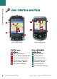
User Interface and Keys User Interface and Keys G A A G 1 4 4 1 2 2 3 5 3 6 5 6 B D C E B D F F C E Acer c500 series Acer n300 series CoPilot user interface 1 2 3 4 5 6 Next turn arrow Route ahead highlighted Driver’s current position Distance to next turn CoPilot Menu button GPS status indicator Acer n300/c500 series keys A B C D E F G 2 CoPilot Pocket PC 6 Power button Today button Calendar button Messaging button Contacts button 5-way joystick SD memory card slot Acer n300,
CoPilot uses Global Positioning Satellites (GPS) to locate your position on a map and to provide turn-by-turn guidance to a destination. GPS Set-up GPS Set-up Note: Please see instructions below for Acer n300. Please refer to page 4 for instructions on setting up Acer c510 and c530 devices.
GPS Set-up Instructions for Acer c510 and c530 The Acer c510 and c530 have an integrated GPS receiver which allows you to obtain a GPS fix so you can enjoy satellite navigation on your device. Launch CoPilot by selecting Windows Start > Programs and then select the ‘CoPilot’ icon If you have the optional GNS FM9 TMC cable, attach it now. Connecting a GNS FM9 TMC cable (by model) If you have the optional GNS FM9 TMC cable you can receive real-time traffic information via TMC.
Take a look at the CoPilot Home Screen The ‘Home’ screen is displayed when you first launch CoPilot, or it can be accessed by selecting Menu > Options > Home.
Navigating to a destination Navigating to a Destination Select ‘Going To’ from the ‘Home’ screen. In the ‘Going To’ screen, please press the ‘New Trip’ button.
From the ‘Select Stop’ screen. Press the ‘Address’ button. Using the keyboard, type in the Country, City/ Postcode, House Number and Street Name details of the destination in the appropriate screens. CoPilot may display a list of address matches. If an exact match is not found, a cross street, nearby address or a street in a nearby city will be displayed. Navigating to a destination Entering an Address Please select one of these and press ‘Next’ to continue.
Navigating to a destination Entering a Home Address In the ‘Select Stop’ screen, press the ‘Home’ button. The first time you use this button, you will be prompted to enter your home address to pre-programme this button. Enter your home address the same way you enter a new address (described on pg. 7). The next time you use the ‘Home’ button to obtain guidance to/from home to a destination, simply press the ‘Home’ button from the ‘Select Stop’ to enter it as a destination.
In the ‘Select Stop’ screen, press the ‘Favourite’ button. A scrollable list will appear, providing you with quick and easy access to your top 50 destinations. Select a Favourite from the list to enter it as a destination and press ‘Start Driving’. How to create a Favourite To add a destination to your Favourites list enter an address, in the same way you enter a new address (described on pg. 7).
Navigating to a destination Entering a Recent Destination In the ‘Select Stop’ screen, press the ‘Recent’ button. A scrollable list will appear, providing you with quick and easy access to the last 50 destinations that you entered. Note: When your Recent list is filled (50), each new address will replace an address that has been inactive for the longest period of time. Select a Recent destination from the list to enter it as a destination and press ‘Start Driving’.
Navigate to a Contact listed in your Acer's Outlook Contacts address book. Tip: use the synchronisation cable provided with your PDA to copy your Microsoft Outlook Contacts from your PC to your Acer device. Press the ‘Contact’ button in the ‘Select Stop‘ screen. Type the first letter of your Contact’s name. A list of Contacts starting with that letter will appear. Select the Contact’s name and press ‘Next’. Assign the Contact to either the Business, Home or Other Category and then press ‘Next’.
Navigating to a destination Navigating to a Point of Interest Points of Interest (POIs) are important, useful and popular locations. You can use CoPilot to locate and navigate to any one of thousands of Points of Interest. POIs are listed by category and type to assist your search. To search for a POI, select a ‘Category’ and ‘Type’ and enter a name (optional). Press ‘Next’. You can search for a POI ‘along current route’ or ‘near current location’ if you have a GPS signal.
‘Map’ to preview the location of the selected POI on a map. In the map screen, press the +/- buttons to zoom in and out of the view. Press ‘Close’ to return to the POI matches screen. ‘Expand’ to run another search within a larger search area. ‘Finish’ to enter it as a destination and select ‘Start driving’. POI Alerts To report and view POIs (by desired category) for any journey on a map while driving, select Home > Settings > POI Alerts.
Navigating to a destination Navigating to a 7 digit UK Postcode In the ‘Select Stop’ screen, press the Postcode button. Use the keyboard to enter a full UK postcode. Press ‘Next’. Enter the House Number and Street Name or simply select ‘Postcode Center’. Press ‘Next’. You will be offered the opportunity to create a name for your destination, either type in a name or leave this field blank.
In the Select Stop screen, press the ‘Pick on Map’ button. Zoom the map to a starting area by entering an Address, Favourite, Contact or POI, then select a location on the map. To help you find your desired location you can pan around the map by tapping the map screen and moving it with your stylus. Additionally, press the +/- buttons to zoom in and out of the preview. Navigating to a destination Pick on Map You can enter a destination by selecting a point on a map and pressing ‘Add as Stop’.
Navigating to a destination Navigating to an Intersection To enter the intersection of two roads, press the ‘Intersection’ button in the Select Stop screen. Use the keyboard, to enter the Country. In the following screen type in the City/Postcode. Enter the name of the “First Street”. Press ‘Next’. Enter or select from the list the name of the “Second Street” which intersects the “First Street”. Press ‘Next’.
In the ‘Select Stop’ screen, first press the ‘More’ button then select the ‘Lat/Long’ button. Select a metric from the drop-down pick list and then use the keyboard to enter the latitude/longitude points. Press ‘Next’. You have the option of naming the destination. Press ‘Next’. Navigating to a destination Latitude/Longitude The latitude/longitude points will be entered as a destination. Press ‘Start Driving’.
Navigating to a destination Saved Trip In the ‘Select Stop’ screen, first press the ‘More’ button then select the ‘Saved Trip’ button. You can save a trip by entering a destination or multiple destinations in the same way you enter a new address (described on pg. 7). Once you have finished entering your complete itinerary, select ‘Menu > Trip > Save Trip. Enter a name for this itinerary and press ‘Apply’.
Editing your planned journeys in CoPilot The ‘Going To’ screen displays the destination(s) entered for your journey. Press Menu > Trip > Edit to display this screen from the guidance screens at any time. From the ‘Going To’ screen you can edit the current trip, add additional stops, or start a new trip.
Optimising and re-arranging stops Optimising and re-arranging stops Optimising your journey CoPilot can work out the best way around multiple destinations for journeys that require you to stop/pass through various locations. Note: You must have at least three destinations entered in the ‘Going To’ screen to optimise your journey. Simply enter the destinations in the ‘Going To’ screen. To optimise your stops select any destination on your itinerary and press ‘Optimise Stops’ from the pop-up menu.
Once you have entered your destination(s) in the ‘Going To’ screen and selected ‘Start Driving’, CoPilot will calculate the best route and provide you with turn-by-turn guidance to the destination(s). Detour Feature Detour Feature While driving along your route, if you face unexpected traffic congestion, road works/closures or any other unforeseen circumstances that causes delay along your route, you can use CoPilot’s detour feature to calculate and preview an alternative route.
Selective Routing Selective Routing You can choose to avoid specific roads in the automatically calculated itinerary or adjust the route using waypoints. 1) Customise your Trip Itinerary Set CoPilot to Guidance Mode by selecting Menu > Mode > Guidance. Enter your destination(s) and press ‘Start Driving’. Press Menu > View > Itinerary to display the itinerary map which shows all road names, turn instructions and the distance between each turn.
Traffic incidents are reported in real-time into CoPilot using a TMC data feed. Note: To use the optional TMC traffic service, you must have a compatible TMC receiver, otherwise you will be unable to use this service. TMC Traffic Service TMC Traffic Service* Setting up the TMC Traffic Service 1. Set-up your a GNS FM9 TMC cable to obtain a TMC signal, as described on page 4 . 2. TMC is set as a source for traffic information. By default, tuning is set to automatic. 3.
TMC Traffic Service How to use the TMC Traffic Service In Guidance Mode, press Menu > Traffic > Find Traffic to search for all traffic incidents broadcasted over the air. Alternatively, press Menu > Traffic > Check Route to view traffic incidents reported along your current route. A list of reported traffic incidents will be displayed in the ‘Traffic’ screen. Highlight and select a traffic incident to open a pop-up menu which offers you 4 options: 1.
CoPilot has six different driving views which can be accessed by pressing Menu > View. Driving Views Driving Views Where am I? Driver safety 3D Itinerary Next turn Destination To change driving views press Menu > View and select a driving view from the drop-down menu. Driver Safety Driver Safety is the default view, which displays a simple turn instruction arrow with concise next turn instructions. An auto-zoom map will appear as you approach a turn or if your speed is below 10 mph.
Driving Views Where am I? Destination Allows you to see your current position on a map. It combines a large 2D map display with concise text instructions. Displays your current position on a map and highlights the route to your next stop symbolised by a flag. Itinerary 3D Enables you to view detailed turn by turn instructions for your trip. Allows you to see your current position on a map in threedimensional perspective.
Trust your CoPilot to guide you to the door at night - safely and in comfort. CoPilot’s night mode uses the time set on your Acer device to automatically display night time 2D or 3D maps to reduce glare and eye strain while driving using CoPilot at night. Driving Views Day/night map display To set-up night mode select, Home > Settings > Map > Map Colors > Automatic Day/Night Mode.
Navigation Modes Navigation modes CoPilot has 3 navigation modes, accessed by selecting Menu > Mode. 1) Guidance Mode provides spoken and on-screen driving directions plus other information relevant to your journey such as Estimated Time of Arrival (ETA), road name of the next turn and the distance to turn. 2) Planning Mode lets you plan your journey in advance. Simply key in a destination and view the itinerary and detailed street maps of any location - wherever you are.
Select Home > Settings > Routing (or Menu > Trip > Settings > Routing) to change settings that affect CoPilot routing options. Routing Settings Routing Settings 1. Basic Routing Options Vehicle type In the Routing screen, the vehicle type options are ‘Automobile’ or ‘RV’. RV routes favour major roads and avoid sharp turns and U-turns wherever possible.
Routing Settings London congestion charge warnings If you are driving in London, you can set up CoPilot to alert you when your destination approaches/passes through the London Congestion Zone. You will have the option to either drive through the charging zone or re-route around it. To set-up London Congestion Zone alerts, select: Home > Settings > Routing (or Menu > Trip > Settings > Routing) and then select the London Congestion Zone Warning tick box. Press ‘OK’.
Select Home > Settings > Guidance (or Menu > Trip > Settings > Guidance) to change settings that affect CoPilot guidance options. Guidance Settings Guidance Settings Speak Turning Warning Just Ahead Custom display option Speak Turn Warning Set CoPilot to provide voice guided instructions when you approach a turn. Select one or all of the distance tick boxes to receive voice guided turn instructions. Just Ahead CoPilot will alert you with a voice instruction before you reach every turn.
Guidance Settings Display route arrow Amplify speech volume Display GPS arrow trail Display route arrow A yellow turn arrow will be displayed in CoPilot’s guidance maps to indicate the direction of your next turn. By default, this option is turned on. Select and untick the ‘display route arrow’ for this yellow instruction arrow NOT to appear in CoPilot’s guidance maps. Amplify Speech Volume If you would prefer the CoPilot voice instructions to be amplified, select the ‘amplify speech volume’ tick box.
Select Home > Settings > Map (or Menu > Trip > Settings > Map) to change your map settings. Map Settings Map Settings Unit for measuring distance Map rotation Stylus control POI settings Units Set the unit for measuring distance as either ‘miles’ or ‘kilometres’. Map Rotation CoPilot will display the driver’s position on a map in one of the following orientations: 1. Heading up - the driver’s position will always be reported moving up the map towards the destination 2.
POI Alert Settings POI Alert Settings POI Alerts To report and view Points Of Interest on a map, select Home > Settings > POI Alerts (or Menu > Trip > Settings > POI Alerts) then select the ‘Enable’ tick box. POI Alerts Report POI this far ahead Message timeout Report and select POIs Reporting POIs Define the distance ahead that POIs are reported along your route, using the distance pick list. Set CoPilot to report POIs which are actually ‘on route’ or ‘near route’.
Language and Speech To change your language settings, press Home > Settings > Language and Speech (or Menu > Trip > Settings > Language and Speech then select your desired language* from the picklist: US English UK English German French Spanish Italian Dutch Swedish Danish Portuguese Norwegian Finnish. Language and Speech Settings Language and Speech Settings *CoPilot supports the languages available for the picklist.
Favourite Settings Favourite Settings To change your ‘Favourite’ destinations created and saved in CoPilot, select Home > Settings > Favourites (or Menu > Trip > Settings > Favourites). Favourite Home Edit Work Delete Delete All Add to favourites In the ‘Favourite’ settings screen a list of all your favourite destinations will be displayed. To delete a ‘Favourites’ destination, select a destination and press ‘Delete’.
To change your ‘Recent stops’ visited select Home > Settings > Recent Stops (or Menu > Trip > Settings > Recent Stops). Delete Delete All Add to Favourites Recent Stop Settings Recent Stops Settings To delete a ‘Recent’ destination, select the destination and press ‘Delete’. To delete all ‘Recent’ destinations press ‘Delete All’ and select ‘Yes’ when prompted to confirm the deletion. To add one of your ‘Recent’ destinations to your ‘Favourites’ list, select the destination and press ‘Add to Favourites’.
Options Menu Options Menu Select, Menu > Option to access the following: Help CoPilot has a help function, which provides you with instructions and information about setting up and using the software. Select Menu > Options > Help. Tutorial Follow CoPilot’s tutorial to help you get started. Learn how to enter a destination to start navigating. About Read about the version of your CoPilot license. Licensing Provides details of the status, license number and validity period of your CoPilot license.
www.alk.eu.com ht © 2 006. ser hts re ALK Tec hnologies Ltd. All rig . ved CoPilot Desktop Software and Customer Support CoPilot Customer Support For telephone and email technical support for CoPilot, please visit www.alk.eu.com/acer for more details. CoPilot Desktop Software Please use the supplied desktop CDs if you need to re-load your storage card with CoPilot.
CoPilot Desktop Software Installing CoPilot Pocket PC 6 desktop software Please follow the step by step instructions below to install your CoPilot Pocket PC 6 desktop software. 1. Please insert the disc labelled ‘Install Disc - Europe’ into your desktop computer/laptop CD drive. 2. Select ENGLISH [UNITED KINGDOM] as your preferred language. Press ‘OK’. 3. The InstallShield Wizard will install CoPilot Pocket PC 6 on your computer/laptop. Press ‘Next’. 4.
You may need to download the CoPilot Quickstart application if your storage card becomes corrupt or if you have purchased an European maps upgrade. How to perform a Data Download Wizard (DDW) Data Download Wizard Data Download Wizard Stage 1 - Specify where data will be stored 1. Launch CoPilot Pocket PC 6 on your desktop computer/ laptop. Select Start > Programs > CoPilot - Pocket PC 6. 2. A ‘Data Download Wizard’ dialogue box will be displayed on launching CoPilot. 3.
Data Download Wizard 42 The location entered will be displayed on the map, press ‘OK’. Using your mouse, draw a box to select your desired map data area. The map area selected will be highlighted yellow. 3. Region - Select the region icon to download map data for a whole country or region. In the ‘select a country or region’ dialogue box, please select the UK [UNITED KINGDOM] tickbox and press ‘Next’.
Acer n300, c510 and c530 Edition CoPilot Pocket PC 6 Data Download Wizard Stage 3 - Transferring the data to your Acer device If you have downloaded the data directly to the storage card in your storage card reader, please follow the instructions below: 1. Close all windows on your desktop computer/laptop 2. Remove the storage card from the storage card reader 3. Insert the storage card into the SD memory card slot of your Acer device. CoPilot will now install automatically.
www.alk.eu.