TOCLS-OE100 TOCLJ-OE100 Owner’s Manual Navigation
Preface NavMate navigation software provides turn-by-turn route guidance while traveling to your destination. Before operating, take a few minutes to review the safety and operating instructions in this manual so you can quickly and safely become familiar with your NavMate software’s many features.
End-User License Agreement This End-User License Agreement (EULA) is a legal agreement between you (either an individual or a single entity) and HORIZON NAVIGATION, INC. for the operating software and updates thereof that run the digital map database and associated hardware (collectively the “Software”). By installing or using the Software, you agree to be bound by the terms of this Agreement.
Contents PREFACE. . . . . . . . . . . . . . . . . . . . . . . . . . . . . . . . . . . . . . . . . . . . . . . . . . . . . . . . . . . . . . . . . . . 2 SAFETY INFORMATION AND PRECAUTIONS. . . . . . . . . . . . . . . . . . . . . . . . . . . . . . . . . 6 INTRODUCTION TO YOUR NAVMATE SOFTWARE. . . . . . . . . . . . . . . . . . . . . . . . . . . . . 7 VEHICLE POSITION . . . . . . . . . . . . . . . . . . . . . . . . . . . . . . . . . . . . . . . . . . . . . . . . . . . . 7 MAP AND INFORMATION DATABASE. . . . .
Contents EDIT TRAIL BOOK. . . . . . . . . . . . . . . . . . . . . . . . . . . . . . . . . . . . . . . . . . . . . . . . . . . . . . . . . . . ADD TRAIL. . . . . . . . . . . . . . . . . . . . . . . . . . . . . . . . . . . . . . . . . . . . . . . . . . . . . . . . . . . . EDIT TRAIL. . . . . . . . . . . . . . . . . . . . . . . . . . . . . . . . . . . . . . . . . . . . . . . . . . . . . . . . . . . . SETUP TRAIL DISPLAY. . . . . . . . . . . . . . . . . . . . . . . . . . . . . . . . . . . . . . . . . . . . . .
Safety Information and Precautions WARNING! Please read and follow the following safety precautions. Failure to follow the instructions below may increase your risk of collision and personal injury. The Please Drive Safely screen is displayed each time the NavMate software is turned ON as a reminder to make use of the system’s navigational aids in a safe manner. Before using the NavMate software, read this entire manual.
Introduction to Your NavMate Software NavMate software provides turn-by-turn visual and voice assistance to direct you to your selected destination. The software quickly calculates step-by-step directions to any destination available on the included navigation map. The NavMate software uses Global Positioning System (GPS) satellites, and a digital roadway map database to calculate and display travel directions.
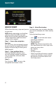
Quick Start QUICK START Step 4 -- Select Destination Follow these four easy steps and you are You have many ways to select a destination. For this example, let’s find a nearby on your way. Airport. NOTE: Before operating your NavMate Select by touching screen: software, please carefully read and follow the instructions provided in the “Safety Information and Precautions” • Icon to activate main menu. section of this manual.
Quick Start Step 5 -- Map/Guide along Route Proceed to the highlighted route and drive while the NavMate software provides audible and visual guidance to your destination. Step 6 -- Arrive at Destination That’s it! You’ve arrived at the selected destination. Refer to the rest of this manual to become more familiar with the many options available on your NavMate software.
Using Your Software The best way to learn about this product is to use it, while observing the safety precautions discussed earlier. Function Buttons The buttons on the bottom of the display are called function buttons. These buttons change labels and function depending on the screen displayed. The list below provides a brief description of the function buttons.
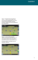
Navigation Menus Main Menu Screen This screen illustrates the Main Menu options available when the icon is pressed. Main Menu Options Select this Option to... Home Address Route to home address Go to...
Selecting Destination There are five ways to select a destination: 1. Address and Intersection 2. Point of Interest (POI) 3. Favorites 4. Coordinates 5. History Several of the methods allow you to move through a list by scrolling using the page up or down keys or by searching using an on screen keyboard (Spell Mode): Many of the lists keep track of the last five most recently used selections (history). This list allow you to quickly select items that are used frequently.
Navigation Menus Keyboard Screen Buttons Button Press This Button To... Delete last entered character Select currently input characters and show list of matches Switch keyboard from QWERTY layout to special character layout Switch keyboard from special character layout to QWERTY layout Quit Spell Mode and return to List Mode Map Mode Screen Buttons The table below explains the button functions available on the Map Screen. Button Press This Button To...
Destination Selection (Go To...) Destination Selection (GO TO...) To select a destination, you must select “Go To…” from the Main Menu. Destination Selection Buttons The table below explains the button functions available on the Map Screen Address/Intersection Button Press This Button To...
Destination Selection (Go To...) Postal/City/Street/Intersection: You may select either the Postal code or City Name or the Street Name first. NOTE: When the icon is pressed, the icon will change to the next category (Postal, City, or Street) • Postal Code icon – If you know the postal code, select this option to quickly find the city. NOTE: The postal code search is limited to the currently selected State/Province. Postal code searching may not be available in all areas.
Point of Interest (POI) The Point of Interest option is useful when you are going to a public place or are looking for some type of facility such as a gasoline station. Select “Go To” from the main menu. Then select “Point of Interest” from the Go To Screen. After selecting the Point of Interest option, you must select the State/Province where the destination is located. NOTE: The system remembers the last State/Province selected, so this step is not necessary every time.
Destination Selection (Go To...) POI Search Results Some POI categories may not be available in some areas and not all possible POIs may be listed for all categories. For example, although the “Restaurant” category is very extensive, it is only as current as the map database information. Several categories restrict the search radius as well to minimize the search time. Since businesses change over time, so will the accuracy of the points of interest in your navigation map.
Home Address The Home Address is a convenient way to route to your saved home address directly. Office Address The office Address is a convenient way to route to your saved office address directly. Favorites There are three additional ways to set your destination under Favorites: Address Book The Address Book is a convenient place to store frequently visited destinations. To add, delete, or edit address book entries see “Edit Address Book” section of this manual.
Destination Selection (Go To...) Address Book Entries Screen This screen illustrates the address book screen and the selection options. Address Book Selection Buttons Button Press This Button To...
Coordinates You can route to a destination by directly inputting latitude and longitude values. History Previous destinations entered into your NavMate software are automatically saved into the memory of the NavMate software. This is helpful when you want to return to a recent destination, such as a hotel where you may be staying. The Previous Origin of the last calculated route is also stored for easy return to your start point. Previous Destination Selection Buttons Button Press This Button To...
Destination Selection (Go To...) By using Map You may select the destination by touching the screen. The system will display the cross hairs according to the location you touch. Press current position icon to display location information about the current panned location. Select the highlighted entry to select the panned location for the following options. Quick POI These points of interest are located in close proximity to the area selected on the map screen.
Route Guidance and Map Route Calculation and Guidance After selecting a destination, the system calculates a route based on the route criteria set in the Setup Menu. The Status Bar indicates calculation progress. Please Proceed When route calculation is complete, the NavMate software will instruct you to “Please proceed to the highlighted route” unless you are already on the route. The highlighted route is indicated in yellow.
Route Guidance and Map True View (Intersection Zoom) Just before a turn point, the guidance display will show a close-up or “true view” of the roads around the turn point. Map Display The Map Display shows roads, road names, and cartographic features like lakes and rivers. You can adjust the map scale, the map orientation, map view, status information display, and the distance units to your own preferences (See Setup section of this manual).
Current Location Screen Press current position icon to display information about the current map location. Then select the location information box to add it to address book, use it as a destination, re-set position, or save location as HOME location. Arrival Screen The destination is shown on the Map Display screen with a circle. A voice message announces that you are approaching your destination.
Edit Address/Trail Point Select “Go To” from the Main Menu. Then select “Favorites” from the “Go To” screen. Edit Favorites Menu Add or modify destinations in Address Book, Home Address, Office Address, Trail Book and Trip Book. Edit Address Book The “Address Book” option allows adding and editing address book entries. Select “Edit Favorites” from the Main Menu then select “Address Book”: Use Edit function to rename address book entry and to delete.
Edit Home Address The “Home Address” option allows adding or replacing of the home address. Select the home address from the following menu locations. Edit Office Address The “Office Address” option allows adding or replacing office address book. Select office address from the following menu locations.
Edit Address/Trail Point Edit Trail Book The “Trail Book” option allows adding, editing and Setup display for trail book entries. Add Trail Press current position icon a waypoint. Press Menu icon to add and select “Stop Trail” when you complete the trail.
Edit Trail The “Trail Book” option allows adding, editing and Setup display for trail book entries. Select the trail name, use to rename the trail and to delete the trail.
Edit Address/Trail Point Select the highlighted trail name to edit color and waypoints. Use to rename the waypoints and to delete the waypoints.
Setup Trail Display Select Setup Display and set the map scale for the trails to be displayed.
Edit Address/Trail Point Edit Trip Book Edit Trip Book allows adding and editing trips and destinations within a trip. Add Add allows adding trips and destinations within a trip. Press to add additional destinations to the trip, press to rename the destinations and press to delete an existing destination in a selected trip.
Edit Edit allows modifying destinations within a trip and or deleting an existing trip. Press to rename the highlighted trip and press to delete the trip. Edit My POI The user can create personalized Point Of Interest categories.
Edit Address/Trail Point Add Category In order for My POI to work properly, a category needs to be created first. POI. Use the keyboard to create a new POI category name and set icon, sound and distance of your choice to the created category. Then add the destination as a POI. By selecting sound and distance the system will alert you when you are approaching the POI destination.
Setup Display By selecting the map scale, the user can hide or display the POI on the selected map scale view. Edit Category The user can modify or delete the selected POI category. Press press 34 to rename the POI category or to delete.
Edit Address/Trail Point Add to My POI By selecting a destination, the user can add this destination as a POI to the POI category previously created. Edit My POI The user can modify the POI items by category, by name or by phone number. The POI names can be edited or deleted from the list. Setup Menu You may customize the NavMate software to your own preferences. Select the Setup option to adjust navigation preferences, display options, and units (km or mi) settings.
Preferences Setup Routing Criteria Navigation Preferences allows you to enable the simulation mode, set the route calculation and guidance options. • Simulation On/Off – When On, the NavMate software will “drive” the selected route even though the vehicle is not moving. This can be used to preview a route, or demonstrate the system to friends. • Shortest time/distance – Determines if the NavMate software emphasizes finding the fastest or the shortest route.
Preferences Display Options Display options allow you to set the map orientation and some of the information items displayed. • North Up/Heading Up – Determines if the map is always displayed with North direction at the top of the screen or if map is always adjusted so that vehicle symbol points toward the top of the screen. • Display Clock – Turn the display of the clock on or off. • ETA – Turn the estimated time of arrival function on or off.
User Preference Settings NOTE: The term”TTS” refers to the text to speech function.
Preferences Day/Night Settings You can select Auto, Day or Night color scheme. Point of Interest This feature will allow you to select POI that will be displayed in different scales. Point of Interest Icon Type This screen appears after an item is selected from the POI Icon Setup Screen. Location Reset You may reset the location of the vehicle symbol using the Location Reset option.
System The System menu allows you to set the volume, display the GPS reception status and provides information on the current software and map version numbers. Volume Allows the user to set or mute the volume of the navigation unit. GPS diagnostic The GPS diagnostic displays the number of GPS satellites currently in view and how many are currently being used. The GPS satellite time is displayed Universal Time Coordinated (UTC) and so is the latitude and longitude determined from GPS.
Preferences Trip Computer Trip Computer displays speed, trip related timing, elevation, odometer and clock. Press to display detailed reading of each field. Scroll the Up or Down arrow button to choose the field then press to refresh current reading.
Planned Route View the planned route on a highlighted route by clicking the top left corner icon (arrow). The system will display the entire route list.
Preferences Avoid Specific Road Cancel Route Select this function to cancel the current route.
Trail Book Follow Trail Next time when you go off-road, you can follow the same trail you created by selecting “Start Route Guidance” then select “Trail Book” and finally select an existing trail. Select the Trail Book icon. The following screen appears upon selecting a trail.
Trail Book You can select to go to any points in this trail as a starting point. Upon your selection, the system will point you with a red line to that starting location. You will follow the red line to the starting point and start your trail by following the dotted line. Press Menu icon and select “Stop Trail” to cancel route.
SOFTWARE UPDATE FUNCTION The navigation software contained in the DVD must be transferred to a USB thumb drive that is at least four gigabytes or more. To update navigation software, press the unit’s front panel or front remote control MENU button and select SETUP. The following screen will appear: The navigation software upgrade USB device should connected to the iPOD Interface USB port.
Update Software When the unit has completed the search for updated files one the following screens will appear: If a new version of the navigation software is found, pressing the YES icon will cause the unit to extract the software from the USB device and update the navigation software. Press the NO icon and the unit will return to previous mode prior to the upgrade. CAUTION: The navigation software update can take up to one hour to complete. During this time the unit must not be turned off.
C 2009 Audiovox Electronics Corp.