
Operator`s manual

PFadvantage
Boundary
Ag Leader Technology
All Modes
September 2003
4-55
Introduction
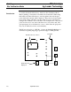
Using the GPS receiver, you can create a boundary file in any mode by
driving around the outside of the field. If you create a boundary for all your
fields and always keep the boundary files on your memory card, you will
see the field boundary appear on the on screen map when you press SHOW
MAP key. This is useful because you can show a map of where you have
driven and a map of the field boundary at the same time. Boundary files are
required to grid a field.
Boundary files are stored as *.BDY files on the card. Only one boundary
file can be selected and displayed for a field. Sub boundaries can not be
created or displayed for a field.
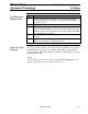
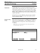
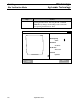
Boundary Setup
Screen
With a card inserted into the monitor, press MENU key until OPTIONS is
displayed and press BOUNDARY key. Press the EDIT key to change to a
different field from the one being viewed. After selecting the field press
ACCEPT key.
NOTE: The area count switch must be in the down position before
entering boundary setup screen.
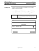
BOUNDARY SETUP
Field F1:
Current Boundary None
Created On 02/10/99
EDIT
CREATE
BOUNDARY
CANCEL