
Technical data

Chapter 14 399
Return Loss
Measuring Return Loss
Return Loss
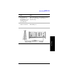
Displaying Location Information Using GPS
If you are making a Return Loss measurement, you may use GPS Location data to
verify your location. For additional information on the GPS Data function, refer to
“Displaying GPS Location Data” on page 462.
To Display GPS Location Information:
NOTE If you prefer to have an electronic copy of the location information, see “Saving
Data” on page 469.
6 Locate the marker relative to the trace:
• [Marker to Peak]
• [Marker to Next Peak]
[Marker to Next Min]
This feature is available for
both normal markers and for
delta markers.
Step Notes
1 [Level/Location]
2 On [Show GPS
Location] select
On.
Displays GPS satellite location information. Uses the
internal GPS to capture the location of a
measurement. The GPS information can be used to
return to the same location. The Time Ref
(Freq/Chan/Time Ref mode) button must be set to
Internal GPS for this function to be active.
Information logged includes longitude, latitude,
altitude (feet/meters), and the number of satellites
tracked.
Each time you press this softkey, the selected option
changes.
3 Highlight [On] Toggle to [On] to display GPS satellite location
information. Toggle to [Off] to remove the location
information
Step Notes