
Technical data

74 Chapter 3
1xEV-DO Analyzer and Over Air Test
Displaying Location Information Using GPS
1xEV-DO Analyzer and Over Air
Test
Displaying Location Information Using GPS
If you are making 1xEV-DO over air measurements at a location you previously
established as valid, Agilent recommends using GPS to verify that you are at the
location from which you previously measured.
If you are making 1xEV-DO over air measurements from a new location, once you
validate that the location provides a dominant pilot and low multipath power,
Agilent recommends that you record the latitude and longitude coordinates of this
location using GPS. Later measurements should be made from this precise location
to provide performance trends.
For additional information on the GPS Data function, refer to “Displaying GPS
Location Data” on page 462.
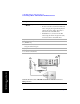
To Display GPS Location Information:
NOTE If you prefer to have an electronic copy of the location information, see “Saving
Data” on page 469.
Step Notes
1 [Level/Location]
2 On [Show GPS
Location] select
On.
Displays GPS satellite location information. Uses the
internal GPS to capture the location of a
measurement. The GPS information can be used to
return to the same location. The Time Ref
(Freq/Chan/Time Ref mode) button must be set to
internal GPS for this function to be active.
Information logged includes longitude, latitude,
altitude (feet/meters), and the number of satellites
tracked.
Every time you press [Show GPS Location], the GPS
location display alternates between On and Off.