740 User’s Guide
Welcome Thank you for choosing PC*MILER Navigator. This guide will tell you everything you need to know about using PC*MILER Navigator SAFETY NOTE: PC*MILER Navigator powered by CoPilot Truck is designed to calculate the most efficient and truck-specific route for you. However, some of the information in the database may change from time to time. You must stay alert and pay attention to road signs at all times.
Contents Getting Started 6 - 12 Checklist Identification To Assemble the Windshield Mount To Attach the Truck Charger To Attach the Home Charger Switching On and Off Preparing PC*MILER Navigator Select Language and Voice Select a Distance Measurement Tips and Tricks In Use 7 8 9 9 9 10 10 10 11 12 13 - 34 GPS Startup Selecting a Destination Pick a Stop From the Map Nearby Points of Interest Adjusting the POI Settings POI Search To Choose a Recent Destination To Delete the Recent Stop
Contents On Screen Information ETAs and Distances Personalize Driving View Driver Safety 3D 2D Where am I? 2D Next Turn 2D Destination Itinerary Night Mode Saving a Destination as Home Saving a Destination as Work Changing Your Work or Home Save Your Favorite Destinations Edit or Delete Favorites Night Mode Customizing the Guidance Screen Setting Map Preferences Setting Map Styles Personalizing the Voice Instructions Time Zone Advanced Setting Route Preferences Saving a Routing Pro
Contents Playing a Demo Adjusting Keyboard Settings Adjusting the Volume About CoPilot Licensing PC*MILER Routing Types 58 59 59 60 60 61 - 67 Practical Routes Economic Routes Shortest Routes National Network Routes 53 Foot Trailer Routing Heavy/Light Vehicle Routing (Override Restrictions) Toll Roads International Borders Open Hazmat Routing Hazardous Material Route Types & Road Categories 61 61 62 62 64 65 66 66 66 67 Icon Legend 70 Support 72 End User License Agreement 73
Getting Started FOR YOUR SAFETY It is your sole responsibility to use the product in a safe and responsible manner. You must obey local traffic laws, posted road signs and safety regulations. Do not operate the product while driving. ALK shall not be liable for any errors or omissions of either the map data or truck restrictions data contained in the product. You agree that the map data, the truck restrictions data and the routing may not be accurate.
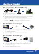
Getting Started Checklist Check the contents of your box, box should contain: • PC*MILER Navigator with Pre-installed CoPilot Truck GPS Navigation Software • QuickStart Guide • User Manual • Windshield Mount • Truck Charger PC*MILER Navigator • Home Charger Quick Start Guide and User Manual Windshield Mount Truck Charger Home Charger User’s Guide 7
Getting Started Identification Reset Button SD Logo is a trademark.
Getting Started To Assemble the Windshield Mount • Attach clip to mount. • Place mount against windshield. • Before attaching to windshield ensure lever is in unlock position (away from suction cup toward clip). • Put suction cup on windshield and press lever into lock position (down toward base of mount) to secure. To Attach the Truck Charger • Connect USB end of charger to the USB port on the PC*MILER Navigator. • Connect opposite end into truck power port.
Getting Started Switching On and Off • Switch on PC*MILER Navigator. Hold down the power button for 3 seconds to turn the PC*MILER Navigator on. • Switch off PC*MILER Navigator. Hold down the power button until unit displays ‘Powering Off’. Preparing PC*MILER Navigator The CoPilot Truck GPS Navigation software with street-level maps of United States and Canada are pre-installed on your PC*MILER Navigator device. No additional installation necessary.
Getting Started Select a Distance Measurement • Choose between Miles and Kilometers (km) for distances. Tap NEXT. • You will be asked to accept the Safety Warning for PC*MILER Navigator. Tap Accept to continue.
Getting Started Tips and Tricks PC*MILER Navigator is full of great features. To help you get to know them, we have included Tips and Tricks at start up. To Turn off Tips and Tricks uncheck the ‘Show Tips and Tricks’ box. To see more use and . To close the window tap on .
In Use GPS Startup The PC*MILER Navigator has an integrated GPS receiver. The first time you use the Navigator, the GPS receiver will take up to 10 minutes to determine your position. To ensure ETA to your destination is accurate, select the correct time zone on your device. • Select Menu > Settings > > > Time Zone. • Select the time zone of your current location. Tips: GPS Signal GPS Signal will be limited inside buildings, tunnels, or parking garages.
In Use Selecting a Destination PC*MILER Navigator uses GPS Satellites to calculate your exact position so you don’t have to enter your starting point. Simply enter your destination and PC*MILER Navigator will take you there, providing detailed dock-to-dock voice guided instructions. • Tap Menu > Destination > Address. • Enter the city/town name of your destination. • Select the correct city or area when it appears in the list below the city field.
In Use A screen will then appear, showing you a map of the route. Select Drive to begin navigating your route. NOTE: Your routing profile contains information about your truck’s dimensions, weight, and NEW SCREEN SHOT COMING hazmat restrictions. You may tap the Routing button on this screen to set rputing information (see page 48 for setting route preferences). Pick a Stop From the Map You can also select a destination from the map. • Tap on Menu > Destination > > Pick on Map.
In Use Nearby Points of Interest If you are running low on diesel fuel or need to rest at a truck stop, PC*MILER Navigator has millions of pre-loaded Points-of-Interrest (POI) to search. • Tap Menu > Nearby POI • From the list, select a category. For example Truck Services. After a few moments a list of nearby Truck Services will appear, shown in order of distance from your current location. • Select truck service by tapping desired truck service name. • Tap Add Stop.
In Use Adjusting the POI Settings You can choose to have POIs shown on-screen and the distance at which you are notified by adjusting the POI settings. • Tap Menu > Settings > > POIs. • To activate notification of the upcoming POI’s along you route tap Enable, then check box in POI Alerts. • Choose to show POIs Always, Never, or When Stopped from the drop down menu. Tap to show options and tap desired option. • In the Report POIs this far ahead field, select a distance between 0.
In Use POI Search If you want to find a specific POI without knowing the address, you can search the POI database and set it as a destination. • Tap on Menu > Destination > Points of Interest. • Choose to select Any Category or Pick a Category. If you check the Pick Category box, tap the correct category. Then tap Next. • If you check Any Category (any category will bring up a list all POI categories to choose from), tap Next.
In Use • If you select In a City or Near an Address enter the name of the city or town nearest the POI you are searching. PC*MILER Navigator will then search the millions of POIs in its database. When complete, a list of the nearest matches will appear on-screen. • Select POI by tapping desired POI name. • Tap Details to view the POI on the map. PC*MILER Navigator will display the phone number for the POI (if available).
In Use To Delete the Recent Stops List • Select Menu > Destination > > Recent > Clear All. To Choose an Intersection for Your Destination • Select Menu > Destination > > Intersection. • Enter the City or Town (see page 14). • Enter the first road. • Enter the second road. If you are not certain of the second road name PC*MILER Navigator will provide a list of intersecting roads from which to choose.
In Use Selecting a Destination using Latitude and Longitude If you know the latitude and longitude of your destination you can enter them directly. • Select Menu > Destination > > Coordinates. • Choose to set the latitude and longitude in either Degrees Minutes Seconds, Decimal Degrees or Decimal Minutes (selected on the previous screen). • Enter a latitude and longitude in the previous format. Tap Finish PC*MILER Navigator will take a few moments to find the point.
In Use If you are outside and have a GPS fix, you can save your current location. • Select Menu > > Save Current Location. • Enter a name for the destination and tap Save. The location will be saved in your Favorites list, where it can be accessed as a destination in the future. Using Favorites to Select a Destination You can save locations such as Home and Work as well as save your Favorite destinations so you can access them quickly, (see page 39-41).
In Use • Tap Menu > > Plan or Edit Trip. • Tap Add Stop then tap desired category listed, for example Address. • Add the first address in the same way as detailed above; see Selecting a Destination on page 14. • Repeat these steps to add additional destinations. Customize Your Trip When you have entered all your destinations you can change the order they appear in. • Tap the address you wish to move.
In Use Setting Waypoints PC*MILER Navigator can route you through a certain point without considering it as a stop. By setting Waypoints you can adjust PC*MILER Navigator’s route, to calculate a detour via the waypoint. • Select Menu > > Plan or Edit Trip. Enter the waypoint address or place in the same way detailed in Selecting a Destination on page 14. Tips: Show on Map If you select Show on Map from the popup menu, a map of the area around the selected stop will be displayed.
In Use • Tap the address and a pop-up menu will appear containing a list of options. Tap Set as Waypoint. The address will now be listed as a Waypoint, with an arrow icon rather than a stop to indicate that it is a Waypoint. Tip: Make a Waypoint a Stop To change a Waypoint back to a Stop, tap the address and select Set as Stop from the pop-up menu.
In Use Saving Destination to Favorites Addresses listed on the trip can be saved as Favorite destinations so you can access them quickly. • Tap on the address you wish to save as a favorite. • A pop-up menu will appear containing a list of options. Tap Add to Favorites. Tip: Do More with Favorites See page 41-42 for personalization.
In Use Saving a Planned Trip When you have finished entering all your addresses, you can save your trip to access at a later date, rather than start driving right away. • Tap Save Trip. • Enter a name for the trip you are saving. • Tap Save and the trip will be saved to the device memory. Loading a Saved Trip • Tap Menu > > Plan or Edit Trip > Load Trip The last trip you planned will automatically load. If you wish to load an older trip, tap Load Trip and select the trip you wish to load from the list.
In Use Deleting a Planned Trip • Tap Clear. You will be asked to confirm this selection. To continue with deleting the trip tap on Yes in the Are you Sure? window. Tip: Alternatively you can select Menu > Clear Destination Preview Your Route When all your stops have been entered, tap Calculate. A route screen will appear, with a preview map of the route. Options Include: • Edit • Routing • Drive • Preview Select Routing to set the routing options for your trip.
In Use • Toll Roads: Select whether you want PC*MILER Navigator to Use toll roads, Always Avoid or Avoid if Possible. • Choose from routing profile you previously saved or Default for PC*MILER-based truck routing. Your routing profile contains information about your truck’s dimensions, weight, and hazmat instructions (see page 48 for setting route preferences). • Select the check box if you would like to display the routing options screen each time you add a destination.
In Use From route screen Select Preview to see the Preview options for your trip • Route Demo: See a preview of your trip, including instructions (see page 58-59 for instructions on playing your demo). • Turn Maps: Display a map for each turn of your trip. You can choose to see Next or Previous turn. Tap Close to exit. • Itinerary: Shows each direction in a written list with distance to each turn. Tap Close to exit. From route screen select Edit to adjust your planned trip.
In Use Begin Driving From route screen select Drive to begin navigating your Route. Editing a Trip Once you have selected Drive, you can change the trip entered by selecting: • Tap Menu > > Plan or Edit Trip. Starting Point If you are planning a trip in advance and are not at the starting point of your trip PC*MILER Navigator will ask you to select your starting location. You can choose to navigate to the starting point, or to navigate directly to the destination from your current location.
In Use Guidance PC*MILER Navigator will guide you to your destination with clear on-screen and spoken instructions. Whenever you are approaching your next turn, PC*MILER Navigator will speak to you to alert you to the upcoming direction change. In the default mode, your screen will look like the one below.
In Use On Screen Information By default your current location is displayed at the bottom of the map. You can choose what useful information is displayed at the base of your screen when you are driving, see Customizing the Guidance Screen (page 44-45).
In Use ETAs and Distances The estimated time of arrival (ETA) and the distance remaining are displayed on the right of the screen, no matter which driving view you have selected. Tip: Take a Closer Look Use the and in 2D or 3D driving views to zoom in or out of the map view.
Personalize PC*MILER Navigator can be customized to meet your individual needs and style. Driving View You can choose from six different screen displays. To access • Tap Menu > > Driving Views or tap the (driving views shortcut button) to quickly access one of the four views. Driver Safety We recommend you choose Driver Safety, which displays a simple turn instruction arrow with concise next turn instructions in large type.
Personalize 3D This model shows your current position, next turn and surrounding road using a birds eye view. 2D Where am I? Displays your current location a on a 2D map.
Personalize 2D Next Turn Displays your current location and auto zooms into the next turn on a 2D map. 2D Destination This view shows your route from your current position to your destination.
Personalize Itinerary This view shows each direction and turn in a written list, including distances. Night Mode Displays map with a dark background that reduces glare for easier night-time viewing.
Personalize Saving a Destination as Home Save your home address so you don’t have to enter it every time you wish to be directed home. • Tap Menu > Destination > Home. • Enter your home city/town name. • Select the correct city or area when it appears in the list below the city field. Scroll down to see more address options matching what you have typed. • Enter the street name. As you enter the street name PC*MILER Navigator will list potential matches.
Personalize Saving a Destination as Work Save your work address so you don’t have to enter it every time you wish to be directed to work. • Tap Menu > Destination > Work. • Select the correct city or area when it appears in the list below the city field. Scroll down to see more address options matching what you have typed. • Enter the street name. As you enter the street name PC*MILER Navigator will list potential matches. Select the correct street name when it appears in the list.
Personalize Save Your Favorite Destinations You can save other addresses to your Favorites list, so you can access them quickly. • Tap Menu > Destination > Favorites. • Tap Add New and PC*MILER Navigator will return to the destination menu. • Choose to add the favorite by entering the address/zip code (tap Address) or by locating it on a map (Pick on Map) or any of the other ways to enter a destination. When you’ve successfully added the address or location, it will appear in your Favorite list.
Personalize Edit or Delete Favorites To edit or delete a location in your Favorites list, tap Manage, select a favorite and choose to Edit, Delete, or Delete All. • Edit will open an enter address screen so you can change the location. • Delete will erase the currently highlighted location. • Delete All will erase all the locations in your Favorites list. Including your Home and Work addresses. NOTE: You will be asked to confirm if you wish to delete an item.
Personalize Night Mode Views can be selected in any of the display screen views. It dims the screen display to reduce glare and eye strain when driving at night. PC*MILER Navigator will automatically switch to night mode based on the time and your location, or you can do it manually from the Driving Views menu. • Tap Menu > > Driving Views > > Night Map. To switch off Night Mode, select Day Mode. You can also alter the day and night mode settings from Setting Map Styles (page 46).
Personalize Customizing the Guidance Screen You can choose what useful information is displayed at the bottom of your screen when you are driving. Tap in the bottom right hand corner of the screen. Choose from: • Destination • ETA & Distance • Current Road • Speed & Distance • Next Crossroad • Altitude & Heading • Next Major Road • Latitude & Longitude • Nearest Town Setting Map Preferences You can also set up what sort of maps PC*MILER Navigator uses. • Tap Menu > Settings > Map.
Personalize The available settings are: • Units: Choose to display Miles or Km on your maps. • Map Rotation: Choose Heading Up to always be traveling towards the top of the screen, or select North Up to hold the map static as you travel along your route. • Stylus Control: Select Box Zoom or Drag Map. • General: Choose whether to Display Turn Restrictions by checking or unchecking the box.
Personalize Setting Map Styles • Tap Menu > Settings > Map Styles. Choose the default setting for the day or night mode from the list, using the arrow buttons. The options area Automatic, Night, and Day. If you select Automatic, PC*MILER Navigator will automatically switch to night mode around 6 pm, based on current time and location. You can select from a range of industry leading map presentation styles and color themes using on the Map Style list.
Personalize Personalizing the Voice Instructions You can alter the voice with which the guidance instructions are spoken. • Tap Menu > Settings > Speech. > Language and > • Select your choice of language using the up and down arrows next to the Choose a Language field. • Select a voice using the up and down arrows next to the Choose a Voice field. Select Samantha* to have street names read aloud. • Tap Test to hear a sample of chosen voice. • Tap OK to save your settings and exit.
Advanced Setting Route Preferences PC*MILER Navigator offers a number of commercial truck route types and options. • Tap Menu > Settings > Routing. The available options are: • Vehicle Type: You can choose from Truck, Automobile, RV, Motorcycle, Bicycle, Walking, or Straight Line. Truck is the default. • Routing Type: Choose from Practical, Shortest, or Economic. (See page 61-62 for explanation of Practical and Economic).
Advanced • General: Select National Network and/or 53 Foot Trailer. Select Override Restrictions for light weight routing or check International Borders Open to allow your route to go across country borders. Override restrictions will allow routes that are heavy restricted based on the “light” vehicle settings, but warnings about specific restricted roads on that route will still be displayed on the map.
Advanced Saving a Routing Profile After selecting your routing preferences you can save it as a routing profile. Scroll to the bottom of the page and select Save as Routing Profile when prompted enter a name for your settings and select OK. Loading a Routing Profile To load an existing profile select Load Routing Profile and select one of your previously saved ones or the Default profile. Tap OK twice to return to the settings menu and apply the profile.
Advanced NOTE: Changing the default route and road preferences in PC*MILER Navigator will affect the route calculated and ETA shown. Trip Options In the Plan or Edit Trip window tap the Options button: • To see a fuel cost estimated when the trip is calculated, type in the Vehicle Miles per Gallon and Cost per Gallon. • To have break hours included in the trip ETA, check Take Breaks During Trip, and then select a time interval and break time.
Advanced Optimizing Stops PC*MILER Navigator has an Optimize Stops function, which will automatically rearrange the stops within a trip to create the most efficient route. If you planned trip has more than three (3) stops, tap Optimize. PC*MILER Navigator will take a few seconds to reorder your stops for the most efficient trip. NOTE: Your start point and destination will not be altered. If you want the final destination to be included in the optimization, tap Options and check Optimize Final Destination.
Advanced PC*MILER Navigator will display any change in distance and/or time the new route and display a map of the new route. • Tap Accept and PC*MILER Navigator will begin directing you according to the new route. • If you decide not to use the new route, select Decline. PC*MILER Navigator will then return to your original route. Tip: Avoid Multiple Roads To avoid additional roads, select a road to avoid and press Avoid Road. Repeat as many times as required.
Advanced Recalculate the Whole Trip If you are unhappy with the whole route PC*MILER Navigator has planned for you. Tap Menu > Detour > Alternate Route. PC*MILER Navigator will compile a different route if a sensible alternative exists. A map of proposed detour will be displayed. Select Accept to agree or Decline to return to the previous route. Ending a Detour If you are on a detour route and would like to return to the original trip. Tap Menu > Detour > End Detour.
Advanced • When the Turn is Within: If you select Yes above, choose the distance before the turn you would like the map to be displayed. The distance can be set between 0.3 miles and 1 mile. • Map Type: If Display Map Near Turns is set to Yes, select whether to use a 2D or 3D map when approaching turns. • Tap OK to save your new settings and exit. Tap Cancel to discard your change.
Advanced Adjusting the Guidance Settings You can adjust the way PC*MILER Navigator guides you. • Tap Menu > Settings > Guidance. • Select at what distances you want PC*MILER Navigator to speak to you when approaching a turn. • Select what information you wish to be displayed on the customized part of the screen (see page 44-45) or check Rotate Custom Display for the information to cycle automatically while navigating. • Check the box to Display Route Arrow; uncheck to remove.
Advanced Checking the GPS Status • Tap Menu > Settings > GPS Status. The GPS Status screen shows detailed information regarding the GPS fix and signal strength which your PC*MILER Navigator uses for guidance. From this screen you can see your current latitude or longitude position, the UTC time and date, your speed and your elevation (feet above sea level). NOTE: Your GPS signal will be limited when the receiver is inside buildings, tunnels or garages.
Advanced Track Playback You can play back a previously completed trip. • Tap Menu > Settings > > Track Playback. • Select the trip from the list. • Tap Play to start playback. To control the speed or to close the track. Playing a Demo PC*MILER Navigator contains a demonstration trip to a pre-defined destination. • Tap Menu > > > Play Demo. Tap the camera on the map to open a panel of buttons that let you control the demo or track playback.
Advanced • Tap to forward to the next upcoming turn. • Tap to close the demo or track. Adjusting Keyboard Settings • Tap Menu > Settings > > Device. • Select the keyboard type of choice from the drop-down menu. The options are Alphabetical, QWERTY, AZERTY. • Select whether you want to Backlight: On with GPS, Always On, On Near Turn or Use Device’s Settings. • Tap OK to save your settings and exit. Tap Cancel to discard your changes. Adjusting the Volume • Tap Menu > Settings > > Volume.
Advanced About CoPilot To access the version and data number of your CoPilot Truck software, • Tap Menu > Settings > > > About CoPilot. Licensing To access the licensing information of your CoPilot Truck software, • Tap Menu > Settings > > > Licensing. The licensing settings allow you to activate/deactivate license regions (Currently only North American Data is available).
PC*MILER Routing Types Practical Routes Practical routes represent distances and driving routes that a driver would normally take to minimize time and cost. Practical Routes model the trade-off between taking the most direct path and staying on major, high quality highways. Interstate highways are given a higher priority than toll roads, which, in turn, are given a higher priority than secondary highways, and so on.
PC*MILER Routing Types Shortest Routes PC*MILER Shortest Routes represent distances and driving routes that a vehicle would take to minimize total distance traveled while still following a reasonable route. For instance, Shortest Route mileage and routes will also avoid truck-restricted roads and, in some cases, may favor a beltway rather than traveling directly through a city.
PC*MILER Routing Types National Network routing stays on the National Network to the maximum extent possible. Given that many areas are not directly served by the National Network, the origin and stop-offs of your route may not be on the National Network. In these cases PC*Miler will take the shortest reasonable path from the origin and stop-offs to the Network.
PC*MILER Routing Types Several Sates maintain more generous access policies and lists of specifically designated access routes to terminals and facilities. (For detailed information about pre-approved access routes, contact the individual states.) Should you need to travel beyond the National Network and the access roads, you must acquire the proper permit. NOTE: These suggested National Network routing are based on official highway maps, the Code of Federal Regulations.
PC*MILER Routing Types Heavy/Light Vehicle Routing (Override Restrictions) In addition to the five basic route types, the Heavy and Light Vehicle routing option is also a critical setting. A “heavy vehicle” is one weighing at least 80,000 pounds; a “light vehicle” weighs less than 80,000 pounds. When Override Restrictions is left unchecked, Heavy Vehicle routing will be in effect, so both truck-prohibited and truck-restricted roads will always be avoided.
PC*MILER Routing Types Toll Roads If Avoid If Possible is checked, PC*MILER Navigator will avoid long stretches of toll roads but won’t take long, impractical detours, to avoid toll bridges and tunnels. Example: a trip from Boston, MA to Albany, NY avoids the Massachusetts Turnpike, but a trip from Camden, NJ to Philadelphia, PA includes a toll bridge.
PC*MILER Routing Types Hazardous Material Route Types & Road Categories PC*MILER Navigator calculates routes for hazardous materials based on over thirty different road categories. The table below and on the next page shows how each PC*MILER hazmat route type handles each hazmat road category.
PC*MILER Routing Types 68 User’s Guide
PC*MILER Routing Types User’s Guide 69
Icon Legend Truck Specific Icons Truck-Routing Route -Weight Warning Hazmat-Routing Route-Width Warning Truck-Restricted Route-Height Warning Hazmat-Restricted POI- Truck Services Route-Length Warning Border Crossing General POI Icons 70 Airport Attractions Auto Dealership Bank ATM Border Crossing User’s Guide
Icon Legend Bus Station Place of Worship Entertainment Parking Event Facility Railway Station Ferry Terminal Rest Area Gas Station Restaurant Grocery Store Retail Hotels Rent a Car Marina Schools & Universities Medical Sports & Recreation Municipal Truck Services Other Vehicle Repair User’s Guide 71
Support Software Support For any software related problems, please send an e-mail to techsupport@alk.com or call 408-916-9128. For any map or routing problems, please e-mail data@alk.com and provide as much detail as possible. Hardware Support For any hardware issues, relating to accesories or the unit itself: Please e-mail pcmnavhwsupport@alk.com OR call 507-226-0042. Our support team is available Monday to Friday 9:00am to 5:00pm EST. Emails will be answered within 1-2 business days.
EULA END-USER LICENCE AGREEMENT FOR PC*MILER® NAVIGATOR, POWERD BY COPILOT® SOFTWARE Please read the following agreement (“Licence”) carefully. Acceptance: Installation or use of the enclosed ALK Technologies, Inc. (“ALK”) software (the “Software”) on your device constitutes your acceptance of these terms.
EULA End-User Remedies: If the Software does not conform to the “Limited Warranty” above, ALK’s entire liability and your sole and exclusive remedy will be, at ALK’s option, either to (i) correct the error, or (ii) help you work around the error, or (iii) accept a return and issue a refund through your retailer. The Limited Warranty is void if failure of the Software has resulted from your fault, abuse, or misapplication.
EULA forth in the appropriate subparagraphs of the Commercial Computer at 48 C.F.R. 52.227-19 or in the appropriate subparagraphs of the Rights in Technical Data and Computer Software clause at 252.227-7013 of the Defence Federal Acquisition Regulations. The Copyright to the Software is held by ALK Technologies, Inc., 1000 Herrontown Road, Princeton, NJ 08540 USA. Choice of Law: This Licence is governed by the laws of the State of New Jersey, United States of America.
EULA Personal Use Only. “You” means you as an End-user or as a “Company” on behalf of its End-Users which are subject to either a Non Disclosure Agreement as Employees or a License Agreement that contains the same restrictions as herein as a Value Added Reseller. Also as used in this EULA, “personal use” can also be understood in more general terms as for a Company’s use.
EULA PERFORMANCE, MERCHANTABILITY, FITNESS FOR A PARTICULAR PURPOSE OR NON-INFRINGEMENT. Some States, Territories and Countries do not allow certain warranty exclusions, so to that extent the above exclusion may not apply to you.
Limited Warranty Hardware: Transplant GPS, Inc. warrants to the original end user (i.e. Customer) that this product will be free from defects in workmanship and materials, for one year from the date of original purchase from Transplant GPS, Inc. The provisions of this warranty shall not apply if, in Transplant GPS, Inc.
Limited Warranty TESTING AND EXAMINATION DISCLOSE THAT THE ALLEGED DEFECT OR MALFUNCTION IN THE PRODUCT DOES NOT EXIST OR WAS CAUSED BY CUSTOMER’S OR ANY THIRD PERSON’S MISUSE, NEGLECT, IMPROPER INSTALLATION OR TESTING, 25 UNAUTHORIZED ATTEMPTS TO OPEN, REPAIR, OR MODIFY THE PRODUCT, OR ANY OTHER CAUSE BEYOND THE RANGE OF THE INTENDED USE, OR BY ACCIDENT, FIRE, LIGHTNING, OTHER HAZARDS, OR ACTS OF GOD.
740 Copyright © 2009. ALK Technologies, Inc. All rights reserved.