
User`s guide


PC*MILER-AS400 User’s Guide 91
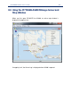
8.2 Built-in Functionality
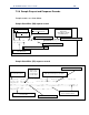
Similar to PC*MILER|Mapping, PC*MILER for the AS400 has built-in
zooming features, and a menu that can be invoked using the right mouse
button which provides much of its functionality.
To zoom into an area, drag a rectangle (hold down the left mouse and
drag) or double-click on a point (this will zoom in and place the point at the
center of the map).
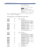
The following commands can be selected from the right mouse menu:
Zoom In: Zoom in by a factor of two; can be repeated for closer views;
increases detail.
Zoom out: Zoom out by a factor of two; can be repeated; decreases
detail.
Pan: Pan map north, south, east or west.
Frame: Frame the specified geographic region.
Drag Map: Pan map by clicking and dragging.
Features: Controls drawing of various feature sets.
Redraw: Refresh the current display in the Map Window.
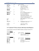
Detail: Without zooming, add to, reduce, or return to the default
number of roads, road names and place names drawn on the
map. Choose More, Less, or Default from the sub-menu.
Labels: Choose one from the sub-menu:
Pick Cities: enable user to label and deselect locations and
road intersections with the mouse
Pick Roads: enable user to label and deselect roads with
the mouse
Pick Pins: enable user to click on a pin to display a window
listing information about the icon
Clear: delete all labels that have been added manually.
Legends: Show/Hide the Road Legend, and/or Scale of Miles.
NOTE: The Hazmat Legend is controlled from the Features Menu