
User`s guide

42 PC*MILER User’s Guide
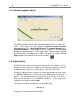
3.8 Latitude\Longitude Points
PC*MILER enables you to enter latitude\longitude points as stops on a
route. These points can be entered in degrees minutes seconds
direction format (e.g. 0401750N,0742131W) or decimal degrees (e.g.
40.123N,100.333W). Lat\long points will be labeled in the RouteMap
window just like other stops. In Pick Stops mode, lat\longs can be entered
by clicking on the map wherever a node is not present. (Click the Pick
Stops button on the tool bar to turn on this mode.)
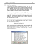
3.9 Highway Exits
PC*MILER now includes all Interstate-to-Interstate exit numbers. It also
includes all Interstate exits leading to non-Interstate highways, with the
exception of exits that have an A\B suffix (e.g. Exit 36A, Exit 14C).
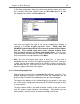
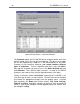
To enter a highway exit as a stop in the route entry window, you can enter
“^” (Shift-6) followed by a comma and state abbreviation to bring up a
pick list. For example, entering “^, nj” brings up a pick list of all exits in
New Jersey that are in the PC*MILER database. Then make your
selection in the pick list and click OK.
You may also enter an exit directly. For example, type
^i10 x17, fl
to enter Exit 17 off Interstate 10 in Florida.