
User's Manual


8
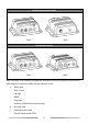
WideLink B600/B600W
Front Back
WideLink B600S
Front Back
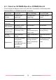
B600 exchanges the following navigational data with other AIS equipped vessels within
VHF range to increase the safety of your journey at sea:
Static data:
Ship´s name
Call sign
MMSI
Ship type
Location of GPS antenna on the ship
Dynamic data:
Position of the vessel
Course over ground (COG)