User Manual Alpine Navigation System Navigation software for the Alpine Navigation System English March 2015, ver. 1.
Table of contents 1 Warnings and safety information ............................................................................................ 5 2 Getting started ........................................................................................................................... 6 2.1 Initial set-up........................................................................................................................................ 6 2.2 Screen controls ............................................
.1.4 Selecting a Saved Location ....................................................................................................................... 38 3.1.5 Selecting a History item ............................................................................................................................ 39 3.1.6 Entering coordinates ................................................................................................................................. 40 3.1.
.1.9.4 Hints upon detour ............................................................................................................................................... 65 4.2 Information menu ............................................................................................................................. 66 4.2.1 Where Am I .............................................................................................................................................. 67 4.2.2 Trip Monitor ......
1 Warnings and safety information The navigation system helps you find your way to your destination with the built-in GPS receiver. Alpine Navigation System does not transmit your GPS position; others cannot track you. It is important to look at the display only when it is safe to do so. If you are the driver of the vehicle, we recommend that you plan and review your route before you start your journey. Plan the route before your departure and stop if you need to change the route.
2 Getting started Alpine Navigation System is optimized for in-car use. You can use it easily by tapping the screen buttons and the map with your fingertips. Easy map updates Update your maps regularly as road networks are continuously evolving all over the world. About 15% of the roads are changed each year, new ones are built, directions are altered, new speed limits are set, and many other changes are made. It is easy to keep the navigation system up-to-date. Go to alpine.naviextras.
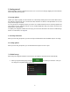
2. Read the end-user license agreement, and tap use. 3. The Configuration Wizard starts. Tap 4. Select the language and speaker used for voice guidance messages. Later you can change it in to continue. Regional settings (page 73). Tap 5. to continue. If needed, modify the time format and unit settings. Later you can change them in Regional settings (page 78). Tap 6. if you agree with the terms of to continue. If needed, modify the default route planning options.
7. The initial set-up is now complete, tap 8. A warning appears to draw your attention to the hazards of operating, entering data into or obtaining data from the Alpine Navigation System during driving or transportsation. After reading it carefully, tap Note! . to enter the navigation view. This warning pops up every time you start Alpine Navigation System. 2.
Alpine Navigation System saves your selections and applies the new settings without confirmation as soon as you use the controls. 2.2.2 Using the cursor You can select a map location by tapping the map during navigation. When a map location is selected, the cursor ( ) appears at the selected point on the map. The location of the cursor can be used as the destination of the route or a new Alert Point. You can also search for Places around it or add this location to your saved locations.
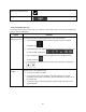
Finalizing the keyboard entry Tap . Hiding the keyboard Tap . 2.2.4 Using touch gestures You usually need to tap the screen only once. However, some useful features can be accessed with other gestures. See the table below. Action Function Tapping and Tap and keep pressing the following buttons to reach extra functions: holding the screen Tap and hold the following button on list and menu screens to show the Navigation view: .
2.2.5 Manipulating the map If you tap the map anywhere during navigation, the map stops following the current position (the blue arrow is not locked in a fix position on the screen anymore) and control buttons appear to help you modify the map view.
Changing 2D, 3D, or 2D North up views , , Switch between the 3D perspective, 2D Heading up, and 2D North up map view modes. In Heading up mode the map is rotated so its top always points in the current driving direction. This is the default orientation in 3D map view mode. In North up mode, the map faces North. Checking the compass The direction of the compass shows North.
2.3 Navigation view The navigation view is the main screen of Alpine Navigation System that shows the planned route on a map. Alpine Navigation System works with digital maps which are not simply the computerized versions of traditional paper maps. Similarly to paper road maps, the 2D mode of digital maps shows you streets and roads. Elevation is also illustrated in color.
Number Name Description 1 Current position marker The current position is displayed as a blue arrow by default. When there is no GPS position, the current position marker is transparent and it shows your last known position. See page 16. 2 GPS position The dot near the arrow shows the GPS position as perceived by the GPS receiver. See page 16. 3 Planned route 4 Data fields The planned route is displayed as an orange line.
13 Warning road sign It shows warning for the current road (for example, dangers, sharp curves). See page 75. 14 Signpost It shows the available destinations and the road numbers. See page 18. 15 Freeway services By tapping it, you can check the details of the next few service stations (gas stations, restaurants) when traveling on a freeway. See page 20. 16 Parking around destination It appears near the destination.
2.3.2 GPS position markers When your GPS position is available, Alpine Navigation System marks your current position. By default, this marker is a blue arrow. The dot near the arrow shows the GPS position as perceived by the GPS receiver. When on-road navigation is selected, the current position marker may not show your exact GPS position and heading. If roads are near, it is aligned to the nearest road to eliminate GPS position errors, and the direction of the icon is aligned to the direction of the road.
2.3.4 Turn preview and next street When navigating a route, the top section of the Navigation view shows information about the next route event (maneuver) and the next street or the next town. There is a field in the top left corner displaying the next maneuver. Both the type of the maneuver (turn, traffic circle, exiting freeway, and so on) and its distance from the current position are displayed. A smaller icon shows the type of the second next maneuver if it is near the first one.
Enter the freeway. Exit the freeway. Board the ferry. Leave the ferry. Approaching a waypoint on the right. Approaching the destination. 2.3.6 Lane information and signposts When navigating on multi-lane roads, it is important to take the appropriate lane in order to follow the planned route. If lane information is available in the map data, Alpine Navigation System displays the lanes and their directions using small arrows at the bottom of the map.
2.3.7 Junction view If you are approaching a freeway exit or a complex intersection and the needed information exists, the map is replaced with a 3D view of the junction. The lanes you need to take are displayed with arrows. At the top of the screen, road signs show you additional information. If you want to hide the currently displayed junction and return to the Navigation view, tap the picture. Junction view can be turned off in . See page 76. 2.3.
2.3.9 Freeway services When you are driving on a freeway, the button appears at the top right corner of the Navigation view. Tap it to open a panel with the details of the next few service stations (gas stations, restaurants). Tap any of them to display the exit area on the map. You can now easily add this service station as a waypoint to your route if necessary. If you want to display other types of Places at the next few service stations, you can change the icons in . See page 76. 2.3.
2.3.11 Traffic events Road segments affected by traffic events are displayed in a different color on the map. The following icons may appear at the top right corner of the screen: Button Description It is displayed when traffic events are not received. It is displayed when traffic events are received but they do not affect the planned route. It shows the type of the next traffic event with the expected delay.
You can see the following menu options when you are navigating without a planned route: Button Function Select your destination by entering an address or its coordinate, or by selecting a Place, a Saved Location, or a Saved Route. You can also look up your recent destinations from the History. When Internet connection is available, the Online Search option can be a further help to find your destination. Build your route from one or more route points.
The More button appears on the screen to display additional features. Tap it to open the list of additional features on certain screens. Tap the Back button to return to the previous screen. You can also press and hold this button to quickly return to the Navigation view from any other screen.
3 Using the navigation By default, Alpine Navigation System calculates routes using the road network of the maps provided with the product. You can select the destination and start navigating to it right away (normal navigation) if you need a route for immediate navigation. You can also plan a route independently of your current GPS position even without GPS reception. To achieve this, you need to set a new starting point in the Multipoint Route menu.
2. Tap . You can see the input field at the top of the screen. Right next to it you can see the search area, the town around which the search is carried out. The default search area is the area where you are located. For a local search, skip the next step. 3. (optional) To search in a different area, tap the input field with the search area, and start entering the name of the new search area on the keyboard. You only need to enter a few letters to get a result.
Tap to see the list of recent destinations with a matching name or address. Tap to see the list of your saved locations with a matching name. Tap to see the list of matching addresses. Tap to see the list of matching Place category names. Scroll the list and select one of the categories. You get the list of Places in that category ordered by their distance from your current position. Tap location.
3.1.2 Selecting an address If you know at least a part of the address, this is the quickest way to select your destination. Using the same screen, you can find an address by entering the following information: The exact address, including the house number, see page 27 The center of a town, see page 29 The midpoint of a street, see page 29 An intersection, see page 30 Any of the above, starting the search with the ZIP code, see page 30. 3.1.2.
b. 2. 3. To open the list, tap , and select the town or ZIP code. Enter the street name and the house number or crossing street by performing the following steps: a. Start entering the street name on the keyboard. The names that match the string appear in a list. b. Tap c. Enter the house number or crossing street on the keyboard. (To enter letters, tap d. Tap the selected address to finish the address search. to open the list of results. Select the street from the list. .
3.1.2.2 Selecting a town center The town center is not the geometric center of the town but an arbitrary point the map creators have chosen. In towns and villages, it is usually the most important intersection and in larger towns, it is one of the important intersections. 1. Press the navigation hardkey button to access the Navigation menu. 2. Go to 3. Select a new town or ZIP code by performing the following steps: and modify the country as described earlier (page 27), if necessary. a.
5. Instead of entering the house number, tap selected as the destination. . The midpoint of the street is 3.1.2.4 Selecting an intersection in a town To navigate to an intersection, perform the following steps: 1. Press the navigation hardkey button to access the Navigation menu. 2. Go to 3. Start entering the street name on the keyboard. The names that match the string appear in a list. 4. Tap 5.
2. Tap . 3. Tap 4. Tap 5. Continue the search as described previously (page 27). to open the numeric keypad and start entering the ZIP code. to open the list of results. Select the ZIP code from the list. 3.1.3 Selecting a Place of Interest You can search for Places of Interest (Places) in the menu.
3.1.3.1 Using Quick search categories The Quick search feature helps you quickly find the most frequently selected types of Places. Perform the following steps: 1. Press the navigation hardkey button to access the Navigation menu. 2. Tap . The following Quick search categories appear: : If a planned route exists, gas stations are searched along the route. : If a planned route exists, accommodation is searched around the destination.
. To filter the list of results by providers, tap on the right side of the screen. and then the provider logo 5. (optional) If needed, tap to further filter the list of results. 6. Browse the list and tap one of the list items. 7. The route is calculated and the map appears showing the entire route, where you can check route information and route alternatives. Tap to modify the route parameters, or tap to start your journey. 3.1.3.
Tap to search for a place within a selected town. (The result list is ordered by the distance from the center of the selected town.) 4. (optional) If you have selected , select the town to search in. 5. Select one of the main Place categories (for example, Accommodation), then browse the subcategories (for example, Hotel or Motel) to find your destination. 6. You can turn the Category View off at any level to list all Places around the selected location or along the route. 7.
Tap to reorder the list. To filter the list of results by providers, tap screen. and then the provider logo on the right side of the 8. Browse the list and tap one of the list items. A full screen map appears with the selected point in the middle. 9. The process continues the same way as in case of any other search for Places. See page 32. 3.1.3.
4. (optional) If you have selected , select the town to search in. You can search for the name of a Place in all categories by performing the following steps: 1. Tap the categories. . Using the keyboard, start entering the name of the Place or browse in 2. After entering a few letters, tap to open the list of Places or Place categories with names containing the entered character sequence. 3. Browse the list, if necessary, and tap the desired list item.
3.1.3.4 Finding help nearby To quickly search for nearby assistance, perform the following steps: 1. Press the navigation hardkey button to access the Navigation menu. 2. Tap and . Places in the following pre-set search categories can be searched for around the current position (or around the last known position if the current position is not available): : Car repair and roadside assistance services : Medical and emergency services : Police stations : Gas stations 3.
3.1.4 Selecting a Saved Location To select a location that you have already saved (page 53), perform the following steps: 1. Press the navigation hardkey button to access the Navigation menu. 2. Tap 3. The list of Saved Locations is displayed. It contains two pre-set categories: Home and Work. 4. Tap the location that you want to set as your destination. If necessary, browse the list to see more results. 5. (optional) If needed, tap the Saved Locations or delete any of them. 6.
3.1.5 Selecting a History item The destinations that you have used earlier appear in the History list. Smart History offers these locations from your previous destinations, using parameters like the current time of day, the day of week, and the current location. The more you use the navigation software, the better it can guess your desired destination. To select a History item, perform the following steps: 1. Press the navigation hardkey button to access the Navigation menu. 2.
3.1.6 Entering coordinates To select a destination by entering its coordinates, perform the following steps: 1. Press the navigation hardkey button to access the Navigation menu. 2. Tap 3. You can enter the latitude and longitude values in any of the following formats: decimal degrees, . degrees and decimal minutes, or degrees, minutes and decimal seconds. Tap . (optional) If necessary, tap coordinate in UTM format. then and enter the Tip! 4.
3.1.7 Selecting a location on the map To select a map location, perform the following steps: 1. Locate your destination on the map. Move and scale the map as necessary. 2. Tap the location that you want to select as your destination. The cursor ( 3. (optional) If needed, tap this location. Tip! ) appears there. to list the Places near the selected point or to save If you already have a planned route, tap add the selected location to your route. and to 4.
3.1.8 Planning a Multipoint Route To build your route destination-by-destination, perform the following steps: 1. Press the navigation hardkey button to access the Navigation menu. 2. Tap 3. There is only one line in the list of route points, the starting point of the route, which is normally the current GPS position. 4. Tap 5. The New Route to... screen appears, where you can select the destination of the route the same way as described in the previous sections. 6.
8. (optional) Tap also delete all the destinations. to optimize the whole route or the order of waypoints. You can 9. When you have added all the route points, tap automatically calculated. and the planned route is 3.2 Checking Route Information and Alternatives To get a map overview of the planned route and check different parameters of the planned route, perform the following steps: 1. Press the navigation hardkey button to access the Navigation menu. 2. In the Navigation menu, tap 3.
Tap to list route alternatives and select the most suitable route for you. Tap on the Route Summary screen to carry out additional actions, for example edit your route preferences or display the itinerary. 3.3 Checking Traffic Events Offline statistical traffic information (historical speed information or traffic patterns) can be taken into account in the route calculation based on the time of day and the day of week if suitable data can be found on the device.
2. If there is at least one significant event on the planned route, a description is displayed about the next event. Tap 3. to see the list of all events. Tap any of the list items to see its details and to display the affected road segment in its full length on the map. To display real-time traffic information on the map, perform the following steps: 1. On the Navigation view, tap the traffic icon (for example, screen and tap 2. ) to open the Traffic summary .
Tap to display historical traffic information. A 2D map is displayed with road segments colored by the likely density of the traffic in the given period. The information relevant for the current period is shown when you open the screen. If necessary, you can browse the map for a better view of certain road segments. Modify the day of week and the time of day to see the desired period. 3.4 Editing the route When navigation has already started, there are several ways to modify the planned route.
3.4.1 Setting a new starting point For normal navigation, all routes are calculated from the current position. You can pause navigation to check future routes, simulate them or see their length in time and distance. Then you can set the starting point of the route to a location other than the current GPS position. 1. Press the navigation hardkey button to access the Navigation menu. 2. In the Navigation menu, tap 3.
6. Tap to continue. The map returns with a transparent position marker (showing that there is no GPS reception). If a planned route already exists, it is now recalculated starting from the selected location. 7. To return to normal navigation, tap . 3.4.2 Adding an additional destination If you already have a planned route and you select a new destination as described in the above sections, the route to the previous destination is deleted and a new route is calculated.
3.4.3 Modifying the list of destinations To edit your route, perform the following steps: 1. Press the navigation hardkey button to access the Navigation menu. 2. In the Navigation menu, tap . You have the following options on this screen: Tap route. Tap the name of the intermediate destination to move it up or down in the list, to save the location, or to delete it from the list.
3. Type in a name and tap . 4. The route is saved and it is available in in the Navigation menu. By selecting a previously saved route, Alpine Navigation System recalculates the route using the saved destination and/or the waypoints. 3.4.
3.4.6 Selecting a route alternative when planning the route To select from different route alternatives or change the route planning method after you have selected a new destination, perform the following steps: 1. Select a destination as explained earlier, and go to the route confirmation screen. 2. Tap 3. You can see the basic details of route alternatives. Tap any of them to see it on the map. 4. To view more suggestions, tap with different route planning methods. 5.
3.4.7 Selecting a route alternative for an existing route To recalculate the planned route with a different route planning method and to compare different route alternatives, perform the following steps: 1. Press the navigation hardkey button to access the Navigation menu. 2. You can access the list of route alternatives from the Navigation menu in one of the following ways: 3. Tap and Tap and . . You can see the basic details of a few route alternatives.
3.5 Saving a location To add any location to the saved locations (the list of frequently used destinations), perform the following steps: 1. Select a destination as described before. It can be an address, a Place, any location on the map, a previously used destination from History, and so on. 2. When the map appears with the route, tap 3. Tap 4. (optional) Using the keyboard, you can change the name offered for the Saved Location. 5. Tap . . to save the location.
3.5.1 Editing a Saved Location To edit a location that you have already added as a Saved Location, perform the following steps: 1. Press the navigation hardkey button, and tap 2. The list of Saved Locations is displayed. 3. Tap 4. Tap the location you want to edit, tap . and the keyboard, then tap . and enter the name of the location on . In Saved Locations, Home and Work cannot be renamed. To change your home or work Note! 5. location, tap change. Tap or , and confirm the address .
The warning for road safety cameras is disabled when you are in a country where road safety camera warning is prohibited. However, you must make sure that using this feature is Note! legal in the country where you intend to use it. 1. Return to the Navigation view, and select the Alert Point. The red cursor ( ) appears there. 2. Tap 3. Scroll down the list and tap 4.
3.7 Running a Simulation To run a simulated navigation that demonstrates the planned route, perform the following steps: 1. Press the navigation hardkey button to access the Navigation menu. 2. In the Navigation menu, tap 3. Tap 4. Tap . The simulation starts from the starting point of the route and leads you through the whole planned route using a realistic speed. . .
5. Tap : Tap to increase the speed of the simulation to 4, 8 or 16 times faster. Tap again to return to normal speed. to stop the simulation. 3.8 Off-road navigation When first started, Alpine Navigation System calculates routes using the road network of the maps provided with the product. If you want to disregard roads during navigation, you can switch to off-road mode, for example when driving in a desert. 3.8.
3.8.3 Navigating in off-road mode The real difference between on-road and off-road modes is the navigation itself. When you are on the Navigation view with an off-road route: Your position and heading is not aligned to the nearest road. There is no turn-by-turn navigation, just a recommended direction. You can see an orange line drawn between your current position and the next destination to reach.
Do not switch off your navigation system during the following process. Caution! Do not remove the USB storage device until the preparation process is completed. 3. 4. a. Start the navigation system while your vehicle is parked. b. Insert the empty USB storage device into the USB port of your navigation system. c. Press the navigation hardkey button, and in the Navigation Menu, tap . d. Tap Yes on the confirmation screen.
4 Reference guide The following sections describe the different concepts and menu screens of Alpine Navigation System. 4.1 Concepts The following sections describe and explain navigation-related concepts. 4.1.1 2D/3D GPS reception The GPS receiver uses satellite signals to calculate its (your) position and needs at least four signals to give a three-dimensional position, including elevation.
Audio warning: beeps are played (if the voice guidance language that you selected is a natural voice) or the type of the alert can be announced (TTS voice) while you are approaching one of these points, and an extra alert warns you if you exceed the given speed limit while approaching. Visual warning: the type of the Alert Point, its distance and the related speed limit appear on the Navigation view while you are approaching one of these locations.
While driving without a planned route: Smart Zoom zooms in if you drive slowly and zooms out when you drive at a high speed. 4.1.6 Speed limit warning Maps may contain information about the speed limits of the road segments. Alpine Navigation System is able to warn you if you exceed the current limit. This information may not be available for your region, or may not be fully correct for all roads on the map. The maximum speed set in the vehicle profile (page 70) is also used for this warning.
TMC is a specific application of the FM Radio Data System (RDS) used for broadcasting real-time traffic and weather information. If public Traffic data is broadcast at your location, Alpine Navigation System automatically searches the FM radio stations for TMC data, and the decoded information is immediately used in route planning. Note! TMC is not a global service. It may not be available in your country or region. Ask your local dealer for coverage details.
You can ignore this message and keep the original route by tapping check the suggested route by tapping or you can . By tapping the plus/minus signs, you can increase or decrease the distance to avoid on the highway. You can accept the recommended detour by tapping . 4.1.9.2 Real-time alternative routes Alpine Navigation System may offer an alternative route on normal roads in case of a traffic jam. The possible alternative route window appears and shows the length and duration of the detour.
4.1.9.3 Parking around destination If you leave the planned route by exiting a freeway, Alpine Navigation System tries to guess the reason for making a detour. By tapping , you can open a top-down map with the recommended parking Places around the destination. By tapping the arrows on the sides, you can switch between the recommended parking facilities. By tapping destination.
4.2 Information menu The Information menu provides various additional functions. It can be found in the Navigation menu. You need an Internet connection via your cell phone to access online services, like parking and weather information. Button Description Shows information on the current position (latitude, longitude, nearest town, next crossing street, and so on) or the last known position if GPS reception is not available. See page 67. Offers assistance near your current position. See page 37.
4.2.1 Where Am I This screen contains information about the current position (or about the last known position if GPS reception is not available). You can access it the following two ways: By going to the Navigation menu and tapping By tapping the current street name if it is displayed below the current position marker on the map. and .
4.2.2 Trip Monitor Trip Monitor logs information about your route. You can record a new trip by tapping By tapping and stop it by tapping . on the Trip Monitor screen, you can select the following options: Button Function By selecting a recorded trip, you can delete, rename, or change the color of the recorded route. You can access the Trip Monitor Settings, where you can enable saving the trip logs automatically or you can save the trip logs manually. See page 81.
The Setup menu provides the following options: Button Function Select the type of vehicle you are driving, the road types used in route planning, and the route planning method. Adjust the different sound volumes. Enable and set up warnings for speed limit, Alert Points (such as speed cameras), and road signs. Fine-tune the appearance of the Navigation view or adjust how the software helps you navigate with different kinds of route-related information on the Navigation view.
4.3.1 Route preferences The following settings determine how routes are calculated: Button Function Set the type of vehicle you want to use to navigate the route. Based on this setting, some of the road types can be excluded from the route, or some of the restrictions may not be taken into account in route calculation. See page 70. Edit the parameters of the vehicle profile. See page 70. Optimize the route calculation for different situations and vehicle types by changing the planning method. See page 72.
Maneuver restrictions and one-way streets are taken into account when planning a route. Roads are used only if access for taxis is allowed. Private roads, resident-only roads and walkways are excluded from routes. Maneuver restrictions and one-way streets are taken into account when planning a route. Roads are used only if access for trucks is allowed. Private roads, resident-only roads and walkways are excluded from routes.
4.3.1.2 Route Planning Method types You can select from the following route planning method types: Button Description Gives a quick route if you can travel at or near the speed limit on all roads. Usually, the best selection for fast and normal cars. Results in a route with fewer turns and no difficult maneuvers. With this option, you can make Alpine Navigation System take, for example, the freeway instead of a series of smaller roads or streets. Gives a short route to minimize the travel distance.
Charge roads are pay roads where you can purchase a pass or vignette to use the road for a longer period of time. They can be enabled or disabled separately from toll roads. Per-use toll roads are pay roads where there is a per-use charge in the routes by default. If you disable toll roads, Alpine Navigation System plans the best toll-free route. Alpine Navigation System includes ferries in a planned route by default.
You have the following options for each sound type: Button Volume slider Function Adjust the volume of the related sound. Mute the related sound. The slider becomes inactive. Tap again to re-enable it. Button Function Disable verbal instructions. This function is enabled by default. Choose from the following options: Announce the street names in the native language area of the selected voice guidance language. Announce the road numbers only. Announce the maneuvers only.
Allow announcing system messages. 4.3.3 Warnings You can enable and modify the following settings: Button Description Alpine Navigation System is able to warn you if you exceed the current speed limit. This information may not be available in your region, or may not be fully correct for all roads on the map. The maximum speed set in the vehicle profile is also used for this warning. Alpine Navigation System alerts you if you exceed the pre-set value even if the legal speed limit is higher.
Tap it to receive a warning when approaching a road safety camera or other Alert Points like school zones or railroad crossings. You must make sure that using this feature is legal in the country where you intend to use it. You can set the warning type for the different Alert Point categories (alert types) individually.
You can modify the following settings: Button Function Adjust the basic zoom and tilt levels to your needs. Three levels are available. Switch between daytime and night color modes or let the software switch between the two modes automatically a few minutes before sunrise and a few minutes after sunset. Select the color scheme used in daytime mode. Daytime colors are bright and similar to paper road maps. Select the color scheme used in night mode.
Zoom out and show an overview of the surrounding area if the next maneuver is far and you are driving on a freeway. When you get close to the event, the normal map view returns. Whenever adequate information is available, lane information similar to the real ones on road signs above the road is displayed at the top of the map. Tap it to turn this feature on or off.
It shows the current voice guidance profile. Tap it to select a new profile from the list of available languages and speakers. Tap any of these to hear a sample voice prompt. Just tap when you have selected the new spoken language. Different voice profiles are capable of different levels of service: Natural Voice (street names not announced): These pre-recorded sounds can only tell you basic information about turns and distances.
4.3.7 Traffic You can modify the following settings: Button Function Enable or disable the Traffic reception that can receive real-time traffic information. The rest of the buttons below are all related to the Traffic function and are available only if the receiver is enabled. Tap it if you want to use online traffic information to avoid road blocks or unexpected traffic jams.
4.3.8 Trip Monitor Trip logs contain useful information about your recorded trips. You can enable and modify the following settings: Button Description Trip monitor can record statistical data of your trips. If you need these logs later, you can let the application save them automatically for you. Track logs, the sequence of the positions given by the GPS receiver, can be saved together with trip logs. They can later be displayed on the map.
5 End-user license agreement 0. Definitions The following terms shall have the meaning defined hereunder in this agreement when used with capital letters. The text of this agreement may also contain further defined terms. “Agreement” means this End User Licence Agreement (EULA) containing the terms and conditions of use of the Software, Databases and Services by You as the end user.
term is defined at 48 C.F.R (“FAR”) 2.101 and that all use of the Navigation Product is subject to this Agreement. 3 Applicable law and venue 3.1 This Agreement will be governed by the laws of the country where the Licensor has its statutory seat or in the absence of such incorporation where it has its central administration (“country of residence”) without regard to such country’s choice of law provisions. 3.2 The courts of the country of residence specified in Section 3.1.
5.2 Intellectual property rights of Licensor, the Software Owner or other rightholders extend to the whole Navigation Product and to its parts separately as well. 5.3 The owner(s) of the copyrights of the Database(s) is (are) the Licensor, or natural person(s) or corporate business entity(ies) (referred to as: “Database Owner”) who supply them.
store, to transfer or to distribute these data or contents or to disclose them in full or in part to the public in any format or to download them from the Navigation Product. 8. No warranty, limitation of liability 8.
Safety (e.g. speed) cameras are provided for informational purposes only and may not be used to encourage, facilitate or support the violation of any laws. Furthermore some countries prohibit the display or use of such features. Compliance with country specific laws and any usage or reliance on the information by user shall be at the User's own risk and sole responsibility. 8.7 Database and Services provided by third parties.
10.4 Licensor hereby informs the User, that if it accesses the Internet through mobile data service while abroad or otherwise roaming another mobile network the transmission of such data may result in special roaming charges. To avoid such charges it is the responsibility of the User to disable mobile data services while roaming or to turn off the data collection functions of the Navigation Product. 11. Auxiliary Terms for Services 11.1 For online Services the following auxiliary terms shall also apply.
11.7. Community Services. Some Connected Services may be based on data and information uploaded by participating individuals (Users or other persons) or a Database created and maintained by a group of such individuals. Such data may not come from a trusted source and may also be intentionally false or misleading, as Licensor or Software Owner does not have any means to control or verify the credibility or accuracy of such data or the individuals providing the data.
6 Copyright note The product and the information contained herein are subject to change without prior notification. This manual may not, in whole or in part, be reproduced or transmitted in any form either electronically or mechanically, including photocopying and recording, without the express written consent of Alpine Electronics, Inc. © 2015 – Alpine Electronics, Inc. All rights reserved. © 2015 – NNG Kft. All rights reserved. Map data: © 1987 - 2015 HERE. All rights reserved. See http://corporate.