
Extra Information


12
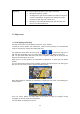
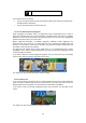
The data fields are different when you are navigating an active route and when you have no
specified destination (the orange line is not displayed).
Default data fields when cruising without a destination (tap any of the fields to change its
value):
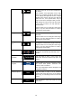
Field Description
Shows your current speed given by the GPS receiver.
Shows the speed limit of the current road if the map contains it.
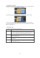
Default data fields when navigating a route (tap any of the fields to change its value):
Field Description
Shows the distance you need to travel on the route before reaching
your final destination.
Shows the time needed to reach the final destination of the route
based on information available for the remaining segments of the
route.
If your device is capable of receiving live traffic information, the
calculation takes into account traffic delays affecting your route if they
are received. However, this calculation is rarely accurate.
Historical traffic data can also be taken into account if data is
available.
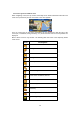
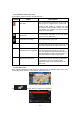
There are three map view modes. Tap the button below the data fields to change the view:
•
: 3D perspective view rotated in your direction of travel.
•
: 2D top-down view facing North.
•
: 2D top-down view rotated in your direction of travel.