
Owner's Manual


72
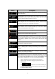
• Roads are used only if access for taxis is allowed.
• Private roads, resident-only roads and walkways are excluded from routes.
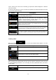
Route Planning Method types:
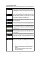
Button
Description
Gives a quick route if you can travel at or near the speed limit
on all
roads. Usually the best selection for fast and normal cars.
Gives a short route
to minimise the distance to travel. It can be
practical for slow vehicles. Searching for a short route regardless of
the speed, this route type is rarely practical for normal vehicles.
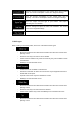
Gives a quick but fuel efficient route based on the fuel consumption
data given in Route settings (page 69). Travel cost and CO
2
emission
calculations
are estimations only. They cannot take elevations, curves
and traffic conditions into account.
Results in a route with fewer turns and no difficult manoeuv
res. With
this option, you can make your software to take, for example, the
motorway instead of a series of smaller roads or streets.
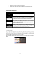
5.3.5 Map settings
You can fine-tune the appearance of the Map screen. Adjust the map view to your needs,
choose suitable colour themes from the list for both daytime and night use, change the blue
arrow to a 3D car model, show or hide 3D buildings, turn track logging on or off, and manage
you Place visibility sets (which Places to show on the map).
The map is always shown on the screen so that you can see the effect when you change a
setting.