
Developers guide


100
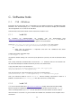
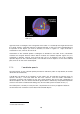
Figure E-2 Equatorial coordinates, sourced
from [ 4 ].
Right Ascension is analogous to the longitude of the earth. It is essentially the angle formed from
the vernal equinox, eastwards along the celestial equator, to the hour circle corresponding to
the position of the object you wish to describe, as shown in Figure E-2. Right ascension is
measured in hours, minutes and seconds
i
.
Declination on the celestial sphere is analogous to latitude on the earth. That is, declination
measures the angular distance either above or below the celestial equator (Figure E-2). It is
measured in degrees, minutes, and seconds from +90 to -90 degrees. Such that 0 degrees
specifies objects on the celestial equator, +90º indicates that an object is on the north celestial
pole, and -90º on the south celestial pole
E.1.3. Coordinate epochs
The introduction of the celestial sphere provided a reference point for equatorial (and other
astronomical coordinates).
Coordinates are based on the position of the earths axis and equator at specific times, or
epochs. January 1, 1950 and 2000
ii
are the most common. Since the earths orientation is
constantly changing with respect to the stars, these positions are tied to the coordinates of
observed objects. Thus, the B1950 coordinate grid location is defined by the published positions
of stars in the fourth Fundamental-Katalog, FK4, and the J2000 system is based on FK5 [ 7 ].
The J2000 system, currently in use by the APT, can provide an accuracy of approx 0.0005 arc
seconds based on a reference set of about 400 celestial objects.
i
From 0 to 24 hours.
ii
Julian date 2451545.0