
Developers guide


99
E. Astronomy primer
E.1. Celestial coordinate systems
Several Celestial Coordinate Systems are used by astronomers to record the positions of objects
in the sky. Some material in this section is an abridgement of the content in [ 4 ].
Both the Equatorial and Horizon coordinate systems are very similar to the well known Terrestrial
coordinate system which uses longitude and latitude to specify a position on the earth. In order
to understand how these coordinate systems work, the concept of the celestial sphere must be
introduced.
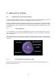
E.1.1. Celestial sphere
The celestial sphere is a very large imaginary sphere which surrounds the earth. Like the earth, is
has a north and south pole, and an equator. The Ecliptic is a circle on the plane of the earth’s
orbit. See Figure E-1.
A line constructed from the centre of the earth, through an observer on the surface will intersect
the celestial sphere at a point called the Zenith. I.e. pointing at the Zenith is always looking
straight up.
Figure E-1 Celestial sphere, sourced from [ 4 ].
E.1.2. The equatorial coordinate system
The Equatorial Coordinate System uses the hour lines and the celestial equator to specify the
position of objects in the sky.