
- APOLLO Stereo Amplifier 50, 55, 60, 65 User's Guide
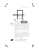


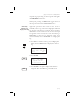

Table Of Contents
- Table of Contents
- Introduction 1-1
- Apollo GX Features 1-9
- Getting Started 2-1
- Navigation Basics 3-1
- About the Navigation Function 3-1
- About the Navigation Function Displays 3-1
- Nav Home Page 3-1
- Autonav 3-2
- Relative Bearing Indicator 3-3
- Nav Pages 3-3
- Estimated Time En Route ( Ete ) 3-4
- Bearing ( Brg ) 3-4
- Range ( Rge ) 3-4
- Course Deviation Indicator ( CDI ) and Distance Off Track 3-5
- TO/FROM Indicator 3-6
- Desired Track ( Dtk ) 3-6
- Leg (FROM-TO) Distance 3-6
- Track ( Trk ) Angle 3-7
- Track Angle Error ( Tae ) 3-7
- Ground Speed (GS) 3-7
- Minimum Safe Altitude (MSA) 3-8
- Minimum En Route Safe Altitude (MESA) 3-8
- Flight Time 3-9
- Time UTC 3-9
- Estimated Time of Arrival (ETA) 3-9
- Nearest Waypoint & Airspace Search 3-9
- Controlled Special Use Airspace 3-13
- Altitude Assist ( VNAV ) 3-14
- Parallel Track Offset 3-19
- GPS Position 3-21
- Countdown Timer 3-22
- Arc Assist 3-23
- Waypoint Distance Page 3-25
- Waypoint ETE Page 3-25
- From-To-Next Waypoint ETA Page 3-25
- From/To/Next Waypoint 3-26
- Using Direct-To 3-31
- Direct-To Examples 3-32
- Direct-To OBS 3-35
- Turn Anticipation 3-36
- GPSS 3-37
- Tuned Station 3-39
- Moving Map Functions 4-1
- Full Screen Map 4-1
- Controls 4-2
- Map and Nav Info 4-3
- Map Setup 4-4
- Search and Rescue 4-14
- Search and Rescue Map Description 4-14
- Grid Line Display 4-15
- US Grid Type 4-15
- Basic Grid Type 4-16
- Search and Rescue Map Setup Page 4-16
- Set the SAR Position (Basic Grid Type) 4-18
- Selecting A Pattern 4-20
- Parallel Line Search Pattern 4-21
- Creeping Line Search Pattern 4-23
- Expanding Square Search Pattern 4-26
- Mark A Position 4-28
- Create A User Waypoint By US Grid 4-29
- Fly Direct To A US Grid 4-30
- Create a User Waypoint By Basic Grid 4-30
- Fly Direct To A Basic Grid 4-32
- Setting Up A Search Pattern 4-32
- Waypoint Database 5-1
- Waypoint Information 5-1
- Available Waypoint Information 5-1
- Getting Information About A Waypoint 5-3
- Airport Info Pages 5-5
- Create User Waypoint by Lat/ Lon 5-9
- Create User Waypoint by Radial/Distance 5-10
- Update User Wpt with Present Pos 5-12
- Delete User Waypoint 5-12
- Modify User Waypoint 5-13
- Creating Waypoint Comments 5-14
- Deleting Waypoint Comments 5-15
- Update User Waypoint 5-16
- Datacard 5-16
- RNAV Waypoints 5-16
- Flight Plan Functions 6-1
- Flight Plan Pages 6-1
- Creating a Flight Plan 6-2
- Flight Plan Sequencing 6-5
- Flight Plan Leg Information 6-6
- Manual Leg Activation 6-9
- Flight Plan Editing 6-10
- Flight Plan Options 6-14
- Activate 6-14
- Rev Activate 6-15
- Reactivate 6-15
- Rename 6-15
- Copy Plan 6-16
- Estimated Ground Speed 6-16
- Clear Waypoints 6-17
- Reverse Flight Plan 6-17
- Estimated Fuel Flow 6-17
- Delete Plan 6-18
- Hold 6-18
- Holding Patterns (GX50/60) 6-19
- Continue 6-21
- Load Approach (GX50/60 Only) 6-22
- Change Approach (GX50/60 Only) 6-22
- Unload Approach (GX50/60 Only) 6-22
- Enable Approach (GX50/60 Only) 6-23
- Disable Approach (GX50/60 Only) 6-23
- Destination Waypoint Information 6-23
- Flight Plan Comments 6-23
- Saving an Active Flight Plan 6-24
- System Functions 7-1
- Message Function 8-1
- Approach Basics (GX50/60) 9-1
- Introduction 9-1
- Approach Procedure 9-5
- En Route Operations 9-5
- Approach Transition Operation (Enabling Approach) 9-8
- Approach Active Operation 9-11
- Missed Approaches 9-13
- Canceling An Approach 9-15
- Repeating an Approach 9-16
- Selecting a Different Approach 9-17
- Direct-To 9-18
- Manually Selecting a Flight plan Leg 9-19
- Flight Plan Waypoint Sequencing 9-20
- Procedure Turns 9-21
- Procedure Turn at FAF 9-22
- Holding Patterns 9-24
- DME Arcs (Arc Assist) 9-26
- Vector to Final 9-27
- Navigating to a DME 9-28
- RAIM 9-29
- RAIM Nav Page (GX50/60 Only) 9-33
- Emergency (Alternate) Approach 9-35
- Approach Examples 9-37
- Approach Example 1 - Straight In 9-39
- Approach Example 2 - Holding at IFAF 9-44
- Approach Example 3 - Missed Approach 9-51
- Approach Example 4 - VOR Reference 9-56
- Manual Flight Plan Leg Selection Example 9-61
- Approach Example 5 - DME Arc 9-63
- Approach Example 6 - Procedure Turn 1 9-66
- Approach Example 7 - Procedure Turn 2 9-68
- Using the LOC-DME Waypoint 9-69
- Approach Notes 9-77
- Comm Radio Operation 10-1
- Start Up Displays 11-1
- Flight Simulator 12-1
- Troubleshooting 13-1
- GPS Navigation 14-1
- Glossary 15-1
- Index
- A
- Abbreviations 10-4
- Access database 5-3
- Activate flight plan 6-14
- Air pressure 7-20
- Air speed 7-20 - 7-21
- Air temperature 7-20 - 7-21
- Airport elevation 5-6
- Airport frequency 5-6
- Airport Info 5-1
- Airspace
- Alternate approach 9-35
- Altimeter 7-20
- Altimeter Setting 3-14
- Altitude 7-21, 14-2
- Altitude assist 9-26
- Altitude Assist 3-14
- Altitude encoder 8-8
- Approach 8-6
- 30nm from dest. 9-9
- Active 9-2, 9-11
- Basics 9-1 - 9-36
- Cancel 9-15
- Change 6-22
- Disable 6-23
- Emergency 9-35
- Enable 6-23, 9-8
- Enroute 9-1, 9-5
- Examples 9-37 - 9-76
- Final Approach Fix 9-10
- Initial Approach Fix 9-10
- Load 6-22
- Load approach 9-7
- Load destination 9-6
- Missed Approach Point 9-12
- Notes 9-77 - 9-90
- Phase II GPS 9-89
- Phase III 9-90
- Procedure 9-5
- Repeat 9-16
- Select different 9-17
- Transition 9-2
- Unload 6-22
- Waypoint info 5-8
- Waypoints 9-77
- Wpt arrival 9-2
- Approach operation 9-30
- APT smart key 1-6
- Arc assist 3-23
- Arc Assist 3-24
- Arrival alert 8-9
- Arriving at TO wpt 8-9
- ATC ring 4-12
- Auto descent 3-17
- Auto store frequency 10-6
- Auto-Descent 3-18
- Autonav 3-2, 7-1, 7-4
- Autopilot 3-37
- B
- C
- Cancel approach 9-15
- CDI 3-5, 3-32, 6-20
- CDI reverse sensing 9-22
- Change approach 6-22
- Cleaning 13-2
- Clear exclusion list 9-35
- Clear flight plan wpts 6-17
- Close 4-11, 8-3
- Close altitude 8-4
- Com
- Comm radio
- Comm Radio 10-1 - 10-12
- Comments
- Continue flight plan 6-21
- Controls 1-3
- Conventions 1-iv
- Copy flight plan 6-16
- Countdown timer 3-22, 8-14
- Courrse intercept 8-10
- Create User waypoint 4-29
- Creeping Line Pattern 4-23
- Cross track distance 3-6
- Crossing FAF 9-12
- Current time 2-1
- Customizing Nav pages 7-2
- D
- Database 5-1 - 5-16
- Database expired 8-13
- Database invalid 8-13
- Database message 11-5
- Database test 11-4
- Datacard 5-16
- Date and Time 7-11
- Delete flight plan 6-18
- Density altitude 7-21
- Descent rate 3-17
- Description
- Desired heading 7-21
- Desired track 3-6
- Diamond 3-1
- Direct-To 2-7, 3-31 - 3-32, 6-9, 7-8, 9-18
- Disable approach 6-23
- Display 1-2
- Display brightness 7-14
- Distance off track 3-5
- Distance to waypoint 3-25
- DME Arc 3-24, 8-11 - 8-12, 9-26, 9-63, 9-87, 12-1
- DTK Up 4-5
- Duplicate names 2-4, 5-4
- E
- Edit owner information 7-16
- EEPROM 11-4
- Elevation 5-6
- E-Mail 1-ii
- Emergency approach 9-35
- Emergency channel 10-8
- Emergency search 3-9
- Empty TO waypoint 8-4
- En route operation 9-30
- Enable approach 6-23, 9-8
- Encoder altitude 3-15
- Encoding altimeter 7-20
- Ending Altitude 3-18
- Enroute 9-1, 9-5
- Error messages 8-3
- Estimate ground speed 6-16
- Estimated fuel flow 6-17
- Estimated time enroute 3-4, 6-7 - 6-8
- Estimated time of arrival 3-9, 6-7
- ETA to waypoint 3-25
- ETE to waypoint 3-25
- Examples
- Exclude satellite 9-34
- Expanding Square Pattern 4-26
- External Annunciators 1-3, 11-10
- F
- Factory 13-1
- FAF 9-10, 9-12
- FCC Notice 1-iii
- Features 1-9
- Find waypoint 2-1, 2-6
- Flight plan 6-1 - 6-26
- Activate 6-14
- Activating 2-9
- Active 6-2
- Clear waypoints 6-17
- Comments 6-23
- Continue 6-21
- Copy plan 6-16
- Creating 2-8, 6-2
- Delete plan 6-18
- Deleting legs 6-12
- Editing 6-10 - 6-11
- Estimate ground speed 6-16
- Estimated fuel flow 6-17
- Hold 6-18
- Inserting legs 6-11
- Leg info 6-6
- Manual leg 6-9
- Manual leg select 9-19
- Memory failure 8-12, 11-3
- New waypoint 3-33
- Options 6-14
- Pages 6-1
- Reactivate 6-15
- Rename 6-15
- Rev activate 6-15
- Reverse flight plan 6-17
- Saving Active plan 6-24
- Sequencing 6-5
- Waypoint sequencing 9-20
- Flight simulator 12-1 - 12-4
- Flight time 3-9, 7-8
- Flip/Flop key 1-8
- Frequency abbreviations 10-4
- From 6-19
- FROM waypoint 3-6
- From/To/Next 3-26, 3-29
- From-To distance 3-6
- Fuel 5-7 - 6-8
- Fuel endurance 7-22
- Fuel flow 7-20
- Fuel info 7-22
- Fuel Measure 7-13, 7-24
- Fuel range 7-22
- Fuel sensor 7-20
- Fuel used 7-22
- Fuel warning 7-23
- Fuel/Air Data sensor 7-20
- G
- H
- I
- K
- L
- M
- Magnetic heading 7-20 - 7-21
- Magnetic variation 7-7, 8-13
- Magnetic wind direction 7-22
- Manual leg activation 6-9
- Manual prediction 9-33
- Manuals 1-ii
- Map 5-7
- Map reference 4-6
- Map setup 1-7, 4-4
- Map Setup
- Map waypoint keys 1-6
- Mark position 4-28
- May clear 7-9
- May Clear 2-7
- Measurement units 7-6
- Memory failure 8-13, 11-1
- Memory loss or failure 8-12
- Memory test 11-2, 11-4
- Message 8-1 - 8-14
- Microphone 10-9
- Minimum enroute safe altitude 3-8
- Minimum safe altitude 3-8
- Misc sensors 7-20
- Missed approach 9-13
- Missed approach point 9-12
- Monitor frequency 10-3
- Moving map 2-10
- Moving Map 2-10, 4-1 - 4-32
- Multiple facilities 5-4
- N
- Nav page choices 7-5
- Nav superflag tests 11-9
- Nav Valid flag tests 11-9
- Navigation 3-1, 7-1
- NDB Info 5-2
- NDB smart key 1-6
- Nearest waypoint 2-6, 3-12 - 4-13, 5-9, 9-36, 10-6
- Nearest waypoint search 3-9, 5-1
- Never clear 7-9
- Noise level 10-10
- Non-volatile RAM test 11-3
- North Up 4-5
- NRST 1-2, 1-4, 2-6, 3-9 - 3-10, 3-12, 4-6, 4-13, 9-36, 13-3
- NVRAM 11-4
- O
- P
- R
- RAIM 8-5, 9-29, 9-33
- RAIM alarm 9-32
- Range 3-4
- Rate of climb 7-21
- Reactivate 6-15
- Recall frequency 10-4
- REF key 1-7
- Reference position 11-7
- Reference Waypoint 3-10, 5-10, 11-6
- Relative Bearing Indicator 3-3
- Remove unit from aircraft 12-2
- Rename flight plan 6-15
- Repeat approach 9-16
- Replace unit in aircraft 12-2
- Reserve fuel 7-23
- Rev Activate 6-15
- Reverse flight plan 6-17
- RF signal strength 10-10
- Right engine fuel 7-23
- RNAV 5-16, 9-1
- Route line 4-4
- Route line key 4-4
- RTE key 1-7, 4-4
- Runway info 5-7
- Runway length 3-12, 5-11
- Runway limits 3-12
- Runway surface 3-13
- S
- Save active flight plan 6-24
- Scan 4-3
- Scan key 1-7
- Search and Rescue 4-14
- Search around ref wpt 3-10
- Sectional Chart Grid 4-19
- Seed Position 11-5
- Select a waypoint 2-1, 2-3
- Select different approach 9-17
- Setting measurement units 7-6
- Setting up a search pattern 4-32
- Sidetone level 10-12
- Skip 1-6, 11-1
- Small knob 1-3
- Software memory test 11-2
- Software version 7-12
- SOON 8-3
- Sort waypoints 2-2
- Special use airspace 3-13
- Specifications 1-9 - 1-12
- Speed 7-22
- Squelch knob 1-3
- Standby 3-20
- Start up displays 11-1 - 11-12
- Startup bypass 11-1
- Storing a waypoint 2-5
- Stuck microphone 10-9
- Sunset/Sunrise time 5-8
- Symbol
- System 7-1 - 7-24
- T
- Technical assistance 13-1
- Terminal operation 9-30
- Tips 6-26
- To 6-19
- TO waypoint 2-4, 3-6, 4-1, 8-9
- TO-FROM flag tests 11-8
- Total fuel 7-23
- Track angle 3-7
- Track angle error 3-7
- Track History 4-8
- Track Up 4-5
- Transition 9-2
- Transmit Mic 10-11
- Troubleshooting 13-1 - 13-4
- True air speed 7-21
- True air temperature 7-21
- True north 7-7
- True wind direction 7-22
- TSO C129 overlay 9-77
- Turn anticipation 3-36
- Turn rate 7-21
- U
- V
- W
- Waypoint
- Airport info 5-1
- Approach 9-77
- Arrival 8-9, 9-2
- Auto OBS crossing 8-12
- Comment 5-8
- Comments 5-14 - 5-15
- Create 5-9 - 5-10
- Database 5-1 - 5-16
- Destination 6-23
- FROM 3-26
- From/To/Next 3-26
- Information 2-4, 5-1, 5-3
- Intersection info 5-2
- Last used 3-11
- LOC-DME 9-69
- Map 5-7
- Map identifier 4-2
- Naming conventions 9-87
- NDB info 5-2
- Next 3-29
- Scan 4-3
- Selection 2-1
- Sequencing 6-5, 9-20, 9-24
- To 3-28, 8-11
- Type 1-6, 4-6
- Update User 5-12
- User info 5-3
- VOR info 5-2
- Waypoint alert 8-10
- Weather channel 10-7
- Web Page 1-ii
- Wind direction 7-22
- Wind speed 7-22
- Waypoint
- X
- A

2. The OBS/HLD annunciator will remain lighted
solid. CDI resolution is maintained at 0.3 nm. The
To/From flag will switch from “TO” to “FROM”
as you cross the MAP.
3. If desired, and conditions allow, land the aircraft.
4. If you do not choose to land, cancel the approach
by pressing the
OBS/HLD button. Follow the
published missed approach instructions or
clearance as appropriate. You will return to
Approach Transition mode. The CDI resolution
will gradually increase to 1.0 nm full scale
deflection, the active annunciator will turn off, and
the OBS/HOLD annunciator will turn off.
5. Your Apollo GX will sequence to the next waypoint
in the missed approach procedure (MAHP).
Missed
Approaches
When you have reached the Missed Approach Point,
you must either decide to land or not land. The
Apollo GX will continue to provide guidance on an
extension of your inbound course to the MAP. The
MAP will remain the active waypoint, the TO/FROM
flag will indicate FROM, and the Apollo GX will
continue to display navigation data such as bearing
and distance relative to the MAP.
If you have decided not to land, you will then follow
either the published or alternate missed approach
instructions. Missed approach instructions can be very
complex. However, the Apollo GX can be used to
provide guidance for virtually any missed approach.
The steps for a missed approach are as follows:
1. Begin your missed approach. This usually includes
a procedural clearance such as: “Fly runway
heading to altitude,” or “climbing left turn to a
heading of xxx.”
2. Cancel the approach on your Apollo GX. Press
OBS/HLD to enable sequencing and to cancel the
9-13
Approach Basics (GX50/60)
MSG
OBS/HLD
WPT SEQ
MSG
OBS/HLD
WPT SEQ