· .' '> ,. Iiic' A' '{ ' .
▪ • AUSTRALIAN GEOLOGICAL SURVEY ORGANISATION DEPARTMENT OF PRIMARY INDUSTRIES & ENERGY AGS0 RECORD 1997/10 -a^USER'S GUIDE TO MAPPAD AND AGSO FIELDPAD FOR THE APPLE NEWTON PALMTOP COMPUTER a R.S. Blewett & M.S.
DEPARTMENT OF PRIMARY INDUSTRIES AND ENERGY Minister for Primary Industries and Energy: Hon J. Anderson, M.P. Minister for Resources and Energy: Senator the Hon. W.R. Parer Secretary: Paul Barratt AUSTRALIAN GEOLOGICAL SURVEY ORGANISATION Executive Director: Neil Williams © Commonwealth of Australia 1997 ISSN: 1039-0073 ISBN: 0 642 25016 2 This work is copyright.
Table of Contents INTRODUCTION ........................................................................................................................................... 1 THE OZROX DATABASE STRUCTURE ......................................................................................................... 2 FUNCTIONS OF THE ApPLE NEWTON 130 ..................................................................................................... 3 Built-in organisation functions ..............................
APPENDIX 1- TECHNICAL SPECIFICATIONS FOR NEWTON 130 ............................................. 25 Newton Intelligence Newton Recognition Architecture .......................................................................... 25 Newton Information Architecture........................................................................................................... 25 Newton Communications Architecture ...................................................................................................
• • U • 111 Introduction The Australian Geological Survey Organisation (AGSO), in collaboration with Resource Industry Associates (RIA) have developed a digital field notebook, called AGSO FieldPad, for recording data digitally at the field site for downloading into a digital database. The digital field notebook operates on an Apple Newton Message Pad 120 or 130 Personal Digital Assistant. The FieldPad design is based on OZROX, AGSO's corporate database for the storage of geological field data.
The guide will discuss some of the standard functionality of the Apple Newton, and will provide the user with a manual for the RIA MapPad and AGSO FieldPad software. The Newton can be switched off anywhere in its programmes and on rebooting, will return to the last screen. Programmes are exited by pressing the I&l button in the bottom right of the screen.
Functions of the Apple Newton 130 2 The Newton was originally designed as a Personal Digital Assistant (PDA). In this role it has many features and functions which the field geologist will find very useful. Some of these features and functions are listed below.
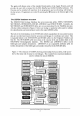
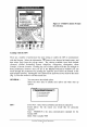
Current map and scale " ' - 'Ie - Hold down pen, wan for beep and draw thick line to measure distance Toggle background map J Toggle Backlight - p.... wiiil / "",wei, ' '112;1.6]1 •• =-0;;;*_ -=a * we=- Double tap on map to create waypoint at tap position GPS status window Single tap on map to show coordinates of tap position 7.(l)0.
Figure 3 - Pull down menu of maps for selection. CO~ Dates Names ®: ~ p Extras... Undo Find =0/" Assist Linking with the GPS There are a number of preferences that need setting to enable the GPS to communicate with the Newton. Select the information CD button in the bottom left hand corner, and then select Prefs from the pop-up menu. The choices available from Prefs include -General, -Global Positioning System, -Map View, -Waypoints, -Navigation, -Data Transfer, -Current Location.
^ Datum: Choose your map datum (e.g., AGD66, WGS84). This must be the same as the map that you are using in the Newton. For GIS usage it is critical to record the datum used. Auto open window: Sets the type of information displayed when the GPS is switched on. Status will show the number, status, and signal strength of satellites visible to the GPS. Position will show the current position as determined by the GPS. There is also a toggle switch to enable averaging.
TRACK LOG -^Allows you to set preferences for track logging. Line Style: Sets the size of the track log position indicators to be displayed in MapPad. Track Interval: Switches track logging on/off, also sets the interval between each position fix when operating in track log mode. Options range from all position fixes received from the GPS unit up to every 10 minutes. Clear Track Log: Press button to clear track log entries.
CURRENT LOC - Gives the current position (or most recent) in degrees and UTM coordinates, as well as the altitude in metres . ... Current Location Degrees Minu1:es Seconds [3IlJ:5mHm.[a]~ [1f4141:5JZH213J.[5][!] [3!2!0!-1-·!8}21 5·!811. !0f4!O!5] UTM mE mN Zone AI1:itude 1. ·.. ···I······· . [5]510 !1·11·1tl m [/ I" ] This button activates a number of options which control the way users interact with the map displayed in MapPad. The flag option is for waypoints.
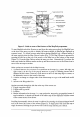
AGSO FieldPad The AGSO FieldPad is a digital notebook for storing field geological data. It can be run without MapPad but then the GPS position will have to be entered manually. There are a number of forms or screens that can be scrolled through by using the up or down arrows located at the bottom of the screen. The dot between the arrows brings up a directory of all the forms. Pressing on the form name will take you straight to the desired form (Figure 6).
Site r····································..AGs<)"f'lei·dPad.. ·········· .... ················..·..··1 i Site ! .DatelTime i I Site ID i FieldlD Figure 7 - site entry form 1 14/6/962:43 PM ......................... _........................... M................. 1; 2.~.~~.~.9..5..................................................... i J.J..9.'.;.J~:.!~.w..~t.t.l. R~§.~.............. _.. I ! .Originator i I:::::~~~~==~-=~:= I !• i .1 Region .5.~...;...MH.r.p~Y...J.~JJ~.~........................
GEOG AREA - Optional free-text field of 64 characters for the geographic area the site is in (e.g., valley, plain, mountain range). Examples include 'Hay Plain', 'Tuggeranong Valley' and 'Selwyn Range'. 1:100K MAP - The 1:100 000 map sheet-area on which the site falls. Mandatory if the country is Australia. (Pulldown menu). 1:250K MAP - The 1:250000 map Sheet area on which the site falls - e.g., 'SF5402' (Pulldown menu).
COORDINATES - Mandatory UTM or latitudellongitude position of the site. Nothing need be done if the GPS connection is operating. It is not recommended, but if have to usc the Newton independently of the GPS live link, then tap the diamond next to Coordinates and modify the position values directly by scrolling the previous numbers up and down to those of the new position.
LAND CODE -^Optional field for the landform (Pulldown Menu). a LANDFORM -^Optional 64-character free-text field for a description of the landform features of the site. Sketch for site • S •• A digital sketch may be attached to a site. Simply draw onto the screen and press the tick to save the sketch. You can use all the editing features of the Newton. Consult the Newton manual for tips on deletion etc. The current limit is one sketch per site.
• buttons at the top of the screen and the Sample ID will 'increment' from A to B and so on. It is recommended that all attributes and structural recordings to a lithology be entered together and that the user return to this screen for subsequent lithologies and their associated attributes and structures. This is because scrolling down to LITHDATA and STRUCTURES (see later) will ensure that the link between this data and rocks is maintained.
MAP SYMBOL Optional field for the map symbol of a lithological unit. This field should only be entered if there is no formal lithostratigraphic unit. It is designed for the type of informal units traditionally used for geological mapping in the Yilgarn Craton and Anmta Province (Pulldown Menu). -^ MODE OF OCC DESC Optional field for the mode of occurrence of a lithology or sample for example 'xenolith' (Pulldown Menu). -^ Optional 64 character free-text field for a description of the lithology.
^ ^ TYPE -^Types are any attribute included in the pulldown menu, such as colour, alteration, thickness, texture (Pulldown Menu). SUBTYPE -^Subtypes are mandatory attribute values unique to each Type (Pulldown Menu). DESC -^This is an optional free-text field of 64 characters for any additional descriptive information relating to the Type/Subtype record. For example, one may wish to comment on the mode of occurrence of a mineral in a sample.
TYPE & SUBTYPE Structural features are stored as a mandatory type and a subtype (e.g., bedding that dips is type 1 subtype 1). We use this system rather than traditional structural systems as it makes map making easier. For example, S, is the second generation fabric but it may be a cleavage, crenulation cleavage, mylonitic fabric and so on. The Type and Subtype system allows the geologist to distinguish the different fabric elements (Pulldown Menu).
['"············ ..·····"··AGso·i'iei·jjp·,,if···············,,·"'''''''''''''''! ! -Site Search ~ [Store) [Delete I I ! Search for: iY: I Search all field5 Search] ...... V' . . . . . . . . 64"6004 96496000 96496005 96,496.001 9t:496006 96,496,002 96.496,003 96496007 Figure 14 - The Site Search form. 96040056 xt i !@~®:~p=o/-I i..~~.~.~: . . .~.:~~.~. . . ~~~~~.~. . ~ Undo Find ASSI$t...
TRANSFERRING DATA TO AND FROM THE NEWTON Apple Newton Backup Utility Install the Apple Newton Backup Utility on your PC or laptop and plug in the Apple Newton serial cable to both the Newton and the PC or laptop. • Checking memory Start the Newton. Before installing a package on the Newton check that there is enough memory 1111^available, either internally or on the flash card. Memory information is available by pressing the icon.
Newton. To upload field sites choose receive text me from the transfers pulldown menu. Next select the directory and file name to which you want to save the uploaded data and press OK. The PC is now read to receive uploaded site records. On the utilities page in FieldPad press the Upload8ookEntries button to commence the data transfer process. Installing lookup tables Provided with each Newton is a disk containing lookup tables copied from the ORACLE database.
^ U rn^ and you will be able to see each line displayed by Slurpee as it is loaded. When a table has finished loading the Newton will make a "werp" sound. Soup loading is a relatively slow process and will take some time for large soups. Loading rates seem to be about 2 lines per second. 8. After loading tables INDEX all the soups via the Utilities form as described. Trouble shooting Error message when a pop-up list is chosen. Sm!) is empty or not indexed. Try indexing the soups.
•• • •• • • •• The only lines that need changing to your specific map sheet are ones with the * symbol. .LYRFiles The lyr files control the visibility and style attributes for layers in a dxffile. Note, it is not necessary to have a .Iyr file to create a map. Style Width TxtFG TxtBG * lCOAST IDRD IDRDUS IFWY 0 1 1 1 1 0 0 0 1 0 0 2 0 0 5 1 1 1 1 1 1 FWYUC 1 1 5 IHWY 1 0 4 IHWYUS 1 1 4 0 0 0 0 0 0 0 0 #Name Include 1 1 1 Comment lines begin with #, and are ignored.
The third and fourth columns specify line style and width. Styles available are 0 Solid 1 Dash 2 Dot 3 Dash Dot 4 Dash Dot Dot The fifth and sixth columns specify text foreground and background colour. 0 1^is Black text on a clear background 1 0^is White text on a solid black background Creating the MapPad Package This programme (Tsmappad.exe) only works on a Windows 95 PC. Go to File and Open your dxf file and select a custom scale then select custom. Wait while the map is created.
•• Acknowledgements We would like to thank David Champion and Sonja Lenz for their critical reviews of early drafts of the manuscript. References Blewett, RS., 1993. The AGSO field geological notebooks - a user's guide. Australian Geological Survey Organisation, Record, 1993/46. Ryburn, RJ., Blewett, RS., Stuart-Smith, P.G., & Williams, P.R., 1993. Users' guide to the NGMA Field Database. Australian Geological Survey Organisation, Record, 1993/47. Ryburn, RJ., Bond, L.D. & Hazell, M.S. 1995.
• • • Appendix 1 - Technical Specifications for Newton 130 3 • Newton Intelligence Newton Recognition Architecture . Recognises handwriting--printed, cursive, or a mixture of the two--with the assistance of a 93,000-word, 111^built-in word list • Lets you add up to 1,000 words III^• Includes four pop-up keyboards: typewriter, numeric, phone, and time/date • Recognises graphics and symmetrical objects 111^ I • Newton Information Architecture • Object-oriented database stores.
• • • • • • Communicates via e-mail or taps into on-line services and the Internet with optional wired or wireless modem cards and software Provides faxing with optional fax modem (automatic cover-page generation, post-formatting) Beams notes, name cards, appointments, and packages at up to 38.