
Specifications


36 Z-Family Technical Reference Manual
using a 24 hour simulation at 0° longitude. GPS geometry is primarily a function of
latitude, and varies only slightly with longitude for a constant latitude.
Mask Angle
The Base station mask angle for RTK messages 18, 19, 20, & 21 is controlled by
$PASHS,ELM. The Base station mask angle for Differential corrections (type 1) is
controlled by $PASHS,PEM. If your data link bandwidth is large enough, then you
can set both mask angles to zero degrees for base stations. This ensures that the base
station will send data for all satellites that it can “see” above the horizon.
If your bandwidth limits the number of satellites for which you can transmit base
station data, then you may raise the mask angle. On baselines less than 100 km, the
remote station sees satellites at approximately the same elevation angles as the base
station sees them, the base station mask angle should be set one degree lower than the
remote mask angle. On long baselines the elevation angle changes by approximately
1° for every 100 km. So for baselines of x*100 km the base station should not have a
mask angle higher than the remote station mask minus x*1°.
The two different controls allow you, for a combined RTK/Differential base station,
to set the mask angles higher for RTK (which typically operates on short baselines)
than Differential (which often operates on longer baselines).
Base Station Position
The RTCM messages 3 and 22 broadcast the base station position to the rover. In case
DBN is used, the position is broadcast via $PASHR,BPS. The base station position
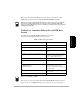
Table 3.10: Maximum Number of Satellites Above a 4° Mask Angle
Latitude
Maximum Number
of GPS SVs
0° 11
10° 12
20° 11
30° 11
40° 11
50° 10
60° 11
70° 12
80° 11
90° 12