
User`s manual


12
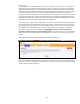
Map Page
To locate your Device at any time, simply log in to the Tracking Portal via your computer or your
Smartphone Applacation (coming soon). Device locations are updated every 5 minutes on the Map
page.
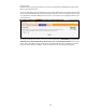
Green Map Marker = current location
Yellow Map Marker = last known location
Red Map Marker = previous locations
Orange Map Markers = SOS Alerts
Blue Man = Predator “Registered Sex Offender”
If the Device cannot obtain a GPS signal, it will pull the last known latitude and longitude coordinates
saved on the Device (last known location). The Map Markers are numbered from 1 to 100, with the
number 1 representing the most current location. If you have not purchased the Predator Alert
service, the Blue Man icon will not appear on your Map page display.
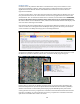
There are two map-viewing options, represented by the bar at the top right-hand corner of the Map.
If you select the Map button, the locations will be displayed in a typical street map format. If you
select the Satellite button, you have the option to view the locations either in satellite form only, or if
you prefer, you may select the drop down box entitled “Labels” to display the street names overlaid
on the satellite image.
To view the address and details of a location, simply click on any map marker, or on the report
related to such map marker. If your screen has been open to the Map page for a period of time,
remember to click the Refresh button to draw down the most current location information.
Features