
Product data


10
Autodesk Design Review Getting Started Guide
Keep Geospatial Data Up to Date
Ensure that you have the most up-to-date, accurate drawings, maps,
and models in the oce or out in the field, at all times. As teams extend
and field forces increase, an easy-to-use electronic distribution system
is crucial for distributing designs. But productivity is a two-way
street. You also need to capture change requests, update the data,
and then electronically send it back.
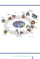
Utilizing DWF technology and Autodesk Design Review software,
you can communicate digitally and receive feedback from extended
team members who don’t typically use computer-aided design (CAD)
software, such as construction crews, field sta, or planners. Among
other formats, Design Review supports standards for design, DWF
and DWG, assuring team members see exactly what is intended.
Easy-to-use tools allow the review, mark up, and tracking of changes
to drawings, maps, and D models, while dramatically reducing
review cycles, cutting costs, and improving team communication.
Team members can communicate changes in context, including
object properties, geo-location, asset utilization, and job tickets.
Add comments, track status, and drag information of any type—site
photos, project timelines, or standards documents—combining them
into a single file. Plus with the tight integration with AutoCAD
®
, and
AutoCAD
®
Map
®
D, and Autodesk
®
MapGuide
®
you can systemati-
cally respond to comments and help ensure that revisions are timely
and comprehensive.