
Technical information


114 | Chapter 7 Importing and Exporting Data in LandXML Format
■ When you select the alignments to export, you can also choose to export
profiles, cross sections, and Interactive Highway Safety Design Model
(IHSDM) data.
■ Use the Export Data Options to control the data precision, the imperial
unit foot type, the units of exported angles and directions, and whether
to export raw descriptions, full descriptions, or both.
■ Use the Export File Options to control the level of detail contained in the
exported file.
■ You can export point references for surfaces, alignments, and parcels.
Point references substitute references to COGO points instead of using
coordinates for the geometric points on an alignment or parcel.
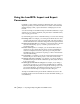
To export data in LandXML format
Steps
Use to locate
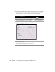
1 From the Projects menu, choose Export LandXML to
display the LandXML Export dialog box.
Exporting LandXML Data
from AutoCAD Land
Desktop
2 Select the data to export by using the Points, Surfaces,
Parcels, and Alignments buttons.
NOTE To export the specified data, the check boxes next
to the Points, Surfaces, Parcels, and Alignments buttons
must be selected. To export pipe run data, the All Pipe
Runs check box must be selected.
Selecting the Point Data to
Export
Selecting the Surface Data
to Export
Selecting the Parcel Data to
Export
Selecting the Alignment
Data to Export
Selecting the Pipe Data to
Export
3 To export point references for surface, parcel, and
alignment geometry, select the Surfaces, Parcels, and
Alignments check boxes under Point References, and then
click Advanced to set the tolerance value.
Changing the Point
Reference Options
4 To set the data precision, the foot type (for imperial
projects only), the units of exported angles and directions,
and how point descriptions are exported, click Data under
Export Options.
Changing the LandXML
Export Data Options