
Technical information

Creating a Grading Plan Using Daylighting Commands | 133
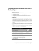
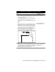
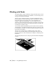
The following illustration shows footprint and daylight line locations.
Creating a Grading Plan Using
Daylighting Commands
To create grading plans, you can use the Daylighting commands, which
determine slope daylighting from a polyline footprint to a surface based on
slope criteria. These commands calculate the daylight match line, which is
drawn as a 3D polyline. Elevational points and breaklines, representing the
daylight slopes, can also be generated. Use all these elements to generate a
surface.
To represent a footprint, use a 2D or 3D polyline with elevational
information. Assign cut and fill slope information to each vertex on the
polyline. You can add more vertices to the polyline for increased daylight line
sampling. Based on the polyline footprint elevations and the assigned slope
information, the daylight line is calculated at each vertex of the footprint
polyline for a selected daylight target surface.