
Technical information

Creating Points | 41
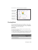
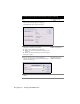
Use the Text tab to control how the point text is displayed.
Creating Points
Use AutoCAD Land Desktop point creation commands to create points in
many ways, such as by northing/easting, along an object, by turned angle,
and so on. You can create points at intersections, on a slope, on alignments,
by referencing a surface, and by interpolating.
Key Concepts
■ Points created by using the commands on the Points menu are always
added to the point database.
■ Point prompts can differ, depending on how you set up the Point Creation
Settings. Use these settings to assign elevations and descriptions to points.
■ To create points by referencing geodetic directions, you must first choose
the current zone for the drawing from the Drawing Setup dialog box.
To create points by northing/easting
Steps
Use to locate
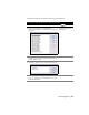
1 From the Points menu, choose Point Settings to display
the Point Settings dialog box.
Control the visibility
of number, elevation,
and description.
Create leaders auto-
matically when
moving point text.
Set the test size rela-
tive to the screen or
an absolute size.
Show full or raw
point descriptions.