
User guide


31
4. Official Designated Airway
5. RNAV Airway
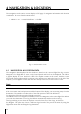
Refer to Section 3.5.12 for detailed information on how to customize the map display settings.
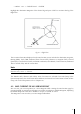
When routing to a specific leg, the Airline Airway, Control Airway, Direct Route Airway and Official
Designated Airway are displayed in blue, while the RNAV Airway (Area Navigation) are displayed
in purple.
Important Note: When the Low Airways are enabled, the Land Elevation (shading) display will be
disabled below the 50 Nm map scale. The land elevation can be determined by moving the cursor
to any area on the map display, and the elevation for that location will be displayed.
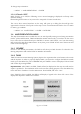
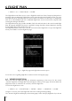
The QUICK INFO window gives you the data that refers to the selected airways. They are:
1. The Low Airways name
2. The outbound course: from the starting point of the selected airway leg
3. The length of the leg
4. The minimum altitude of the leg
In the QUICK INFO window, you may get duplicate information about the same airway. This
duplicate data refers to two different legs. An example of where this may occur is when you
place the CURSOR in the proximity of a User Waypoint or Navigational Aid where the two legs
connect.
In order to view additional data regarding the selected airway; in the Map mode, press the ENTER
key once, select FULL INFO and press ENTER again to confirm, select ‘Enroute Airways’ and
confirm pressing ENTER.
Please Note: The Enroute Airways information displayed in the FULL INFO page may present two
options:
1. Outbound = 0 designates the ending leg of the airway
2. Inbound = 0 designates the starting leg of the airway
In the GOTO menu you can find:
1. SELECT AIRWAY: by selecting this item, you will display the ENTER AIRWAY window. Using the
cursor key, you can edit the Low Airway name.
Note
Once you confirm the selection with the ENTER key, the airway is depicted in black.
2. CLEAR AIRWAY: selecting this item and pressing the ENTER key, the airway color will revert to
the original one.
Controlled Areas: ON/OFF displays/hides controlled areas on the moving map. The default
setting is On.
Restricted Areas: ON/OFF displays/hides restricted areas on the moving map. The default setting
is On.
Display Airspaces
: ALL/Below/Above enables to choose what airspaces cut basing on the threshold
chosen in Airspace Level
Airspaces Level: Sets the Altitude value that conditions the air spaces display if DISPLAY AIRSPACES
is set ABOVE or BELOW. If DISPLAY AIRSPACES is set ALL , AIRSPACE LEVEL is irrelevant.
FIR and UIR: ON/OFF displays/hides FIR and UIR on the moving map. The default setting is
OFF.
MORA
: ON/OFF displays/hides MORA on the moving map. The default setting is OFF.