
User Manual

22
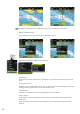
Full
This is all available information for the chart in use.
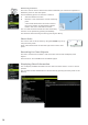
Chart Categories
This option enables you to select which chart categories you want to display on your
chart.
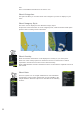
Chart Imagery Style
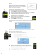
The charts can be displayed in two different imagery styles.
2D presents chart information in a basic mapping mode, while the shaded relief option
presents chart including terrain information.
2D Shaded relief
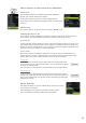
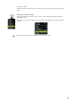
Chart Overlay
Radar and weather information can be displayed as overlay on your chart panel.
When one of the overlay options are selected in the chart context menu it will be
expanded to include basic function for the selected overlay.
Radar, GRIB Weather and Sirius weather functions are described in separate sections in
this manual.
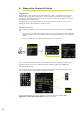
Chart Data
The Zeus system can use Insight and Navionics chart databases.
The Navionics chart includes options that are not available in the
Insight database. Navionics options are described in the following
sections.
MENU WIN
MENU WIN
x2