
Operation Manual


| 67
StructureMap ™ | Zeus Touch Operator Manual
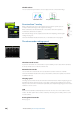
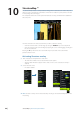
StructureMap sources
Two sources can be used to overlay Structure logs on the charts;
- Live data, used when StructureScan units are connected to the system
- Saved files. These are recorded StructureScan (*.sl2) data that are converted to
StructureMap (*smf) format. Saved *.smf files can be used on units even if no
StructureScan units are connected.
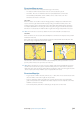
Live source
When live data is selected the SideScan imaging history is displayed as a trail behind the
vessel icon. The length of this trail will vary depending on available memory in the unit
and range settings. As the memory fills up the oldest data will automatically be deleted as
new data is added. When increasing the search range the ping speed of the StructureScan
transducer is reduced, but the width and the length of the image history will be increased.
¼ Note: Live mode does not save any data. If the unit is turned off, all recent data is lost.
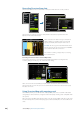
Saved les
When Saved files are selected, the StructureMap file is overlaid on the map based on position
information in the file.
If the chart scale is large, the StructureMap area will be indicated with a boundary box until
the scale is large enough to show Structure details.
Saved mode is used to review and examine StructureMap files, and to position the vessel on
specific points of interest on a previous scanned area.
¼ Note: When saved files are used as source, the display shows all StructureMap files found on
the Micro-SD card and in the system’s internal memory. If there is more than one Structure-
Map of the same area, the images will overlap and clutter the chart. If several logs of the same
area are required, the maps should be put on separate Micro-SD cards.
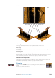
StructureMap tips
- To get a picture of taller structure (a wreck, etc) — don’t drive over it. Steer the boat so the
structure will be on the left or right side of your boat
- Don’t use Autorange when using SideScan. Set your structure range to a significantly
greater level (two-to-three times) than the water depth to ensure a complete scan and to
maximize conversion accuracy
- Don’t overlap history trails when conducting a side-by-side scan of an area