
User`s guide
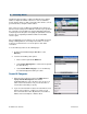


© TELENAV, INC. 2003-2007 PAGE 32 OF 52
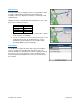
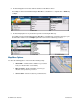
Map Summary
The entire route from your starting location to your destination is drawn
on a map, complete with the latest traffic alerts and traffic flow
information. The route is displayed as a blue line connecting the Start
and Finish flags.
Highways and major roads with traffic flow information are color-coded
by speed in each direction of travel:
Speed Road Color
> 50 mph Green
30 – 50 mph Yellow
< 30 mph Red
Unknown Grey
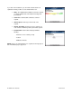
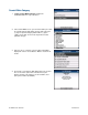
1. Click the trackball/trackwheel to choose “Hide Traffic” or “Show
Traffic” (depends on availability).
2. Use the “*” and “#” keys to zoom in and out of the map. Use the
trackball to pan the map. On trackwheel devices, use the
trackwheel to pan up and down; use the trackwheel while
pressing the ALT key to pan left and right.
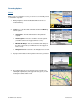
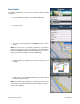
Search Along
Use the Directory to find the desired locations along your navigation
route. For example, find every Mexican restaurant on your route
between San Francisco and Sacramento. This also displays how many
miles off your route each restaurant is. Select a restaurant from the
Search Along list to get driving directions from your current location to
the restaurant.