
User's Manual


Chapter 4: Using the GPS Features
36 BlueTree Wireless BT-2010 Product Manual V1.5
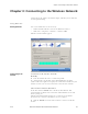
Understanding the GPS
Location work space
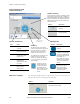
GPS screen examples The following graphical images represent the various screens that you
will typically encounter using BlueVue with GPS.
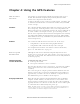
Position Coordinates
Unit Value
Latitude Degrees north or south
of equator.
Longitude Degrees east or west of
Greenwich meridian.
Elevation Elevation from mean
sea elevation. Units:
meters or feet.
Speed Speed of GPS receiver
in motion.Units:
kilometers/hour, miles/
hour, knots.
Track Direction of travel of
GPS receiver in
degrees (true).
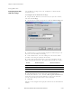
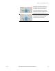
Compass
The direction of the red compass
needle corresponds to the direction of
travel. The direction is reported in
degrees true by the Track value
located in the main GPS screen.
The compass has a granularity of 16
positions. As soon as the GPS
receiver has directional information,
i.e. you are in motion, the compass
will be updated.
As shown at left, the
compass appears as
inactive if directional
information has not
been calculated or if the
GPS receiver is not in
motion,
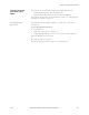
Satellite Tracking
Bars represent the number of satellites currently
being tracked. The GPS receiver is capable of
tracking 8 satellites in orbit. BlueVue displays 12
bars to accommodate the maximum number of
satellites that can be detected according to the
GPS specifications.
Display Represents
Eight satellite signals
received.
No signals received
from any satellite.
Signal Quality
Symbol Description
No satellite signals
detected.
Partial satellite information
available. Incomplete data
received. Only latitude and
longitude location data will
be available, i.e. 2
dimensions only. Accuracy
is low because calculations
are based on last known
altitude.
All GPS information has
been received. Three-
dimensional location
information is available
including elevation.
Time of last
satellite fix
Display GPS State
Modem has just powered on. No satellite
signals have been detected.