
User's Manual


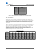
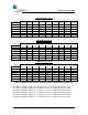
Table Of Contents

TM
GE60 Installation Manual
580-00507, rev 1 9 of 46
Path Length
(meters)
Minimum Clearance
(meters)
250 0.56
500 0.79
750 0.97
1000 1.12
1500 1.37
2000 1.58
Table 2-1: Minimum Clearance at Link Midpoint for various Path Lengths
2.4 Link Distance
Measurement of the link distance is important in estimating the link availability and
calculating expected Receive Signal Level (RSL). This measurement can be performed
using the Latitude and Longitude readings from a Global Positioning System (GPS)
device, which is placed near the proposed locations of the antennas, or using a range
finder device.
Table 2-2 below lists the maximum link distance with respect to desired availability and
ITU rain zone (ITU-R Recommendation PN.837). The map (Figure 2-1) following the
chart shows where the rain zones fit across North America and Asia for various
availabilities and most ITU rain zones. The availability for the AR systems is a
combination of the FE and GE tables of the same type (FE60 and GE60 or FE60X and
GE60X) depending on the current condition of the link.
FE60 Distance Table
(V1545)
Rain Zone
Availability A B C D E F K M N
99.9000% 1470 1440 1420 1350 1400 1350 1280 1140 980
99.9700% 1410 1370 1340 1300 1270 1220 1120 980 820
99.9900% 1360 1280 1230 1180 1140 1080 960 840 710
99.9950% 1310 1220 1170 1100 1050 990 880 770 660
99.9970% 1280 1180 1120 1050 1010 940 830 730 630
99.9990% 1220 1100 1030 960 910 850 750 660 580