
Specifications


The Map file name will be the same name as the image file but with a .MAP extension. The name of
the file can be changed but do not change the extension. Save the file.
Step 3
- The newly created Map will now be opened.
From now on you open the Map by selecting the MAP file using the Load Map from File option. The
original image must always be available when opening the map.
The map calibration used can be viewed using the normal
Check Calibration of Loaded Map
menu
option.
Importing all DRG maps on a CD or in a Folder on your Hard Disk
This option allows you to import all DRG maps from a CD but can also Import DRG maps which
have been copied to a Hard Disk. If you have a USGS CD and copy the image files to the hard disk
you must also copy the fgd files from the metadata directory, place these in the same directory as the
tif files.
Select the
Import Map/All DRG Maps on CD or Folder
Option on the File Menu.
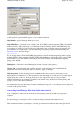
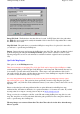
The
Import DRG Maps
dialog will appear.
Image File Path
- The path where the Image files are located. Press the button at the right hand end
of the
Image File Path
field (or enter the Image File Path directly into the field). Select the path
(directory) by browsing the disks.
Map File Path
-
The Path where the created map files will be placed. Press the button at the right
hand end of the
Map File Path
field (or enter the Map File Path directly into the field). Select the
path (directory) by browsing the disks.
Use Geotiff if available
-
If checked and the map images are in Geotiff format and the format is
known then the georeference information will be extracted from the image file.
Press the Import button, the maps will be imported.
The new map files are created in the
Map File Path
you have specified in the configuration.
At the end of the process the number of maps successfully imported (and not imported if any) will be
displayed.
The maps are now ready to use, simply open the map you want to view using the OziExplorer
Load
Map from File
menu option.
Importing DRG's with only a .tfw File
This also applies to JPG files which have a .jgw file, the jgw file is the same as a tfw file, sdw files
can also be used for .SID images, OziExplorer will use these file automatically if it exists.
While not preferred, it is possible to import DRG maps which only have the
.tif
(or other image
format) and a
.tfw
file. There are a lot of parameters missing such as datum, UTM zone number,
scale, map bounding coordinates + others. Most of these can be ignored and set manually after the
map is imported.
Page
121
of
252
OziExplorer Help Contents