
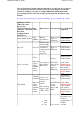
Specifications


It is our intention to support other formats where possible and also to support
more map projections and coordinate grids. For us to support a particular
format we would need a couple of example DEM files, information on the
projection/grid used for the data and the specifications for the format of the
dem file.
See the bottom of this page for details on making your own "default.ozproj" files.
OziExplorer Name
(This is the name
given to the
"Elevation Data Type
and Path" settings in
Elevation
Configuration in
OziExplorer.)
Data
Source
Other Names
Data Spacing
Projection/Grids
Supported
NGA (NIMA) DTED
NGA
(NIMA)
Military
Specification
30 arc seconds
(approx 1
Kilometer)
Data must be in
Lat/Lon with a
WGS84 datum.
Gtopo30 Gtopo30
Similar to the
ArcView BIL
format but the
data file has
a .dem instead
of a .bil
extension
30 arc seconds
(approx 1
Kilometer)
Data must be in
Lat/Lon with a
WGS84 datum.
Globe (ArcView)
Globe
Other data
sources
will be
available
in this
format
Also known as
the ArcView
BIL format
Various
(The Globe
data is 30 arc
seconds
(approx 1
Kilometer))
The default is
Lat/Lon, with a
WGS84 datum.
A file called
default.ozproj
can be setup in
each folder to
specify the
Grid,
Datum
and the
Zone
.
Grid ASCII
AUSLIG
(Australia)
Other data
sources
will be
available
in this
format
Some sort of
ArcView text
format I
believe.
File extension
must be .ASC ,
.GRD , .TXT
Various
(AUSLIG data
is 9 arc
seconds
-
approx. 250
meter)
The default is
Lat/Lon, with a
WGS84 datum.
A file called
default.ozproj
can be setup in
each folder to
specify the
Grid,
Datum
and the
Zone
.
1 deg
dem
3 arc
3 arc second
-
Data must be in
Lat/Lon, a
default datum of
WGS84
assumed.
Page
243
of
252
OziExplorer Help Contents