
Specifications


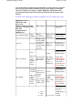


Globe (ArcView)
Grid Ascii
USA DEM 250
USA DEM 24K
See the
Height Data help for more details of the type of data supported.
The checkbox beside each path enables the file type to be made active (used in OziExplorer) or not
active (not used in OziExplorer).
OziExplorer
3D -
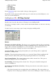
3D Map Control
The 3D Control is used for the creation of 3D maps for use in OziExplorer3D
The creation of 3D maps assumes you have elevation data installed which covers the area of the map
you are using.
Use this Control to create a map or part of a map for display in OziExplorer3D.
Buttons
Draw Box to Set Limit of 3D Map
- This allows a box to be drawn on the map. The area inside the
box can be processed to create a 3D map for display in OziExplorer 3D. To create larger areas of the
map use the zoom function in OziExplorer to zoom out first. Note
-
In unregistered versions of
OziExplorer the creation of 3D maps can only be done at 100% zoom.
Create the 3D Map
- After selecting the map limits (above) the 3D map will be compiled and
transferred to OziExplorer3D.
Grid Size
-
The grid spacing (in image pixels) use to create the 3D map. When compiling the 3D
map an elevation is taken at these points. The grid spacing determines look of the 3D map.
Select Viewing Window
-
The current viewing window will be selected. Note
-
This option is
disabled in unregistered versions of OziExplorer.
Select Full Map
-
The full map will be selected. Note
- This option is disabled in unregistered
versions of OziExplorer.
Select Inside Corner Markers (Neat Line)
-
The map area inside the corner markers (map neat
line) is selected.
The selected area must form a rectangle with corners at 90 degrees. The corner markers on a
map may form a 4 sided polygon where the corners are not at 90 degrees, in these cases the top
Page
248
of
252
OziExplorer Help Contents