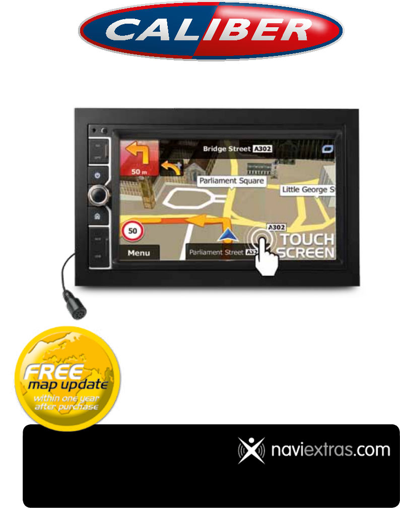
RMN 801BT Navigation Manual • ENGLISH • Navigation map update After the first connection with the GPS satellite, you have one year to update the maps for free! How does it work Go to: www.naviextras.com - Click “Downloads” and download the program “Naviextras Toolbox”. After installing it on your computer, just follow the instructions in the program. Note: you need a cardreader (for SD) and a Naviextras user profile to update your device.You can create a profile on the website, simply go to www.
ENGLISH RMN 801BT Navigation Manual User Manual Navigation software for the Caliber RMN801BT UK English
Navigation Manual Thank you for choosing the Caliber RMN801BT as your navigator. Start using Caliber RMN801BT right away. This document is the detailed description of the navigation software. You can easily discover Caliber while you are using it; however, we still recommend that you read this manual to fully understand the screens and features.
ENGLISH RMN 801BT Navigation Manual Table of contents 1 Warnings and Safety information .........................................................................6 2 Getting started .........................................................................................................7 2.1 Navigation menu ............................................................................................................ 8 2.2 Buttons and other controls on the screen............................................
Navigation Manual 3.1.5 Selecting one of the most likely destinations (Smart History)........................................... 46 3.1.6 Selecting a recent destination from the History ................................................................. 47 3.1.7 Entering the coordinate of the destination ......................................................................... 48 3.1.8 Building a route from the list of destinations (Create Route) ............................................ 50 3.
ENGLISH RMN 801BT Navigation Manual 6.1.9.1 Historical traffic ........................................................................................................................ 78 6.1.9.2 Real-time traffic information (TMC).......................................................................................... 78 6.2 'More' menu.................................................................................................................. 80 6.3 Settings menu .................................
Navigation Manual 1 Warnings and Safety information The navigation system helps you find your way to your destination with the built-in GPS receiver. Caliber does not transmit your GPS position; others cannot track you. If you accept it when first using the application, Caliber collects usage information and GPS logs that may be used for improving the application and the quality and coverage of maps. The data is processed anonymously; no one will be able to track any personal information.
ENGLISH RMN 801BT Navigation Manual 2 Getting started Caliber is optimised for in-car use. You can use it easily by tapping the screen buttons and the map with your fingertips. When using the navigation software for the first time, an initial setup process starts automatically. Do as follows: 1. Select the written language of the application interface. Later you can change it in Regional settings (page 93). 2.
7. Navigation Manual The initial setup is now complete. The Configuration wizard can be restarted later from the Settings menu (page 81). After the initial setup, the Navigation menu appears and you can start using Caliber. 2.1 Navigation menu You can reach all parts of Caliber from the Navigation menu. You have the following options: • to select your destination by entering an address or selecting Tap a place of interest, a location on the map or one of your Favourite destinations.
ENGLISH RMN 801BT Navigation Manual 2.2 Buttons and other controls on the screen When you are using Caliber, you usually tap buttons on the touch screen. You only need to confirm selections or changes if the application needs to restart, it needs to perform a major reconfiguration, or you are about to lose some of your data or settings. Otherwise, Caliber saves your selections and applies the new settings without confirmation as soon as you use the controls.
Slider Navigation Manual When a feature can be set to different values in a range, Caliber shows an indicator on a gauge that displays and sets the value. Virtual keyboard • Drag the handle to move the slider to its new position. • Tap the slider where you want the handle to appear; the thumb jumps there. Alphabetic and Each key is a touch screen alphanumeric keyboards button. to enter text and numbers. 2.2.1 Using keyboards You only need to enter letters or numbers when you cannot avoid it.
ENGLISH RMN 801BT Navigation Manual Finalising the keyboard entry (saving your input) Cancelling the keyboard entry (returning to the previous screen) Tap . Tap . 2.2.2 Beyond single screen tap You usually need to tap the screen only once. However, some useful features can be accessed with combined touch screen tapping. Those are the following: Action Tapping and holding the screen Details Tap and keep pressing the following buttons to reach extra functions: • Tap and hold Map screen appears.
Navigation Manual 2.3 Map screen 2.3.1 Navigating on the map The Map screen is the most frequently used screen of Caliber. A small live map is displayed on the Navigation menu, as a part of the button. To enlarge this small map and open the Map screen, tap . This map shows the current position (the Vehimarker, a blue arrow by default), the recommended route (an orange line), and the surrounding map area. When there is no GPS position, the Vehimarker is transparent. It shows your last known position.
ENGLISH RMN 801BT Navigation Manual The data fields are different when you are navigating an active route and when you have no specified destination (the orange line is not displayed). Default data fields when cruising without a destination (tap and hold any of the fields to change its value): Field Description Shows your current speed given by the GPS receiver. Shows the speed limit of the current road if the map contains it. Shows the current time corrected with time zone offset.
Navigation Manual 2.3.2 Position markers 2.3.2.1 Vehimarker and Lock-on-Road When your GPS position is available, Caliber marks your current position with the Vehimarker. This marker is a blue arrow. When on-road navigation is selected, the Vehimarker may not show your exact GPS position and heading. If roads are near, it is aligned to the nearest road to suppress GPS position errors, and the direction of the icon is aligned to the direction of the road.
ENGLISH RMN 801BT Navigation Manual 2.3.3.2 Turn preview and Next street When navigating a route, the top section of the Map screen shows information about the next route event (manoeuvre) and the next street or the next city/town. There is a field in the top left corner that displays the next manoeuvre. Both the type of the event (turn, roundabout, exiting motorway, etc.) and its distance from the current position are displayed.
Navigation Manual Enter motorway. Exit motorway. Board ferry. Leave ferry. Approaching a waypoint. Approaching the destination. 2.3.3.3 Lane information and Signposts When navigating on multilane roads, it is important to take the appropriate lane in order to follow the recommended route. If lane information is available in the map data, Caliber displays the lanes and their directions using small arrows at the bottom of the map. Highlighted arrows represent the lanes you need to take.
ENGLISH RMN 801BT Navigation Manual 2.3.3.4 Junction view If you are approaching a motorway exit or a complex intersection and the needed information exists, the map is replaced with a 3D view of the junction. The lanes you need to take are displayed with arrows. Signposts can also be present if information is available. If you want to hide the currently displayed junction, tap the picture and the Map screen returns. 2.3.3.
Navigation Manual 2.3.3.6 3D object types Caliber supports the following 3D object types: Type 3D terrain Description 3D terrain map data shows changes in terrain, elevations or depressions in the land when you view the map in 2D, and use it to plot the route map in 3D when you navigate. Hills and mountains are shown in the background of the 3D map, and illustrated by colour and shading on the 2D map.
ENGLISH RMN 801BT Navigation Manual 2.3.3.8 Traffic events Road segments affected by traffic events are displayed with an alternate colour on the map, and small symbols above the road show the nature of the event: to open the Traffic Summary screen. 1. Tap 2. Tap 3. Tap the traffic category you are interested in, or tap of all events: 4. Now tap any of the list items to see its details, and to display the affected road segment in its full length on the map: to open the list of event categories.
Navigation Manual 2.3.4 Manipulating the map Tap the map anywhere to browse it during navigation. The map stops following the current position (the Vehimarker, a blue arrow by default, is not locked in a fix position on the screen any more) and control buttons appear to help you modify the map view.
ENGLISH RMN 801BT Navigation Manual Location information Return to normal navigation Tap this button to open a new screen with information about the selected map point, the Cursor. Tap this button to move the map back to follow the current GPS position. Automatic map rotation is also reenabled. The map manipulation navigation continues.
This button opens the route editing function. Navigation Manual My Route / Edit Route This button opens the route related settings. More / Settings / Route Settings (page 85) This button opens the map related settings. More / Settings / Map Settings (page 90) Tap the Current Street This button opens a special screen with information about the current position and a button to search for field on the Map screen nearby emergency or roadside assistance. For details, see the next chapter.
ENGLISH RMN 801BT Navigation Manual My Route / More / Save With this function you can save the active route for later Route use. My Route / More / Load With this function you can replace the active route with a Route previously saved route. Find / Find Places (page With this function you can search for Places of Interest in 34) various different ways. My Route / More / This button opens the Map screen and starts simulating Simulate Navigation the active route.
• Open the Quick menu and tap the Navigation Manual button. Information on this screen: • , : Latitude and Longitude (coordinate of the current position according to the widely used WGS84 format). • : Altitude (elevation information coming from the GPS receiver - often inaccurate). • • : House number on the left. : House number on the right. • In the middle of the screen you can see whether the position is current, or the time left since it was last updated.
ENGLISH RMN 801BT Navigation Manual 3 On-road navigation When first started, Caliber calculates routes using the road network of the high quality vector maps provided with the product. You can set up your route in different ways: • If you need a route for immediate navigation, you can select the destination and start navigating to it right away (normal navigation). • You can also plan a route independently of your current GPS position or even without GPS reception.
Navigation Manual 3.1.1.1 Entering an address To enter an address as the destination, do as follows: to return to the Navigation 1. If you are on the Map screen, tap menu. 2. In the Navigation menu, tap the following buttons: 3. By default, Caliber proposes the country and city/town where you are. If needed, tap , . , enter the first few letters of the country name on the keyboard, and select one country from the list of results. 4. Select a new city/town: . a. Tap b.
ENGLISH RMN 801BT Navigation Manual • If the desired name does not show up, the names that match the string appear in a list after entering a couple of characters (to open the list of ). Select results before it appears automatically, tap the street from the list. 6. 7. Enter the house number: . a. Tap b. Enter the house number on the keyboard. (To enter letters, tap c. to finish entering the address.
Navigation Manual 3.1.1.2 Entering the midpoint of a street as the destination You can navigate to the midpoint of a street if the house number is not available: to return to the Navigation 1. If you are on the Map screen, tap menu. 2. In the Navigation menu, tap the following buttons: 3. If necessary, modify the country and city/town as described earlier (page 26). 4. Enter the street name: , . . a. Tap b. Start entering the street name on the keyboard. c.
ENGLISH RMN 801BT 7. Navigation Manual After a short summary of the route parameters, the map appears showing the entire route. The route is automatically calculated. Tap parameters, or tap to modify route and start your journey. 3.1.1.3 Selecting an intersection as the destination To enter an address as the destination, do as follows: to return to the Navigation 1. If you are on the Map screen, tap menu. 2. In the Navigation menu, tap the following buttons: 3.
• 6. Navigation Manual In case of a longer street, the keyboard screen appears. Start entering the name of the intersecting street on the keyboard. As soon as the street names that match the entered string can be shown on one screen, their list appears automatically. Select from the list. A full screen map appears with the selected point in the middle. If necessary, tap the map somewhere else to modify the destination. The Cursor ( location.
ENGLISH RMN 801BT c. Navigation Manual Find the city/town you need: • The most likely city/town name is always shown in the input field. To accept it, just tap the field you entered the first letters in. • If the desired name does not show up, the names that match the string appear in a list after entering a couple of characters (to open the list of results before it appears automatically, tap the city/town from the list. ). Select 5. .
Navigation Manual 3.1.1.5 Entering an address with a postal code All of the above address searching possibilities can be performed with entering the postal code instead of the city/town name. Find below an example with a full address: to return to the Navigation 1. If you are on the Map screen, tap menu. 2. In the Navigation menu, tap the following buttons: 3. If necessary, modify the country as described earlier (page 26). 4. Enter a new city/town using its postal code: a. . .
ENGLISH RMN 801BT Navigation Manual • If the desired name does not show up, the names that match the string appear in a list after entering a couple of characters (to open the list of results before it appears automatically, tap the street from the list. 6. 7. ). Select Enter the house number: . a. Tap b. Enter the house number on the keyboard. (To enter letters, tap c. to finish entering the address.
Navigation Manual 3.1.1.6 Tips on entering addresses quickly • • When you are entering the name of a city/town or a street: • Only those letters are offered on the keyboard that appear in possible search results. All other characters are greyed out. • As you are typing, the most likely result is always displayed in the input field. If the guess is correct, just tap to select it. • After entering a couple of letters, tap contain the specified letters.
ENGLISH RMN 801BT Navigation Manual 3.1.2.1 Quick search for a Place of Interest The Quick search feature lets you quickly find a Place by its name. The search is always carried out along the recommended route if it exists or around your current location if there is no destination given. 1. Start the Quick search function. • If you are on the Map screen, tap • If you are in the Navigation menu, tap tap and then tap . , and then . 2. Using the keyboard, start entering the name of the Place.
7. If necessary, tap the map somewhere else to modify the destination. The Cursor ( ) appears at the new location. Tap destination, or tap 8. Navigation Manual to confirm the to select a different destination. After a short summary of the route parameters, the map appears showing the entire route. The route is automatically calculated. Tap parameters, or tap to modify route and start your journey. 3.1.2.
ENGLISH RMN 801BT Navigation Manual • If there is no active route (destination is not selected), they are searched around the current position. • If the current position is not available either (no GPS signal), they are searched around the last known position. • If an active route exists, restaurants are searched along the route. • If there is no active route (destination is not selected), they are searched around the current position.
9. Navigation Manual After a short summary of the route parameters, the map appears showing the entire route. The route is automatically calculated. Tap parameters, or tap to modify route and start your journey. 3.1.2.3 Searching for a Place of Interest by category You can search for Places of Interest by their categories and subcategories. to return to the Navigation 1. If you are on the Map screen, tap menu. 2. In the Navigation menu, tap the following buttons: 3. Tap 4.
ENGLISH RMN 801BT • Navigation Manual to search for a place around the destination of the Tap active route. (The result list will be ordered by the distance from the destination.) , select the city/town to search in. 5. (optional) If you have selected 6. Select one of the main Place categories (e.g. Accommodation) or tap to list all Places around the selected location or along the route. 7. Select one of the Place subcategories (e.g.
8. Navigation Manual Sometimes the list of brands in the selected Place subcategory appears. Select one brand or tap to list all Places in the selected subcategory around the selected location or along the route. 9. 10. Finally, the results appear in a list. (optional) The Places in the list are ordered by their distance from the current or last known position, from the selected city/town, from the destination or by the length of the necessary detour. If you need to reorder the list, tap . 11.
ENGLISH RMN 801BT Navigation Manual 3.1.2.4 Searching for a Place of Interest by name You can search for Places of Interest by their names. You can search around different locations or along your route in the whole Place database or in one Place category or subcategory only. to return to the Navigation 1. If you are on the Map screen, tap menu. 2. In the Navigation menu, tap the following buttons: 3. Tap 4. Select the area around which the Place should be searched for: 5. , . .
6. Navigation Manual Select one of the main Place categories (e.g. Accommodation) to search in or tap to search among all Places. 7. Select one of the Place subcategories (e.g. Hotel or Motel) to search in or tap to search in the selected Place category. if you have not done it before. 8. Tap 9. Using the keyboard, start entering the name of the Place. 10. to open the list of Places with After entering a few letters, tap names containing the entered character sequence.
ENGLISH RMN 801BT 11. Navigation Manual (optional) The Places in the list are ordered by their distance from the current or last known position, from the selected city/town, from the destination or by the length of the . necessary detour. If you need to reorder the list, tap 12. to see the details of the selected Place. Tap (optional) Tap to return to the map. 13. If necessary, tap the map somewhere else to modify the destination. The Cursor ( ) appears at the new location.
3. Navigation Manual Preset search categories appear, all for searching around the current position (or around the last known position if the current position is not available): • : Car repair and roadside assistance services • : Medical and emergency services • : Police stations • : Petrol stations 4. Tap any of the quick search buttons to get an instant list of that type of Places. 5.
ENGLISH RMN 801BT Navigation Manual 3.1.3 Selecting a map location as the destination 1. If you are on the Map screen, tap menu. to return to the Navigation 2. In the Navigation menu, tap the following buttons: 3. Locate your destination on the map: move and scale the map as needed. 4. Tap the location that you want to select as your destination. The Cursor ( appears there. , . ) to select the Cursor as the destination. 5. Tap 6.
Navigation Manual 2. Tap . The list of Favourite destinations is displayed. 3. Tap the Favourite that you want to set as your destination. If necessary, browse down to see more of the list or tap name of the Favourite destination. 4. and enter a few letters from the A full screen map appears with the selected point in the middle. If necessary, tap the map somewhere else to modify the destination. The Cursor ( location.
ENGLISH RMN 801BT Navigation Manual . 2. In the Navigation menu, tap 3. Tap the 4. A full screen map appears with the selected point in the middle. If necessary, tap the or the destination in the History field. map somewhere else to modify the destination. The Cursor ( location. Tap ) appears at the new to confirm the destination, or tap to select a different destination. 5. After a short summary of the route parameters, the map appears showing the entire route.
2. Navigation Manual The list of recent destinations appears. Smart History promotes three destinations to the first page based on your previous routes (most likely destinations). The rest of the destinations are ordered by time they were last selected. If necessary, scroll the list to see earlier destinations. 3. Select a destination from the list. 4. A full screen map appears with the selected point in the middle. If necessary, tap the map somewhere else to modify the destination.
ENGLISH RMN 801BT Navigation Manual 4. You can enter the latitude and longitude values in any of the following formats: decimal degrees; degrees and decimal minutes; or degrees, minutes and decimal seconds. 5. (optional) If necessary, tap the coordinate in UTM format. then and enter . 6. When finished, tap 7. A full screen map appears with the selected point in the middle. If necessary, tap the map somewhere else to modify the destination. The Cursor ( location.
Navigation Manual 3.1.8 Building a route from the list of destinations (Create Route) You can also build your route destination by destination from the My Route menu. to return to the Navigation 1. If you are on the Map screen, tap menu. 2. In the Navigation menu, tap 3. Tap 4. There is only one line in the list of route points, the start point of the route, normally the current GPS position. 5. Tap 6.
ENGLISH RMN 801BT Navigation Manual 3.2 Viewing the entire route on the map It is easy to get a map overview of the active route. Do as follows: to return to the Navigation 1. If you are on the Map screen, tap menu. 2. In the Navigation menu, tap 3. . The active route is displayed in its full length on the map Tap together with additional information and controls. . 3.
4. Navigation Manual You have the following options on this screen (for detailed instructions on how to use them, see the next chapter): • to edit the route: to add or remove destinations or Tap change their sequence. You can also set a route start point other than your current location. This can be useful to plan and save a future trip. • Tap to display the entire route on the map. • Tap to bypass a part of the route. • Tap to delete the active route.
ENGLISH RMN 801BT Navigation Manual • Tap to add the newly selected location as an intermediate destination to your route. The other destinations of the route remain intact. Note: the new waypoint is placed among destinations to keep the route optimal. To decide where a waypoint to appear, use the Edit Route feature. • to append the newly selected destination at the end of the route. The Tap other destinations of the route remain intact. The previous final destination is now the last waypoint. 3.4.
5. Navigation Manual The Destination menu appears and you can select the start point of the route the same way you select a destination. . 6. When the new start point is set, tap 7. The map returns with a transparent Vehimarker (showing that there is no GPS reception). If an active route already existed, it is now recalculated starting from the selected location. 8. To return to normal navigation, tap . 3.4.
ENGLISH RMN 801BT Navigation Manual • Tap to delete a destination. • Tap to modify the start point of the route. • to reorder the list. You can do it manually or you can Tap let the application optimise the route for you. 3.4.4 Pausing the active route You do not need to pause the active route: when you start driving again, Caliber restarts the voice instructions from your position. 3.4.
2. Tap . . Navigation Manual 3. Tap 4. You see the basic details of three route alternatives with the selected route planning method. Tap any of them to see it on the map. 5. Or if you cannot find a good alternative, tap routes with different routing methods. 6. to return to the Select one of the route alternatives and tap previous screen. Caliber recalculates the route. The orange line now shows the new recommended route.
ENGLISH RMN 801BT Navigation Manual 3.4.7 Checking route alternatives for an existing route To recalculate the active route with a different route planning method, you can modify the Route settings (page 85). There is another way to do this and to compare different route alternatives with the same route planning method. Do as follows: to return to the Navigation 1. If you are on the Map screen, tap menu. 2. In the Navigation menu, tap 3. Tap . 4. Tap . 5.
Navigation Manual and scroll down for 6. Or if you cannot find a good alternative, tap routes with different routing methods. 7. for a few Select one of the route alternatives then tap and hold seconds to return to the Map screen. Caliber recalculates the route. The orange line now shows the new recommended route. 3.4.8 Changing the vehicle used in route planning To recalculate the active route for a different vehicle, do as follows. These changes can also be made in Settings (page 85). 1.
ENGLISH RMN 801BT Navigation Manual 3.4.9 Changing the road types used in route planning To recalculate the active route with different road type preferences, do as follows. These changes can also be made in Settings (page 85). and then tap . 1. On the Map screen, tap 2. Tap any of the listed road types to modify the route. If needed, scroll the list for all road types. You have the following options (their order depends on the selected vehicle type): 3.
Navigation Manual 3.5 Saving a location as a Favourite destination You can add any location to Favourites, the list of frequently used destinations. Planning a route to one of the Favourite destinations is described on page 45. 1. Select a destination as described before. It can be an address, a Place, any location on the map, a previously used destination from History, etc. 2. When the full screen map appears with the selected location in the middle, tap . . 3. Tap 4.
ENGLISH RMN 801BT Navigation Manual 3.5.1 Editing the details of a Favourite destination You can select a location that you have already saved as a Favourite and edit its details. Adding a location to the list of Favourite destinations is described on page 60. 1. Access the list of Favourites: • If you are on the Map screen, tap • If you are in the Navigation menu, tap and then tap . and then tap . 2. The list of Favourite destinations is displayed. 3. Tap the Favourite that you want to edit.
Navigation Manual 3.6 Saving a map location as an alert point You can save any map location as an alert point (for example a speed camera or a railway crossing). 1. Browse the map and select a location. The red Cursor appears there. 2. Tap . . 3. Scroll down the list and tap 4. On the newly opened screen, select the type of the alert point, the direction from which you expect the alert, and (if applicable) the speed limit for this alert point. 5. Tap to save the location as a new alert point.
ENGLISH RMN 801BT Navigation Manual 3.7 Editing an alert point You can edit a previously saved or uploaded alert point (for example a speed camera or a railway crossing). 1. Browse the map and select the alert point to edit. The red circle appears around the alert point. 2. Tap . . 3. Scroll down the list and tap 4. On the newly opened screen, modify the type of the alert point, the direction from which you expect the alert, or (if applicable) the speed limit for this alert point. 5.
Navigation Manual 3.8 Watching the simulation of the route You can run a simulated navigation that demonstrates the active route. Do as follows: to return to the Navigation 1. If you are on the Map screen, tap menu. 2. In the Navigation menu, tap 3. Tap 4. . The simulation starts from the Scroll down the list and tap starting point of the route, and using a realistic speed, it leads you through the whole recommended route. . . a.
ENGLISH RMN 801BT • • b. Tap Navigation Manual : Jump to the previous route event (manoeuvre). : Tap to increase the speed of the simulation to 4, 8 or 16 times faster. Now tap again to return to the normal speed. to stop the simulation.
Navigation Manual 4 Off-road navigation When first started, Caliber calculates routes using the road network of the high quality vector maps provided with the product. You can switch the application to off-road mode in Navigation settings in one of the following ways:You can switch the application to off-road mode in the following way: • , From the Main menu, tap , and then . • From the Map screen, tap , and then .
ENGLISH RMN 801BT Navigation Manual 5 Lorry navigation The navigation software gives more options for lorry drivers: • You can enter the parameters of your vehicle and Caliber calculates your routes with taking available weight, height, etc.
Navigation Manual 3. Tap . 4. Tap . 5. There is one Default Lorry profile at the end of the list. You can either: 6. button at the Default Lorry profile or • tap the • create a new profile by tapping and selecting Lorry as the vehicle type. then The list of vehicle profile parameters appear. Scroll the list and tap any of the lines to change the parameters. The parameters are intuitive.
ENGLISH RMN 801BT 7. Navigation Manual When finished with the vehicle parameters: • tap if you have modified an existing vehicle profile or • tap if you have created a new profile. While this profile is selected, the parameters of your vehicle are taken into account when planning routes. Note that this leads to a safe route for your lorry only if map data contains the weight, height, etc. restrictions of the road network in your area.
3. Tap . 4. Tap to enable or disable this option. 5. When finished, tap and hold Navigation Manual to return to the Map screen. 5.3 Setting up driving time alerts In order to obey the regulations regarding continuous and daily driving, you can set countdown timers to alert you when you need a break or a sleep. This feature can be set for one driver or two alternate drivers. to return to the Navigation 1. If you are on the Map screen, tap menu. 2. In the Navigation menu, tap 3. Tap . 4.
ENGLISH RMN 801BT Navigation Manual 5. (optional) Tap the switch to use the vehicle with two drivers. The timer defaults are the same but the timers will count down for each driver individually. 6. When finished, tap and hold to return to the Map screen. Whenever the vehicle stops, the current driver receives a message a few minutes later whether this stop means a break.
Navigation Manual 6 Reference Guide On the following pages you will find the description of the different concepts and menu screens of Caliber. 6.1 Concepts 6.1.1 Smart Zoom Smart Zoom provides much more than just a usual automatic zoom feature: • while following a route: when approaching a turn, it will zoom in and raise the view angle to let you easily recognise your manoeuvre at the next junction.
ENGLISH RMN 801BT Navigation Manual After leaving the tunnel, the original map view returns. This feature can be turned off in Settings (page 91). 6.1.4 Route calculation and recalculation Caliber calculates the route based on your preferences: • • Route planning methods: • : Gives a quick route if you can travel at or near the speed limit on all roads. Usually the best selection for fast and normal cars. • : Gives a route that has the smallest total distance of all possible routes.
• Walkways are excluded from routes. • Manoeuvre restrictions and directional constraints are taken into account when planning a route. • Roads are used only if access for buses is allowed. • Private roads, resident-only roads and walkways are excluded from routes. • Manoeuvre restrictions and directional constraints are taken into account when planning a route. • Roads are used only if access for taxis is allowed. • Private roads, resident-only roads and walkways are excluded from routes.
ENGLISH RMN 801BT Navigation Manual 6.1.5 Green routing Route calculation is not only about finding the quickest or shortest route. For some of the vehicle types, you can also check the fuel consumption and CO2 emission when planning a route, and you can create cost effective routes with less effect on the environment. In Route settings, you can edit the parameters of the selected vehicle. Enter the fuel consumption values and the price of the fuel.
• Navigation Manual Visual warning: the type of the alert point, its distance and the related speed limit appear on the Map screen while you are approaching one of these cameras. For some of the alert points, the enforced or expected speed limit is available. For these points, the audio alert can be different if you are below or above the given speed limit. • Only when speeding: The audio alert is only played when you exceed the given speed limit.
ENGLISH RMN 801BT Navigation Manual Caliber is connected to the GPS receiver, but the signal is too weak and the receiver cannot determine the GPS position. GPS navigation is not possible. Only a few satellites are received. Position information is available, but elevation (altitude) cannot be calculated. GPS navigation is possible, but the position error may be significant. Altitude information is available, the position is a 3D position. GPS navigation is possible. 6.1.
Navigation Manual 6.1.9.1 Historical traffic If statistical traffic information is stored with the map data, Caliber can take them into account when planning a route. In normal cases, these statistics help you avoid usual traffic jams on the given day of week in the given hour but in some cases like on public holidays that fall on normal weekdays, they can be misleading. You can disable this feature in Traffic settings (page 85).
ENGLISH RMN 801BT Navigation Manual to open the Traffic Summary screen: 1. Tap 2. Tap 3. Tap the traffic category you are interested in, or tap of all events: 4. Now tap any of the list items to see its details, and to display the affected road segment in its full length on the map: to open the list of of event categories.
Navigation Manual 6.2 'More' menu The 'More' menu provides you with various options and additional applications. Tap the following buttons: , Button . Description You can configure the program settings, and modify the behaviour of Caliber. Finetune route planning options, change the look of the Map screen, turn on or off warnings, or restart the Configuration wizard, etc. See the next chapter for details. Visit www.naviextras.
ENGLISH RMN 801BT Navigation Manual 6.3 Settings menu You can configure the program settings, and modify the behaviour of Caliber. Tap the following buttons: , , The Settings menu has several options. Tap . or scroll with your finger to see the full list. Button Description Adjust the sound volume, mute your device or change the voice guidance language. In addition, you can enable and set up different warnings and alerts. The content of the Quick menu (page 21) is fully customisable.
Navigation Manual Display related settings include menu animations and separate skins for daytime and night use. These settings allow you to customise the application for your local language, measurement units, time and date settings and formats, as well as to choose the time zone. Trip logs and track logs contain useful information about your trips. Trip logs can be saved manually when you reach your destination or you can turn on the automatic saving here.
ENGLISH RMN 801BT Navigation Manual Maps may contain information about the speed limits of the road segments. Caliber is able to warn you if you exceed the current limit. This information may not be available for your region (ask your local dealer), or may not be fully correct for all roads in the map. The maximum speed set in the vehicle profile is also used for this warning. Caliber alerts you if you exceed the preset value even if the legal speed limit is higher.
Navigation Manual You can control the volume of the following sound types: Button Description This is the main volume control. These controls affect all below sounds. These controls affect the volume of the guidance sounds (verbal instructions). Turn off the attention tone preceding verbal instructions or adjust its volume. These controls affect the volume of the non verbal alert sounds (beeps). Key sounds provide audible confirmation of tapping the touch screen. These controls affect key sounds.
ENGLISH RMN 801BT Navigation Manual 6.3.4 Traffic settings The recommended route is not always the same between two points. Whenever suitable data exists, traffic information can be taken into account in the route calculation. Button Description Use this switch to enable or disable historical traffic data and traffic patterns.
Navigation Manual screen, and the part of the route not matching your preference will be displayed in a different colour on the map. In the list of road types you can see in how many segments and what total length of the road type is used in the current route. Button Description You might need to avoid motorways when you are driving a slow car or you are towing another vehicle. Charge roads are pay roads where you can purchase a pass or vignette to use the road for a longer period of time.
ENGLISH RMN 801BT Navigation Manual When creating a new vehicle profile, first you need to select the vehicle type. Then you need to set the following parameters (some of them may not exist for the selected vehicle type). You can modify the same parameters when you edit an existing profile: Button Description Tap this button to rename the profile for something meaningful. Enter the average consumption of your vehicle when used in built-up areas. The unit for consumption can be set in Regional Settings.
Navigation Manual Vehicle types: When creating a new vehicle profile, select one of the below vehicle types. Besides the below mentioned conditions, dimension, weight and freight hazard restrictions can also be taken into account when planning a route. : • • Manoeuvre restrictions and directional constraints are taken into account when planning a route. • Roads are used only if access for cars is allowed.
ENGLISH RMN 801BT Navigation Manual Route Planning Method types: Button Description Gives a quick route if you can travel at or near the speed limit on all roads. Usually the best selection for fast and normal cars. Gives a short route to minimise the distance to travel. It can be practical for slow vehicles. Searching for a short route regardless of the speed, this route type is rarely practical for normal vehicles.
Navigation Manual 6.3.7 Map settings You can fine-tune the appearance of the Map screen. Adjust the map view to your needs, choose suitable colour themes from the list for both daytime and night use, show or hide 3D buildings, turn track logging on or off, and manage the visibility of Place markers (which Places to show on the map). The map is always shown on the screen so that you can see the effect when you change a setting.
ENGLISH RMN 801BT Navigation Manual Select which Places to show on the map while navigating. Too many Places make the map crowded so it is a good idea too keep as few of them on the map as possible. For this, you have the possibility to save different Place visibility sets. You have the following possibilities: • Tap the checkbox to show or hide the Place category. • Tap the name of the Place category to open the list of its subcategories.
Navigation Manual Turn on the route progress bar to see your route as a straight line on the left side of the map. The blue arrow represents your current position and moves up as you travel. Waypoints and Traffic events are also displayed on the line. When you slow down while driving on a motorway, there is a chance that you are in a traffic jam so Caliber offers you a detour using the next exit.
ENGLISH RMN 801BT Navigation Manual Adjust the display backlight. 6.3.10 Regional settings These settings allow you to customise the application for your local language, measurement units, time and date settings and formats, as well as to choose the time zone. Button Description This button displays the current written language of the user interface. By tapping the button, you can select a new language from the list of available languages.
Navigation Manual 6.3.12 Log collection settings If you accept this when first using the application, it collects usage information and GPS logs that may be used for improving the application and the quality and coverage of maps. The data is processed anonymously; no one will be able to track any personal information. Here you can enable or disable collecting these logs. Anonymous statistical information on using the navigation software is collected for later development purposes.
ENGLISH RMN 801BT Navigation Manual 7 Glossary 2D/3D GPS reception The GPS receiver uses satellite signals to calculate its (your) position and needs at least four signals to give a three-dimensional position, including elevation. Because the satellites are moving and because objects can block the signals, your GPS device might not receive four signals.
Navigation Manual North-up map orientation In North-up mode the map is rotated so its top always faces North. This is the orientation for example in Find on Map. Road Safety Camera Special alert points for speed, red light or bus lane cameras. Different data sources are available. You can configure Caliber to warn you when you approach one of these cameras. Detecting the location of Road Safety Cameras is prohibited in certain countries.
ENGLISH RMN 801BT Navigation Manual 8 Copyright note The product and the information contained herein are subject to change without prior notification. This manual may not, in whole or in part, be reproduced or transmitted in any form either electronically or mechanically, including photocopying and recording, without the express written consent of Caliber. © 2016 - Caliber © 2006 – 2016 TomTom. All rights reserved.
Navigation Manual ENGLISH RMN 801BT
W W W.C A L I B ER . N L Caliber Head Office • The Netherlands • Fax: +31 (0)416 69 90 01 • E-mail: info@caliber.