
Owner's Manual
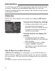


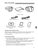
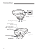
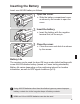
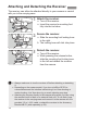
Table Of Contents
- Instruction Manual
- Introduction
- Features
- Using This Manual
- Table of Contents
- Supplied Accessories
- Parts & Controls
- Inserting the Battery
- Attaching and Detaching the Receiver
- Turning the Receiver On
- Acquiring GPS Signals
- Geotagging Images as You Shoot
- Logging the Route Traveled
- Setting the Positioning Interval
- Using the Digital Compass
- Setting Time from GPS on the Camera
- GPS Precautions
- Provided Software
- Using a Bracket (Sold Separately)
- Specs
- Scan of CD-ROM
- Warranty

Features
4
Supported by cameras that display [GPS device settings] in the
menu, except the EOS 7D.
The camera time can be set using GPS signals. On the EOS-1D X,
high-precision adjustment is performed with a margin of error of
approx. ±0.02 second relative to UTC time, and on other cameras,
the margin is approx. ±1 second.
Shooting locations and the route traveled with the receiver can be
viewed on a virtual map, using the Map Utility software on the
provided CD-ROM.
Images can be tagged with location
information recorded in logging mode
(p.3). You can geotag JPEG and
RAW images (file extension: CR2)
shot with EOS DIGITAL cameras
(p.11).
Setting the Camera Time
Viewing Images on a Virtual Map
Geotagging Images on a Computer
Map data ©2012 ZENRIN -
Map data ©2012 ZENRIN -