
Instruction Manual


G-13
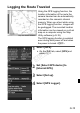
Using the GPS logging function, the
location information of the route the
camera traveled can be automatically
recorded on the camera’s internal
memory. When you shoot while using
the GPS logging function, images will
be geotagged. The recorded location
information can be viewed on a virtual
map on a computer using the Map
Utility software (p.G-18).
The GPS logging function is enabled
even during auto power off and when
the power is turned <2>.
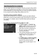
1
Select [GPS].
On the [52] tab, select [GPS] and
press <0>.
2
Set [Select GPS device] to
[Internal GPS].
3
Select [Set up].
4
Select [GPS Logger].
Logging the Route Traveled
Map data ©2012 ZENRIN -
COPY