User Guide B430 5th edition www.binatonegps.
IMPORTANT IMPORTANT Satellite signals are required for this product to function in Navigation Mode. There may be occasions within your home or surrounding area when the signal strength is limited and Navigation may not be possible. This is quite normal for product of this type. You can check the number of satellite signals that the unit is receiving and the strength of those signals by viewing the GPS Receiver. If you need help....
SAFETY Safety The Global Positioning System The Global Positioning System (GPS) is a satellite based system that provides location and timing information around the globe. GPS is operated and controlled under the sole responsibility of the Government of the United States of America, who are responsible for its availability and accuracy. Any changes in GPS availability and accuracy, or in environmental conditions, may impact the operation of you Binatone Carrera Personal Navigation Device (PND).
CONTENTS CONTENTS Important………………………………………………………………………. In the Box ……….………………………………………………………... 01 01 Safety …………………………………………………………………………… 02 The Global Positioning System …………………………………………… 02 Using Your PND in the Car .…………………………………………….. 02 Prohibited Areas .…………………………………………………….…… 02 Battery..…………………………………………………………………….. 02 Contents .………………………………………………………………………. 03 Quick Start Guide …………………………………………………………… Position of the Controls ………………………………………………… Charging the Battery …………………………………………………….
CONTENTS NAVIGATION 1. Introduction………………………………………………………………………… 15 1.1 GPS connection……………………………………………………………… 15 2. Getting Started……………………………………………………………………… 16 3. Navigational Map Screens…………………………………………………………. 16 3.1 Free Navigation………………………………………………………….…... 17 3.2 Route Navigation………………………………………………………..…… 18 4. Browsing the Map………………………………………………………..………… 19 5. Navigation………………………………………………………………….………. 19 5.1 Free navigation…………………………………………………….………… 19 5.2 Route Navigation……………………………………………………..……… 19 6.
CONTENTS 8.10 Time Zone………………………………………………………..………… 33 8.11 Brightness………………………………………………………...………… 33 8.12 Calibration…………………………………………………..……………… 34 9. Route Plan……………………………………………………………..…………… 34 9.1 Navigating………………………………………………..…………………. 34 9.2 Waypoints…………………………………………………………………… 34 9.3 Simulate……………………………………………………………………… 35 9.4 Route Options…………………………………………………...…………… 35 10. Route Navigation Menu…………………………………………………………… 36 10.1 Route Plan………………………………………….……………………… 36 10.2 Detour …………………………………………….
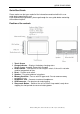
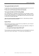
QUICK START GUIDE Quick Start Guide Please make sure that your read all of the information contained within this user guide before operating this unit. If you experience any problems, please go through the user guide before contacting the customer helpline. Position of the controls 1. Touch Screen 2. Charge Indicator – Displays the battery charging status. Red or Orange; charging, Green; fully charged. 3.
QUICK START GUIDE Charging the Battery Before using your GPS device for the first time, we recommend that you charge the unit for 5 hours via the mains/car charger, or until the charge light turns green. Plug the mains/car charger into the USB socket. NOTE: Charging via USB cable. It is possible to charge the unit via the USB cable but the charge time will be significantly increased. Also if the battery is very low the unit will not fully charge. The charging indicator on the unit will light up red.
QUICK START GUIDE Turning the Sat Nav Unit On/Off To switch the unit On slide the power switch located on the side of the unit to the On position, the unit will power up and display the warning screen. To switch the unit Off slide the power switch to the Off position. Turning the Sat Nav Unit Off Via Sleep Mode Press and hold down the sleep button on the top of the unit, after about 3 seconds the unit will enter sleep mode. Press and hold the button again, to bring the unit out of sleep mode.
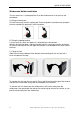
QUICK START GUIDE Windscreen Holder Installation The car mount has a suction pad that fits to the windscreen or a flat area on the dashboard. A. Fitting to windscreen Pull the lever away from the suction pad. Place the pad on the widescreen and push the lever towards the pad until it clicks into place. B. Fitting the holding bracket It is best to fit this to the unit before it is attached to the windscreen.
GETTING STARTED Starting Up Turn the ON/OFF button on the back of the unit to ON. The following screens will be displayed: When you press MENU, the following screens will be displayed: 10 Binatone Help Line: 0845 345 9677 (for UK only.
GETTING STARTED Settings NOTE: You do not need to enter the SETTINGS menu before you start to navigate. If you press on the SETTINGS icon the following screen is displayed. To exit this page or exit any subsequent page, press the cross at the top of the screen. Volume Press ’volume’ you can modify the volume level of the voice prompts. You can increase or decrease the level by clicking “ ” or “ ”. This can also be done via the navigation software later.
GETTING STARTED Default Reset to factory default settings. Calibrate This function calibrates the unit to respond to your screen taps. You will need to use this function only if the unit begins to respond inconsistently to your screen taps, then follow the on screen dissections. Once the calibration has been completed, press anywhere on the screen to return to the previous menu. Multi Media NOTE: if you press on the MULTI MEDIA icon the following screen is displayed.
GETTING STARTED Document Viewer This device supports, txt file format viewing only. Press the “Doc Viewer” to show the list of files available for viewing. The procedure for viewing documents is the same for viewing pictures. But once loaded the following screen will be shown. GPS Receiver NOTE: This page is for information only. You can view the number of satellite signals the unit is receiving also the strength of these signals.
GETTING STARTED NOTE: At least four GPS signals are required for the PND to function . There may be occasions within your home or surrounding area when the signal strength is limited and GPS navigation Mode may not be possible. This is quite normal of products of this type. Additional maps and upgrades: Please visit www.binatonegps.com or contact the helpline on 08452 459677 for more information. 14 Binatone Help Line: 0845 345 9677 (for UK only.
INTRODUCTION Introduction You have chosen a cutting-edge navigation system. Congratulations! Please enjoy using it. This navigation system leads you straight to your destination, whether you are travelling by car or on foot. You can navigate and plan your route with an easyto-use and intuitive interface, just by using your finger. You can also use this application to plan your trip to suit your personal preferences and interests and to save interesting destinations before your set off on your journey.
NAVIGATION MENU 2 Getting Started Please make sure that the battery in your device is charged (see page 7). Switch on the unit and from the menu select Navigation. The navigational software will start to load. First you will see the warning statement screen. Tap on “Accept” to confirm that you have read the statement and to continue. If you do not wish to be shown this screen in the future check the box next to “Don’t show this statement again”.
NAVIGATION MENU 3.1 Free Navigation 1 Compass – Shows your current heading by means of a letter, while the red part of the compass needle always points North. 2 Zoom out – Tap to zoom out on the map. 3 Speed – Shows your current speed. 4 Menu button – Tap to access the Free Navi Menu screen. (Only when in Free Navigation) 5 Time – Shows the current time (Note; this is set when you have a valid GPS lock). 6 Map scale – Show a scale bar which changes as the map zoom level is altered.
NAVIGATION MENU 3.2 Route Navigation 11 Speed limit– Shown when you exceed the speed limit of the current road, if switched on via the settings (see page 29). 12 Turn indicator – Shows a graphical representation of the next manoeuvre and the distance to the manoeuvre. Tap to replay the voice instruction. 13 Current road – Shows the name of the road you are currently on. 14 Menu button - Tap to access the navigation options.
NAVIGATION MENU 4 Browsing the Map When in Free Navigation or Route Navigation it is possible to browse the map so that you can look at parts of the map which are currently not shown. To move the map around use the stylus (if provided) or your finger to press and hold on a point on the map, then drag the map in the opposite direction you want to look at. E.g.
NAVIGATION MENU 6.1 Entering an Address/Postcode One of the most commonly used methods for inputting a destination into the unit, tap Address the screen will change to show the following. This screen shows a list of any previously used cities/towns. You will also be able to enter a new city name as well as changing the country you wish to search within. Every time you enter a new city it will be added to the list of recent cities so that it can be quickly used in the future.
NAVIGATION MENU to confirm or double tap the list item. The screen will change to the Address Search window with the selected city now shown on the city field. Note: That there is no need to enter any special characters in the city name as the unit will search for and match whether these are entered or not. E.g. for CÁDIZ simply enter CADIZ. Tap or (number keyboard) to enter a space. Tap to delete an incorrect letter. Tap or to change between numbers and letters (number keyboard only).
NAVIGATION MENU you see the correct road. Select the desired road and tap or double tap to confirm. You can also enter the name of the road by tapping on the white box at the top. When entering an address you have the following options; Tap . Once you have fully entered the destination you want to navigate to and are happy, you will now be taken to the Route Plan screen (see page 34).
NAVIGATION MENU which allows you to search for the name of a particular POI. After entering the whole name or part name tap . The screen will change to show a list of all possible matching POI, scroll through the list of POI until you find the one you are looking for and then tap taken to the Route Plan screen (see page 34). or double tap to confirm. You will be At any point tap to return to the POI Category screen, if you are on the POI Category screen tapping will return you to the POI menu etc.
NAVIGATION MENU 6.3 Selecting an Entry from the Address Book This option allows you to quickly select one of your address book entries to use as your destination. Tap Address Book the screen will change to show the address book screen and a list of any stored entries. Scroll through the list of entries using the or keys until you find the entry you require. Select it so that it is highlighted orange and tap or double tap to confirm. The screen will then change to show the Route Plan screen (see page XX).
NAVIGATION MENU current/last known GPS position or the last position you viewed on the map. You can then browse the map (see page 24) and select a point you want to navigate to by placing the cursor. After placing the cursor at a point on the map, it may contain further information, i.e. if there is more than one POI at that point. In this case you can use the between the multiple points. Tap arrows to scroll to go back to the Search Menu screen. Tap to confirm the point.
NAVIGATION MENU navigated to the most. The screen will change to show the Route Plan screen (see page 34). In order to use this option you will need to set your home address first. If you select this option without setting your home address first, the unit will ask you if you wish to set it now. Alternatively this can be done using the Set Home Address found in the Settings menu (see page 28).
NAVIGATION MENU 7.3 Motorway Sign Post When switched on this option does two things. Firstly when driving down major roads and motorways, it will show information about the approaching junctions. Secondly when you approach your junction the screen will change to clearly show that this is your junction. Approaching junctions – While you are currently navigating a planned route and are on a major road or motorway, the unit will show you information about the approaching junctions along the planned route.
NAVIGATION MENU 7.5 Auto Zoom Allows you to activate or deactivate the auto zoom feature. When auto zoom is activated the unit will automatically zoom the map during navigation according to your speed, the faster you are travelling the more the map will zoom out to give you a better view of the road ahead. When activated the box will be shown with a tick. 7.6 Simulation Speed This option allows you to change the speed at which a simulation of a route is carried out.
NAVIGATION MENU 8.2 Safety Alert Tap to open the safety alert options screen. From this screen you can set two separate safety alerts. Speed camera on – This lets you activate or deactivate the speed camera warning, when activated the unit will warn you of an approaching speed camera visually and shows you the distance to the camera. When the option is shown with an orange indicator it is activated.
NAVIGATION MENU Each recording will be logged with the following information. Viewing a trace record: Select the trace record you want to view. The currently selected trace record will be highlighted orange. Then use the button to view the trace record on the map. . The trace record will be shown as a When active the button will then change to show slightly opaque orange line with green arrows indicating the direction of travel. Note: it is only possible to show one trace at a time.
NAVIGATION MENU Name –You can then enter a name for your address book entry; which will be shown in the address book list. If no name is entered then the address will be automatically entered in this field and shown as the name. Address –You can then change the way the address is shown or add further information. Note: Changing the address does not change the location of the address book entry, just the way the name is shown. Tel –You can then enter a telephone number for your address book entry.
NAVIGATION MENU 8.5 Day/Night Mode Allows you to change the map so that the colour and brightness are optimal for driving in either day time or night time conditions. There are two options to choose from; manually and automatic. Manually – when selected allows you to either simply select day or night mode, by tapping either or to make your selection. Automatic – When selected allows you to set a start and end time, when the time is between these two times the unit will be set to Day mode.
NAVIGATION MENU 8.8 Miles/Kilometre Tapping this option will change the units of distance; this change will be reflected both on the map and in the voice directions. Tap this option to change between Miles and Kilometres. The currently selected option will be shown on the screen. 8.9 About Tapping this option will show you information relating to the version of navigation software you are running. 8.
NAVIGATION MENU 8.12 Calibration This option allows you to calibrate the screen so that it responds accurately to your screen taps. You will need this function only if the unit begins to respond inconsistently to your screen taps. When tapped your will be shown a warning screen, tap to confirm you would like to calibrate the screen. The screen will change to the calibration screen; follow the onscreen instructions in order to complete the calibration process.
NAVIGATION MENU To add waypoints tap , you will be taken to the Search Menu screen. You can then enter your waypoint in the same way that you did for your destination (see page 34). To remove a waypoint/destination, select the desired location so that it is highlighted orange and then tap . The waypoint/destination will be removed from the list.
NAVIGATION MENU 10 Route Navigation Menu While navigating or simulating a route tapping the button will take you to the Route Navigation Menu. From here you can obtain detailed information about the route you have calculated or make changes to the settings without having to exit navigation. 10.1 Route Plan This takes you back to the Route Plan Menu (see page 34). From here you can will add/remove waypoints, change the Route Options or even simulate the route.
NAVIGATION MENU 10.4 Go To Tapping this option will automatically cancel the route and take you to the Search menu (see page 19). Were you will be able to enter a new destination to navigate too. 10.5 Route Information Tapping this option will detail the route in text format and contains useful information about the route you have planned on a new screen.
FREQUENTLY ASKED QUESTIONS Frequently asked questions I can’t find an address. Please make sure you have correctly spelt your entry. If you do not know how an address is spelt correctly, simply enter the parts of the address, you know of sure (e.g., “ond”, “Leic” for Leicester Square in London). Then browse the results list and look for the address. Also make sure the the city in which you are looking for an address is correct.
TECHNICAL SPECIFICATIONS Technical Specifications CPU Atlas IV 500 MHz or above Operating System Microsoft WinCE.NET 6.0 Core Version Antenna I/O Memory 64MB DDR1 Built-in Display 4.3″colour TFT touch screen Weight 0.168 kg Input Method Software keyboard Expansion Slot SD card Speaker Built-in 1.0 W loud speaker USB USB Client for Active Sync Battery Re-chargeable Lithium Polymer battery Dimension 39 Built-in GPS high sensitivity receiver (64 channels) 119mmx74.
TECHNICAL SPECIFICATIONS BINATONE TELECOM PLC 1 Apsley Way London NW2 7HF,United Kingdom. Tel: +44(0) 20 8955 2700 Fax: +44(0) 20 8344 8877 e-mail: binatoneuk@binatonetelecom.co.uk ________________________________________ . EC Declaration of Conformity We the manufacturer / Importer : Binatone Telecom Plc 1 Apsley Way London NW2 7HF, United Kingdom.