
Operating instructions

Map Page with Datalink Weather
600-00108-000 Rev 07 -88- Entegra EX5000
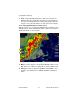
11.2 Map Page with Datalink Weather
The Map Page is the primary display for the Datalink weather
information. Displayed on the Map Page are NEXRAD radar images,
lightning strike information, AIRMETs/SIGMETs, graphical METAR
symbols, and TFRs.
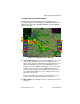
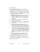
Figure 11.1 Datalink Weather—Map Page
1) Sensor Status Block—The Sensor Status Block gives the status
of the weather information presented. The Lightning sensor
status reflects whether the lightning information displayed on the
Map is from Datalink or from an on-board lightning sensor, if
installed. If space is available, the Datalink sensor status, which
includes the age of the most recent NEXRAD radar image, is
shown on the bottom line of the upper block. If optional sensors
are installed, the Datalink sensor icon is displayed in the lower
left portion of the screen.
For more information about the Sensor Status Block icons, see
Table 13.1 Sensor Status Block Symbols on page 112.
2) Map Symbols—Described in Section 2.1, "Map Page—Controls"
on page 7.
3
1
4
2 2