
Operating instructions


Map Page—Controls
600-00108-000 Rev 07 -8- Entegra EX5000
Datalink, Display Off. When only one source of lightning data
is installed, only the appropriate modes are available. See
your lightning sensor User’s Manual for further details.
■ Clear Strikes—Removes current lightning symbols to allow
for the refresh of lightning data when using a onboard
lightning sensor. Does not remove Datalink lightning.
■ WX Rprts—Controls the type of Datalink weather information
displayed on the map, as follows:
◆ All—Displays graphical METARs, AIRMETs, and
SIGMETs.
◆ METARS—Displays graphical METARs only.
◆ AIRMET—Displays graphical AIRMETs only.
◆ SIGMET—Displays graphical SIGMETs only.
◆ DSPLY OFF—Turns off display of all weather
information.
For more information about Datalink functions, see Section
11.2, "Map Page with Datalink Weather" on page 88.
■ Emerg. Checklist—Opens the Emergency Checklist Page.
For more information, see Section 7.4, "Emergency
Checklists" on page 44.
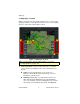
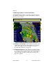
2) Map Functions—Controls basic look of the map in terms of
orientation, number of elements, and base map.
■ View—Orients the map for either Track/Heading Up or North
Up. FORWARD and CENTER views are oriented with Track/
Heading Up. North Up orients the map to true North, with the
ownship symbol rotated to show track/heading.
■ Declutter—Controls the four levels of navigation database
detail on the Map from most to least:
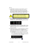
Note: (For WX-500 only.) The lightning sensor maps thunderstorm activity
by monitoring electrical discharge activity within a 200-mile radius of the
aircraft. If the display range is set to less than 25NM, only lightning strikes
within 25NM are shown. If the display range is set to greater than 25NM, all
lightning strikes are shown.
➡➡➡