
Operating instructions
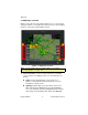

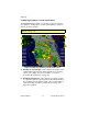


Map Page Symbols—Terrain and Position
600-00108-000 Rev 07 -12- Entegra EX5000
3) Sensor Status Box—Displays the status of the available
sensors including radar, traffic, lightning and both 2-Way Datalink
and Broadcast Datalink. The NEXRAD (NXR) display includes
the NEXRAD data age, which is the elapsed time since the
product was created by the weather provider.
See Table
13.1 Sensor Status Block Symbols on page 112 for more
information on status box symbols. (Optional Engine Instrument
Sensor Status information is described in Table 13.10 Engine
Instrument Data Block Information on page 118).
4) Compass Rose/Range Ring—Displays a 360-degree or 120-
degree compass circle or arc and indicates current range setting.
The range number is the distance from the airplane symbol to the
compass arc.
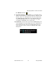
Table 2.1 Track Indicator Graphics
Heading Track Map Orientation
Heading Desired
Track
North Up
Track Heading Heading Up
Actual
Track
Track Up
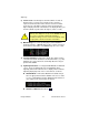
!
When using Datalink weather, monitor the data age so
you are aware of the time elapsed since the last
weather update.
Note: NEXRAD is the only Broadcast Datalink product on the EX5000 that
displays the time since the product was created by the weather provider.
Refer to the Trip page for information on all other weather products.